")
Panasonic LX100 at an effective 24mm — 1/125 sec, f/5.6, ISO 200 — map & image data — nearby photos
Off The Northern Coast
Sea of Japan from Fukui Prefecture
日本海、福井県の若狭三方から
先週なんとなく国道367号線と国道162号線のゼンセンを乗るのは面白いかもと思いました。 普通はサイクリングすろと国道を抜きたいですが、今回ワザトこの国道の全線を乗る。京都市内の五条烏丸で始まる国道367号線を乗って北へ。 そして、日本海の近くの福井県三方で始まる国道162号線で南へ。 結局225キロをゆったり走りました。京都市周辺以外には道は良かった。車は少なかった。
Last week I got it into my head to do a “theme” bicycle ride: ride the length of National Routes 367 and 162. The total of both is about 183km (114mi), but with the transition between and bits before and after, the ride (see at Strava) ended up being 225km (140mi).
Both routes have endpoints in Kyoto, and many fun rides include parts of them, but in most cases the national routes are used begrudgingly as a quick way to get to the fun part of the ride. The ride is fun despite the parts on the national route, which with traffic and tunnels, generally fall into the “less fun” category.
So, I thought it'd be something (what I'm not exactly sure) to face this head on and make them the point of the ride.
For reference, here they are on the map:
 long. National Route 162 is in green; it's 127km (78mi) long (I live at the yellow star)")
image data
National Route 367 is in purple; it's about 57km (35mi) long.
National Route 162 is in green; it's 127km (78mi) long
(I live at the yellow star)
I went to the base of the purple route and took it north, then continued to the top of the green route, by which I then returned to Kyoto.
Here's the view on Strava:
")
Panasonic LX100 at an effective 32mm — 1/320 sec, f/5.6, ISO 200 — map & image data — nearby photos
Start of National Route 167
Corner of Gojo and Karasuma Streets, downtown Kyoto Japan
7:36am
 -- Kyoto, Japan -- Copyright 2016 Jeffrey Friedl, https://regex.info/blog/ -- This photo is licensed to the public under the Creative Commons Attribution-NonCommercial 4.0 International License http://creativecommons.org/licenses/by-nc/4.0/ (non-commercial use is freely allowed if proper attribution is given, including a link back to this page on http://regex.info/ when used online)")
Panasonic LX100 at an effective 24mm — 1/125 sec, f/5, ISO 200 — map & image data — nearby photos
First Turn Coming Up
7:53am - taken while cycling at 25 kph (15 mph)
Within the city the idea of a “National Route” is merely notational, and it shifts streets a few times before it settles on the actual stretch of blacktop that heads north into the mountains. There are only three such turns on the entire length of road, and all are within the first little bit, but I managed to screw even that up and managed to get off course in the first 10 minutes. Sigh.
But, I quickly recovered and that was the last navigational mistake of the day, thank goodness.
Soon I was out of the city...
")
Panasonic LX100 at an effective 24mm — 1/320 sec, f/4.5, ISO 200 — map & image data — nearby photos
An Hour In
8:45am — typical scene
 -- Otsu, Shiga, Japan -- Copyright 2016 Jeffrey Friedl, https://regex.info/blog/ -- This photo is licensed to the public under the Creative Commons Attribution-NonCommercial 4.0 International License http://creativecommons.org/licenses/by-nc/4.0/ (non-commercial use is freely allowed if proper attribution is given, including a link back to this page on http://regex.info/ when used online)")
Panasonic LX100 at an effective 24mm — 1/125 sec, f/4.5, ISO 1250 — map & image data — nearby photos
Monkeys!
crop from a larger photo; taken while climbing a steep rise at 12 kph (8 mph)
 than to climb up -- Otsu, Shiga, Japan -- Copyright 2016 Jeffrey Friedl, https://regex.info/blog/ -- This photo is licensed to the public under the Creative Commons Attribution-NonCommercial 4.0 International License http://creativecommons.org/licenses/by-nc/4.0/ (non-commercial use is freely allowed if proper attribution is given, including a link back to this page on http://regex.info/ when used online)")
Panasonic LX100 at an effective 24mm — 1/125 sec, f/4.5, ISO 250 — map & image data — nearby photos
Steep Climb!
this is much more fun to go down (like this and this) than to climb up
The weather forecast for Kyoto had a 0% chance of rain, but upon exiting a long tunnel an hour and a half in, at the highest elevation I'd reach all day, I was reminded that I was no longer in Kyoto... it was cold, windy, and rainy.
It rained on and off for much of the day until I got back to Kyoto.
 -- Otsu, Shiga, Japan -- Copyright 2016 Jeffrey Friedl, https://regex.info/blog/ -- This photo is licensed to the public under the Creative Commons Attribution-NonCommercial 4.0 International License http://creativecommons.org/licenses/by-nc/4.0/ (non-commercial use is freely allowed if proper attribution is given, including a link back to this page on http://regex.info/ when used online)")
Panasonic LX100 at an effective 24mm — 1/125 sec, f/4.5, ISO 500 — map & image data — nearby photos
Passing The Turnoff To Kuta
9:12am - taken while cycling at 41 kph (26 mph)
An hour and a half into Route 367 I came to the turnoff to the Kuta region. I'd just been here on the ride mentioned in the previous point, as the fork between fast and safe, where I'd opted away from the national route in the increasing darkness. No worries about that today.
Rough calculations told me that I'd make it home by daylight if I could maintain a 20kph pace (12½mph), including all stops. (I left at about 7:30am; sunset was about 5:30pm).
That's an easy pace to maintain on all but the few steepest sections of these big modern roads, but the devil is in the “including all stops” detail. It's amazing how much time you can lose pausing for traffic lights, traffic, taking photos, buying a drink, eating, or just to catch your breath, much less to mechanical issues like flat tires. So it was comforting to compare the hours ticking off the clock, to the kilometers ticking up on the readout, and realize that I was keeping comfortably within range.
(My cycling computer, a Garmin 820, has a “virtual partner” feature where it can ostensibly tell you how far ahead or behind a certain pace you are, but it was ridiculously incorrect — “2 minutes behind” instead of “35 minutes ahead”, for example. Perhaps somehow its functionality changes if you're navigating a route? Sigh, I may have to actually hunt down the manual.)
 into Route 367 9:23am - taken while cycling at 18 kph (11 mph) -- Takashima, Shiga, Japan -- Copyright 2016 Jeffrey Friedl, https://regex.info/blog/ -- This photo is licensed to the public under the Creative Commons Attribution-NonCommercial 4.0 International License http://creativecommons.org/licenses/by-nc/4.0/ (non-commercial use is freely allowed if proper attribution is given, including a link back to this page on http://regex.info/ when used online)")
Panasonic LX100 at an effective 24mm — 1/125 sec, f/4.5, ISO 1000 — map & image data — nearby photos
Wet and Rainy
but little traffic this far north, 44km (28mi) into Route 367
9:23am - taken while cycling at 18 kph (11 mph)
")
Panasonic LX100 at an effective 24mm — 1/320 sec, f/5.6, ISO 200 — map & image data — nearby photos
Crossing a River
over a riverside campground
 -- おみやげのカネハチ -- Takashima, Shiga, Japan -- Copyright 2016 Jeffrey Friedl, https://regex.info/blog/ -- This photo is licensed to the public under the Creative Commons Attribution-NonCommercial 4.0 International License http://creativecommons.org/licenses/by-nc/4.0/ (non-commercial use is freely allowed if proper attribution is given, including a link back to this page on http://regex.info/ when used online)")
Panasonic LX100 at an effective 24mm — 1/640 sec, f/4.5, ISO 200 — map & image data — nearby photos
Kutsuki Village
near the turnoff to the ski grounds mentioned in the previous post
9:37am - taken while cycling at 13 kph (8 mph)
I'd never been farther north than this village, so I was happy to see new road. I was greeted with a 130m (430') climb, then a descent toward the end of the road...
 from the start -- Takashima, Shiga, Japan -- Copyright 2016 Jeffrey Friedl, https://regex.info/blog/ -- This photo is licensed to the public under the Creative Commons Attribution-NonCommercial 4.0 International License http://creativecommons.org/licenses/by-nc/4.0/ (non-commercial use is freely allowed if proper attribution is given, including a link back to this page on http://regex.info/ when used online)")
Panasonic LX100 at an effective 44mm — 1/125 sec, f/2.6, ISO 200 — map & image data — nearby photos
The End of National Route 367
9:57am — 2:20 and 57km (35mi) from the start
After finishing National Route 367, I had to continue away from Kyoto another hour's ride farther north toward the start of National Route 162, and as I started that leg, I made a shocking discovery: the gear shifters on my bike was almost out of battery!
My bike has Shimano Di2 electric derailleurs, powered by a battery that I have to charge a few times a year. The previous night I'd checked and found it had 29% battery left, enough to last a month. At the start this morning, though, the readout said 20%, so I started to worry that the readout wasn't trustworthy, but it remained at 20% halfway up Route 367, so my mind was put at ease. But now, at the end of Route 367, I was shocked to see it at 10%! If I were to run out of battery, I'd be stuck in whatever gear the bike was in for the rest of the ride.
To save on battery I removed the wireless-communication module (which communicated the untrustworthy battery level to my cycling computer), and tried to avoid shifting as much as possible. In one sense it created a perhaps useful kind of training as I stuck with a single gear through a much wider range of cadence/power than I would naturally do.
With some trepidation I made my way north on Route 303, filled with trucks and blistering cross winds. I'd ridden in strong winds before (e.g. this ride to Osaka), but never at high speed. I guess in this case I was lucky for the trucks, because traffic was moving at the posted 50kph speed limit, so I found some shelter in the lee behind a truck and could avoid some of the stronger gusts.
 -- Mikatakaminaka-gun -- Mikatakaminaka-gun, Fukui, Japan -- Copyright 2016 Jeffrey Friedl, https://regex.info/blog/ -- This photo is licensed to the public under the Creative Commons Attribution-NonCommercial 4.0 International License http://creativecommons.org/licenses/by-nc/4.0/ (non-commercial use is freely allowed if proper attribution is given, including a link back to this page on http://regex.info/ when used online)")
Panasonic LX100 at an effective 24mm — 1/500 sec, f/5.6, ISO 200 — map & image data — nearby photos
Typical Scene
10:24am - taken while cycling at 17 kph (11 mph)
, and a doughnut -- Mikatakaminaka-gun -- Mikatakaminaka-gun, Fukui, Japan -- Copyright 2016 Jeffrey Friedl, https://regex.info/blog/ -- This photo is licensed to the public under the Creative Commons Attribution-NonCommercial 4.0 International License http://creativecommons.org/licenses/by-nc/4.0/ (non-commercial use is freely allowed if proper attribution is given, including a link back to this page on http://regex.info/ when used online)")
Panasonic LX100 at an effective 32mm — 1/125 sec, f/2.2, ISO 250 — map & image data — nearby photos
Lunch
at a convenience store, 3½ hours in
chicken breast, rice ball (already eaten), and a doughnut
")
Panasonic LX100 at an effective 24mm — 1/320 sec, f/5.6, ISO 200 — map & image data — nearby photos
Approaching National Route 162
11:13am - it begins at the next left
 miles away -- Mikatakaminaka-gun -- Mikatakaminaka-gun, Fukui, Japan -- Copyright 2016 Jeffrey Friedl, https://regex.info/blog/ -- This photo is licensed to the public under the Creative Commons Attribution-NonCommercial 4.0 International License http://creativecommons.org/licenses/by-nc/4.0/ (non-commercial use is freely allowed if proper attribution is given, including a link back to this page on http://regex.info/ when used online)")
Panasonic LX100 at an effective 24mm — 1/320 sec, f/5.6, ISO 200 — map & image data — nearby photos
Anonymous-Looking Intersection
Kyoto is to the left, 125km (78) miles away
The first few hundred meters of National Route 162 is a flyover bridge above some railroad tracks, and “officially” bicycles are not allowed on that short stretch. No one was around so I took it, and can't understand why bicycles would be prohibited... it would have been perfectly safe even in heavy traffic. It took 30 seconds to transverse.
15 minutes of pleasant cycling later, I arrived at the first tunnel of National Route 162:
")
Panasonic LX100 at an effective 24mm — 1/125 sec, f/2.2, ISO 200 — map & image data — nearby photos
National Route 162 Tunnel #1
Tunnels with traffic can be particularly dangerous for bicycles, so we're generally aware of them and their condition when planning a route, and try to avoid them when conditions warrant. But with today's theme ride, I'd take all tunnels however they came.
And they came. National Route 367 has six tunnels over its length. They tend to be safer when riding south-to-north because the slope lets you ride with traffic, which is why I did today's loop in this counter-clockwise direction.
The roads I took to move to the start of National Route 162 included two tunnels.
National Route 162, though, has 18(!) tunnels over its length.
Passing through this first tunnel, I emerged to find the Sea of Japan:
")
Panasonic LX100 at an effective 43mm — 1/160 sec, f/5.6, ISO 200 — map & image data — nearby photos
First View of the Ocean
11:33am - four hours in
")
Panasonic LX100 at an effective 24mm — 1/160 sec, f/5.6, ISO 200 — map & image data — nearby photos
A Minute Later
from sea level
The road hugs the coast for a while, but rises and falls sharply. During one of the rises, I took the photo that leads this post.
 -- Obama, Fukui, Japan -- Copyright 2016 Jeffrey Friedl, https://regex.info/blog/ -- This photo is licensed to the public under the Creative Commons Attribution-NonCommercial 4.0 International License http://creativecommons.org/licenses/by-nc/4.0/ (non-commercial use is freely allowed if proper attribution is given, including a link back to this page on http://regex.info/ when used online)")
Panasonic LX100 at an effective 24mm — 1/125 sec, f/5.6, ISO 640 — map & image data — nearby photos
Typical Scene
11:47am - taken while cycling at 40 kph (25 mph)
")
Panasonic LX100 at an effective 24mm — 1/160 sec, f/5.6, ISO 200 — map & image data — nearby photos
Typical Village
nestled in a cove
")
Panasonic LX100 at an effective 24mm — 1/125 sec, f/4.5, ISO 200 — map & image data — nearby photos
Valley View from a Bridge
of rice fields both abandoned and in use
 -- Obama, Fukui, Japan -- Copyright 2016 Jeffrey Friedl, https://regex.info/blog/ -- This photo is licensed to the public under the Creative Commons Attribution-NonCommercial 4.0 International License http://creativecommons.org/licenses/by-nc/4.0/ (non-commercial use is freely allowed if proper attribution is given, including a link back to this page on http://regex.info/ when used online)")
Panasonic LX100 at an effective 24mm — 1/200 sec, f/5, ISO 200 — map & image data — nearby photos
Hugging the Coast
12:03pm - taken while cycling at 40 kph (25 mph)
 -- Obama, Fukui, Japan -- Copyright 2016 Jeffrey Friedl, https://regex.info/blog/ -- This photo is licensed to the public under the Creative Commons Attribution-NonCommercial 4.0 International License http://creativecommons.org/licenses/by-nc/4.0/ (non-commercial use is freely allowed if proper attribution is given, including a link back to this page on http://regex.info/ when used online)")
Panasonic LX100 at an effective 24mm — 1/320 sec, f/5.6, ISO 200 — map & image data — nearby photos
Descending into Obama City
12:28pm - taken while cycling at 28 kph (17 mph)
I wanted to stop by The Mermaid to replicate this photo, but National Route 162 doesn't pass by (it's a block or two over), so I'd have to leave it for another day.
 -- Obama, Fukui, Japan -- Copyright 2016 Jeffrey Friedl, https://regex.info/blog/ -- This photo is licensed to the public under the Creative Commons Attribution-NonCommercial 4.0 International License http://creativecommons.org/licenses/by-nc/4.0/ (non-commercial use is freely allowed if proper attribution is given, including a link back to this page on http://regex.info/ when used online)")
Panasonic LX100 at an effective 24mm — 1/160 sec, f/5.6, ISO 200 — map & image data — nearby photos
Right Turn South, Toward Kyoto
12:33pm - taken while cycling at 23 kph (14 mph)
The sign in the photo above had the first mention of Kyoto I'd noticed.
In the photo above, on the left side of the road, there's a temperature readout (23℃, about 74℉). Just behind it, a man dressed in blue is standing... sort of hiding.
 -- Obama, Fukui, Japan -- Copyright 2016 Jeffrey Friedl, https://regex.info/blog/ -- This photo is licensed to the public under the Creative Commons Attribution-NonCommercial 4.0 International License http://creativecommons.org/licenses/by-nc/4.0/ (non-commercial use is freely allowed if proper attribution is given, including a link back to this page on http://regex.info/ when used online)")
Panasonic LX100 at an effective 24mm — 1/125 sec, f/5.6, ISO 200 — map & image data — nearby photos
Hello
12:33pm - taken while cycling at 23 kph (14 mph)
In the far background is another policeman with a red “STOP!” flag, who will run out into traffic to stop someone the first policeman identifies as breaking some law. I most commonly see them standing like this near intersections looking for folks who make illegal turns (seemingly ignoring the plethora of folks who brazenly run red lights in the most staggeringly-obvious way), but in this case the first policeman was standing without a good view of an intersection, so I'm guessing he's on the watch for those not wearing seat belts.
I wasn't wearing a seat belt, but somehow skated by safely. 🙂
 in -- Obama, Fukui, Japan -- Copyright 2016 Jeffrey Friedl, https://regex.info/blog/ -- This photo is licensed to the public under the Creative Commons Attribution-NonCommercial 4.0 International License http://creativecommons.org/licenses/by-nc/4.0/ (non-commercial use is freely allowed if proper attribution is given, including a link back to this page on http://regex.info/ when used online)")
Panasonic LX100 at an effective 44mm — 1/125 sec, f/4, ISO 200 — map & image data — nearby photos
First Distance-to-Kyoto Sign
12:34pm - about five hours and 113km (70mi) in
Not long after this, my front derailleur stopped working, an indication that the battery had reached a critically-low level. By design, the front derailleur stops working first. Eventually, the rear derailleur will stop as well. I still had 80 or 90 kilometers left to get home, and I wasn't in the mood to ride it on a fixie (a bicycle without the ability to change gears), so I went into ultra-conservative mode, changing gears only at the top or bottom of big climbs.... maybe once every 10 or 20 kilometers.
")
Panasonic LX100 at an effective 38mm — 1/125 sec, f/4.5, ISO 200 — map & image data — nearby photos
Rest Break
1:47pm - as an imminent rain starts to gather
")
Panasonic LX100 at an effective 24mm — 1/60 sec, f/1.7, ISO 320 — map & image data — nearby photos
Respite from the Rain
2:05pm - about half way into the tunnel count for National Route 162
Not long after this came the most-wonderful Miyama Morisato Descent, a lovely descent on gently curving very-well-paved no-traffic road, so it was painful to be stuck in the small chainring... I'd spin out at about 45kph. I still managed a PR (personal record) on it because the one other time I'd done it was with Gorm, where descents are social.
Next time.
")
Panasonic LX100 at an effective 60mm — 1/125 sec, f/3.5, ISO 200 — map & image data — nearby photos
House
 -- Nantan, Kyoto, Japan -- Copyright 2016 Jeffrey Friedl, https://regex.info/blog/ -- This photo is licensed to the public under the Creative Commons Attribution-NonCommercial 4.0 International License http://creativecommons.org/licenses/by-nc/4.0/ (non-commercial use is freely allowed if proper attribution is given, including a link back to this page on http://regex.info/ when used online)")
Panasonic LX100 at an effective 24mm — 1/125 sec, f/5, ISO 200 — map & image data — nearby photos
Looking Back
on a steep climb made without shifting... I don't know how fixie folks do it
( despite stopping for photos, I still made a PR (new personal record), which surprised me )
")
Panasonic LX100 at an effective 26mm — 1/125 sec, f/4.5, ISO 200 — map & image data — nearby photos
About the Century Mark
in Miyama where I'd passed on a ride last week
(a “century” in cycling is a 100-mile (160.9km) ride)
")
Panasonic LX100 at an effective 34mm — 1/125 sec, f/5, ISO 200 — map & image data — nearby photos
Farmland
 to go 2:59pm - taken while cycling at 22 kph (14 mph) -- Nantan, Kyoto, Japan -- Copyright 2016 Jeffrey Friedl, https://regex.info/blog/ -- This photo is licensed to the public under the Creative Commons Attribution-NonCommercial 4.0 International License http://creativecommons.org/licenses/by-nc/4.0/ (non-commercial use is freely allowed if proper attribution is given, including a link back to this page on http://regex.info/ when used online)")
Panasonic LX100 at an effective 24mm — 1/125 sec, f/3.5, ISO 200 — map & image data — nearby photos
Long Climb
only 52km (32mi) to go
2:59pm - taken while cycling at 22 kph (14 mph)
")
Panasonic LX100 at an effective 24mm — 1/125 sec, f/4.5, ISO 200 — map & image data — nearby photos
Bigger Village
3:33pm
By now I was far enough south to be out of the rain for the rest of the trip.
")
Panasonic LX100 at an effective 24mm — 1/125 sec, f/1.7, ISO 200 — map & image data — nearby photos
Ramen Shop
ラーメン専門店キャプテン
My derailleur aside, things were going great, so I stopped into a ramen place near the Kasa Tunnel, for wild-boar raman...
")
Panasonic LX100 at an effective 24mm — 1/60 sec, f/1.7, ISO 500 — map & image data — nearby photos
Yum
After eating, I had just 20km (12½mi) to go on National Route 162, mostly downhill, with three final tunnels. There was one short climb that had me worried from a derailleur point of view... I wanted the hardest gear for all the downhill, but worried that I might be stuck in it for the climb.
I was aided in my lack of fast downhill gears by slow traffic, so I could just hum along smoothly until a short traffic stop for road construction at which I could get in front of a big truck. Once construction allowed us to move again, I guess everyone was stuck behind the truck because I had the road to myself for the rest of the way into Kyoto. It was a bit eerie. Despite being stuck in a small front chainring, I made a PR on the descent into Takao.
That short climb turned out not to be a problem, and I soon found myself in the city.
 -- Kyoto, Japan -- Copyright 2016 Jeffrey Friedl, https://regex.info/blog/ -- This photo is licensed to the public under the Creative Commons Attribution-NonCommercial 4.0 International License http://creativecommons.org/licenses/by-nc/4.0/ (non-commercial use is freely allowed if proper attribution is given, including a link back to this page on http://regex.info/ when used online)")
Panasonic LX100 at an effective 24mm — 1/125 sec, f/8, ISO 640 — map & image data — nearby photos
Back in Kyoto City
4:51pm - taken while cycling at 17 kph (11 mph)
")
Panasonic LX100 at an effective 35mm — 1/125 sec, f/2.3, ISO 200 — map & image data — nearby photos
My First Google Car Sighting
unlikely, but maybe I'll show up here some day
 -- Kyoto, Japan -- Copyright 2016 Jeffrey Friedl, https://regex.info/blog/ -- This photo is licensed to the public under the Creative Commons Attribution-NonCommercial 4.0 International License http://creativecommons.org/licenses/by-nc/4.0/ (non-commercial use is freely allowed if proper attribution is given, including a link back to this page on http://regex.info/ when used online)")
Panasonic LX100 at an effective 35mm — 1/125 sec, f/2.5, ISO 200 — map & image data — nearby photos
The End is Near
National Route 162 dead-ends at the next intersection
5:02pm - taken while cycling at 32 kph (20 mph)
With all the stops, National Route 162 took about 5 hours 45 minutes, so with stops I averaged about 21 kph. (For reference, on this ride I averaged almost 32kph for 180km — 19.7mph for 112 mi — though that route was flatter.)
 -- Kyoto, Japan -- Copyright 2016 Jeffrey Friedl, https://regex.info/blog/ -- This photo is licensed to the public under the Creative Commons Attribution-NonCommercial 4.0 International License http://creativecommons.org/licenses/by-nc/4.0/ (non-commercial use is freely allowed if proper attribution is given, including a link back to this page on http://regex.info/ when used online)")
Panasonic LX100 at an effective 24mm — 1/125 sec, f/2.2, ISO 200 — map & image data — nearby photos
Heading Home
5:10pm - taken while cycling at 29 kph (18 mph)
I still felt great, so wanted to use the opportunity of having just ridden 200+km to pile on a few more miles, so I headed up to Shogunzuka, where I used to go up often for sunset photos...
 -- Shogunzuka Overlook (将軍塚) -- Kyoto, Japan -- Copyright 2016 Jeffrey Friedl, https://regex.info/blog/ -- This photo is licensed to the public under the Creative Commons Attribution-NonCommercial 4.0 International License http://creativecommons.org/licenses/by-nc/4.0/ (non-commercial use is freely allowed if proper attribution is given, including a link back to this page on http://regex.info/ when used online)")
Panasonic LX100 at an effective 46mm — 1/100 sec, f/2.6, ISO 200 — map & image data — nearby photos
Boring View Today
Shogunzuka Overlook (将軍塚)
Still wanting to add a few more miles, I headed to a sort-of-far Liquor Mountain store to fetch some treat-for-a-job-well-done Sangria Peñasol, which I discovered some years ago at a wine-tasting event.
")
Panasonic LX100 at an effective 24mm — 1/100 sec, f/1.7, ISO 200 — map & image data — nearby photos
Yum in a Carton
fits nicely in one of the jersey-back pockets
Here's the Relive.cc video....
The first thing I did when I got home was to charge the Di2 battery.

Panasonic LX100 at an effective 38mm — 1/125 sec, f/4.5, ISO 200 — map & image data — nearby photos
Ready to Start
Stephanie and Manseki
7:30am, Kyoto Japan
I had quite the bicycle ride last week; this blog post is mostly a diary for my own memory.
What started out as a pleasant ride with friends ended up 12 hours later being a test of nighttime eyesight and creative headlight battery management.
The Relive.cc video of the ride gives a sense of this never-ending ride.
I planned a longish ride to the north of Kyoto, but would be joined at the beginning by Stephanie and Manseki. We'd intended to head over the mountains via the Hiei climb, but rush-hour traffic on the narrow road made us turn around and head north via Ohara.

Panasonic LX100 at an effective 24mm — 1/320 sec, f/5.6, ISO 200 — map & image data — nearby photos
Among the Spider Lilies of Ohara
大原の彼岸花の中で
")

SC-02H at an effective 21mm — 1/700 sec, f/1.7, ISO 50 — map & image data — nearby photos
photo by Manseki Kanemitsu
From Ohara, Stephanie returned to Kyoto for an appointment, while Manseki and I continued north up the Tochu climb, then down toward Lake Biwa.
My main goal of the ride was to do a particular climb way up north, but also try a bunch of short-but-intense tangential climbs hanging off the route along the way. I'd found them by scouring satellite photos via Google Earth looking for what seemed to be paved roads up into the mountains; until I tried them, I didn't know whether access was even allowed, or whether they were paved, but this kind of exploration is all part of the fun.
I had done some of these climbs on “Disappointing and Truncated “Search for The Big Steep” Ride” earlier in the month, including the 1.4km @ 13% “Blueberry Fields” climb and the 1.6km @ 12% Kurihara climb.

Panasonic LX100 at an effective 75mm — 1/125 sec, f/5.6, ISO 200 — map & image data — nearby photos
Manseki Finishing
the Myodokai Climb
妙道会のHCの終点
1.7km @ 8%
The first tangential climb today was the Myodokai Climb, a nicely-paved 1.7km (1mi) at a mild 8%. It's on the grounds of a Buddhist organization's campus, so there's little traffic, and it offers nice views during the return descent.
")
Panasonic LX100 at an effective 75mm — 1/250 sec, f/5.6, ISO 200 — map & image data — nearby photos
Halfway Back Down
I'd also done this one earlier in the month, and as is my habit the first time I ride a climb, I'd taken it slowly. This time wasn't the first time, so I put a bit of effort into it. I enjoy going slowly more than quickly, at least on the up-hill parts. 🙂
Because of the nice pavement and little traffic, the return descent could be great fun, but somehow I don't feel it's appropriate to ride like that at a religious site, so I take the descent slowly.
The next bit of tangential exploration turned out to be the centerpiece of the ride. On paper it looked brutal... 2.1km (1.3mi) at an average of 15.3%... but it turned out to be so very much worse.
")
Panasonic LX100 at an effective 24mm — 1/60 sec, f/1.7, ISO 320 — map & image data — nearby photos
Straight Up
")
Panasonic LX100 at an effective 24mm — 1/125 sec, f/1.7, ISO 800 — map & image data — nearby photos
anything but a
Pleasant Country Lane
As I often lament, I just can't capture the steepness in a photo. A change of slope is easy to capture, but when everything you can see is a straight 20% slope, it looks to the camera the same as a straight section of flatness. But what made this road just ridiculous is its combination of steepness and slipperiness.
")
Panasonic LX100 at an effective 24mm — 1/125 sec, f/1.7, ISO 640 — map & image data — nearby photos
Super Slip-Slidy
I did a much steeper road just the other day in the Ushiokannon Final Death Climb, which hits a 32% grade along the way (here's a video of me slowly grinding up that climb last January), but as steep and low-quality as that road is, it's not actively trying to kill you with each pedal stroke.
Today's road was wet and slimy and the rear wheel would often lose traction on the downstroke, and you'd have to unclip (quickly!) to avoid falling over. Eventually I wasn't able to get enough traction to restart myself, so I was stuck. I didn't want to push the bike up, but I also didn't want to give up. It wasn't fun at all, but as a matter of pride I wanted to say I “rode” it, so I would sort of hobble along, keeping my left foot on the ground while scooching myself forward by pushing down on the right pedal. Sometimes I lost traction doing even that, so it was exhausting and all-in-all a stupid endeavor.
")
Panasonic LX100 at an effective 24mm — 1/125 sec, f/1.7, ISO 200 — map & image data — nearby photos
Light at the End of the Tunnel
I can't stress enough, despite the appearance in the photo,
how spectacularly unflat this road was
When I reached bright area seen in the photo above, there were some dryer sections of road, so I tried to ride again, and after a few efforts was successful, and completed the short bit of road that remained.

Panasonic LX100 at an effective 75mm — 1/250 sec, f/5.6, ISO 200 — map & image data — nearby photos
Manseki Joins Me at the Top
Now we had to get back down.
")
Panasonic LX100 at an effective 49mm — 1/125 sec, f/2.7, ISO 3200 — map & image data — nearby photos
Green Slip-n-Slide

Panasonic LX100 at an effective 24mm — 1/125 sec, f/1.7, ISO 1250 — map & image data — nearby photos
With Great Care
")
Panasonic LX100 at an effective 24mm — 1/80 sec, f/1.7, ISO 200 — map & image data — nearby photos
A Slight Sense of the Slope
This last picture is probably the only one that gives a sense of slope, with Manseki being there for reference. I used an unorthodox and visually-hilarious method to descend safely: while keeping the right leg clipped in, I lay my stomach on the seat to keep the weight on/behind the back wheel, both giving the back wheel more traction, and keeping the center of gravity far enough back to avoid flipping myself over the front of the bike.
You can see it a bit in this short video clip that Manseki made:
The left foot is free, there to catch if you indeed lose traction. It looks ridiculous, but less so than crashing.
(Upon returning home, I was surprised to find that Manseki and I were the only ones to have logged this segment. I didn't expect it to be popular, but it's hard to believe no Strava user had ever done it. I guess riders in Japan just aren't adventurous.)
After we returned to civilization, Manseki had to return home, so I continued north alone.
Suddenly my motivation was gone. I love exploring on my own (like this), but I had been in “cycling with a buddy” mode, and with the stupid ascent/descent we had just done, and then being on my own, I just felt deflated.
Nearby was another tough-looking climb on my list that could well turn out to be a fiasco similar to the one I'd just finished, but I dutifully soldiered on.
Then to cap off a lovely mood, my left shoe suddenly would no longer clip into the pedal...
 -- Kyoto, Japan -- Copyright 2016 Jeffrey Friedl, https://regex.info/blog/ -- This photo is licensed to the public under the Creative Commons Attribution-NonCommercial 4.0 International License http://creativecommons.org/licenses/by-nc/4.0/ (non-commercial use is freely allowed if proper attribution is given, including a link back to this page on http://regex.info/ when used online)")
Nikon D4 + Sigma 105mm F2.8 EX DG OS HSM Macro — 1/200 sec, f/4.5, ISO 6400 — image data
Old and New
( at home the next day )
I'd been using these clips since just after this ride last November, which means I got 5,761 km (3,580 miles) out of them. I had been thinking that I should get new ones soon, but the struggles up and down the previous climb put the left cleat over the edge.
Not being able to clip in left me feeling vulnerable... what a difference from a year ago when I had trepidation about clipping in. Now with the likelihood of slipping out if I put too much power, I just didn't have much will to try anything challenging.
")
Panasonic LX100 at an effective 24mm — 1/125 sec, f/1.7, ISO 320 — map & image data — nearby photos
Challenging
looking back down the steep hill with wet metal across the road I'd just climbed
Early on the next tangential climb, which was steep but still mostly better paved, I came across a metal “feature” in the road that stretched all the way across. As I approached I knew it would be super slippery so made an effort to lunge across it without using power while the wheel was on the metal, but I failed and slipped and almost fell over. I didn't fall, and decided to cut my losses on this climb.
I returned back down, leaving the exploration of the rest of the climb for some future dry, better-cleat, better-mood day.
I moved on to the next tangential climb, which I knew would be easier and very well paved, the entrance road to Biwako Valley, a ski/nature area. With an average of only 10.3% over 2.6km (1.6mi) of wide, beautifully-paved road, it felt like a siesta compared to the previous two hours.
")
Panasonic LX100 at an effective 56mm — 1/500 sec, f/5.6, ISO 200 — map & image data — nearby photos
View Past the Support Mast
for the old cable car
Biwako Valley has a cable car that brings people to the top of a mountain (“Japan's fastest”), and apparently the one in operation now is not the original, because the paved climb goes past the remnants of a cable car.
")
Panasonic LX100 at an effective 62mm — 1/125 sec, f/5, ISO 200 — map & image data — nearby photos
New Cable Car
speeding away in the background
")
Panasonic LX100 at an effective 41mm — 1/125 sec, f/3.5, ISO 200 — map & image data — nearby photos
Base
of the old one
Still feeling tired and unmotivated, I stopped for lunch.
")
Panasonic LX100 at an effective 24mm — 1/125 sec, f/2.8, ISO 200 — map & image data — nearby photos
“Yakiniku Lunch”
喫茶軽食ポプラ
It was delicious, and I used the time to recharge my batteries both figuratively and, in the case of some of my bike's equipment, literally.
After lunch, I had about a half-hour's flat ride north before I got to my next climb, and along the way was surprised to see signs for a “Shimano Villa”. I had to follow them.
")
“Shimano” is a common name in Japan, but in this font and this color, it could only mean the company that makes the groupset on my bicycle (the pedals, gears, chain, etc.). Land is cheap in this area, so lots of companies have “retreats” of some sort here, so I supposed this is what it would be, but with my sudden need for a new cleat, I thought I'd check it out.
")
Panasonic LX100 at an effective 28mm — 1/160 sec, f/5.6, ISO 200 — map & image data — nearby photos
Shimano Villa
シマノ ヴィラ
Sadly, but as expected, it's for the private use of the company and there was no retail, nor anyone around who might happen to have a spare set of cleats.
")
Panasonic LX100 at an effective 75mm — 1/125 sec, f/4, ISO 200 — map & image data — nearby photos
Still Rice-Harvest Season
")
Panasonic LX100 at an effective 24mm — 1/125 sec, f/4.5, ISO 200 — map & image data — nearby photos
Lots of Rice Still Waiting
with a fuzzy Lake Biwa in the distance
Now feeling better, I was about to embark on a 400m climb that was new to me (though I'd descended it once last year here). But first I had to pass the animal-control gate, which keeps wildlife out of the farmers' crops...
")
Panasonic LX100 at an effective 24mm — 1/125 sec, f/4, ISO 200 — map & image data — nearby photos
“If You Pass..”
... please open and close the gate by hand
")
Panasonic LX100 at an effective 65mm — 1/125 sec, f/4, ISO 200 — map & image data — nearby photos
Little-Used Road
being encroached upon by susuki winter grass
")
Panasonic LX100 at an effective 47mm — 1/125 sec, f/2.8, ISO 200 — map & image data — nearby photos
If You're Really Thirsty
There are little water flows all over the mountains, sometimes accessible right at the side of the road. Sometimes they're specifically made into “springs” for people to collect the water, like this and this, and sometimes easy access is natural, like this.
The case above, however, is a bit in between. Water is pouring out of a small hole in the concrete gutter below the level of the road surface, and to give access to the stream someone fashioned a spout of sorts by shoving in an old can with the top and bottom apparently removed. Time has not been kind to the rusting steel can, and the whole area certainly looks like the gutter that it is. But the water is probably just fine, especially if you're thirsty enough.
Luckily, I had plenty with me, so I was fine. 🙂
")
Panasonic LX100 at an effective 24mm — 1/125 sec, f/2.8, ISO 200 — map & image data — nearby photos
Rockfall
")
Panasonic LX100 at an effective 24mm — 1/125 sec, f/3.2, ISO 200 — map & image data — nearby photos
Step Aside
in case of earthquake
Recent typhoon-related rains had brought out deep areas of sand and debris in some places....
")
Panasonic LX100 at an effective 24mm — 1/125 sec, f/3.2, ISO 200 — map & image data — nearby photos
Thick Sand
that eats bicycle tires for lunch
")
Panasonic LX100 at an effective 24mm — 1/125 sec, f/2.8, ISO 200 — map & image data — nearby photos
But Most of the Road was Wonderful
")
Panasonic LX100 at an effective 24mm — 1/125 sec, f/3.5, ISO 200 — map & image data — nearby photos
Impressive Restraining Mesh
holding back a boulder about half the size of a car
")
Panasonic LX100 at an effective 75mm — 1/125 sec, f/2.8, ISO 250 — map & image data — nearby photos
Super-Precarious Boulder
balance improbably on the edge of a bump
A the time I studied the boulder and couldn't for the life of me figure out how it just seemed to be floating there, but now I realize that it must have a cable anchored into it. Originally the rock supported the cable, but the rock fell, and now the cable supports the rock. This is pretty obvious from the photo, but at the time I just couldn't see it. Odd.
I descended into a little village, and wished that I had time to stop for coffee at this cafe, but it was past 3pm and I still had 80km and a lot of climbing before I'd get home, so I pressed on to the start of the next climb, the eastern climb to Nubudani Pass, which was the whole point of the ride in the first place.
")
Panasonic LX100 at an effective 24mm — 1/200 sec, f/5.6, ISO 200 — map & image data — nearby photos
Placid Beginning
")
Panasonic LX100 at an effective 35mm — 1/125 sec, f/2.8, ISO 200 — map & image data — nearby photos
Typical Scenery
")
Panasonic LX100 at an effective 24mm — 1/125 sec, f/4, ISO 200 — map & image data — nearby photos
Still Placid
")
Panasonic LX100 at an effective 24mm — 1/125 sec, f/1.7, ISO 250 — map & image data — nearby photos
Still Waiting for the Climb
")
Panasonic LX100 at an effective 24mm — 1/125 sec, f/1.7, ISO 800 — map & image data — nearby photos
Finally Heading Up
The segment is 6.1km (3.8mi) at an average grade of only 5.3%, but the overall average doesn't really tell the story. The first half seems to be a gentle rise that eventually starts to ramp up, and much of the last half is in the 8~11% range. It wasn't challenging at my easy pace, but it was more work than “5.3% average” says.
")
Panasonic LX100 at an effective 26mm — 1/100 sec, f/1.9, ISO 200 — map & image data — nearby photos
Roadside Menace
that sometimes lunged way out into the roadway
")
Panasonic LX100 at an effective 24mm — 1/125 sec, f/3.5, ISO 200 — map & image data — nearby photos
Hapless Victim
I should have waited a minute to take the photos... there was blood everywhere
")
Panasonic LX100 at an effective 75mm — 1/125 sec, f/5.6, ISO 200 — map & image data — nearby photos
Momentary View
when approaching the pass
")
Panasonic LX100 at an effective 24mm — 1/125 sec, f/1.8, ISO 200 — map & image data — nearby photos
Arriving at the Pass
")
Panasonic LX100 at an effective 24mm — 1/125 sec, f/1.7, ISO 1600 — map & image data — nearby photos
Nameless Tunnel
沢トンネル
The plaque with the name of the tunnel is missing from above the entrance, but this reference tells me the name is “Sawa Tunnel”. I'd love to know when it was built. The same reference says the road was first paved in the 50s, so perhaps then?
Upon exiting the tunnel you find a closed-for-the-season ski area, and a lovely descent on a road that's a cut above the eastern side I'd just climbed, though in the late afternoon I ran into (figuratively only, thank goodness) a number of snakes trying to warm themselves in the middle of the road with the last rays of direct sunlight.
This is normally the kind of descent that I love to do quickly, but I took it slowly because I worried about my eyes. I never want to ride quickly without eye protection (I can't tell you how many times I've had bugs both big and small ricochet off my sunglasses), but with the setting sun I worried that if I wore my sunglasses my view of the road surface would be too dark for safety.
I have clear safety glasses for just this kind of situation, but I hadn't brought them this time. So, I took it easy.
")
Panasonic LX100 at an effective 31mm — 1/125 sec, f/4.5, ISO 200 — map & image data — nearby photos
A the Base of the Mountain
100km into the ride; now 60km from home
At this point it was 4:30pm, about an hour and a half to sunset. I knew that there was no way I'd make it home before dark, so faced some decisions about how to get home.
On one hand, the most direct path would be to take National Route 162 all the way into Kyoto, but the combination of traffic, tunnels, and dusk was not appealing from a safety point of view. On the other hand, halfway home I could leave the national route while it was still light, then take back mountain roads the rest of the way. This would add a bit of distance and a lot of climbing, in exchange for almost no traffic.
It would be really dark in the mountains, I knew, but I'd somehow make do. I had various lights.
")
Panasonic LX100 at an effective 75mm — 1/100 sec, f/2.8, ISO 1600 — map & image data — nearby photos
Thatched-Roof Repair
the same house seen here and here
It was still light when I left the national route, and so I'd take mountain roads to get home, first climbing up and over Nomi Pass, then up and over Hanase Pass, to descend into brightly-lit Kyoto.
Having something to concentrate on besides cycling really seems to help me go faster. Most of my mental effort was going into calculating how much battery I had left for which kind of light, and how best to use them, while at the same time trying to will my eyes into seeing more road detail. During all this I didn't even realize that I was moving quickly, and I ended up making a PR on the climb up to Nomi Pass by a wide margin.
“Fast” going up is quite a different thing than “fast” going down, and in the encroaching darkness I suddenly felt unsafe going down. The transition from “dusk” to “dark” happens remarkably quickly under the tree canopy in a mountain valley on a cloudy evening.
")
Panasonic LX100 at an effective 24mm — 1/8 sec, f/1.7, ISO 3200 — map & image data — nearby photos
Last Bit of Light
where there's a break in the overhead canopy
So, let's take inventory of the many lights I had available:
- My “Blinder” LED tail light. Battery probably okay. Helps me to be seen, but not to see.
- The tail light in my Fly-6 back camera. Battery unknown. Helps me to be seen, but not to see.
- My “Blinder” LED front light. Battery probably okay. Helps me to be seen, but not to see.
- Front light in my Fly-12 front camera. Battery unknown. Helps me to actually see.
- Flashlight on my iPhone. Battery probably okay for a while. Would help me to see, though awkwardly.
And here are some constraints:
- By law, I need a light of some kind on the front, especially once I descend into the city.
- By common sense, I need some kind of light on the back at all times.
- I need a light to see at all times, but most importantly when descending.
- Batteries running low.
This was the first time in my cycling carrier that I needed a light to see, save for the rare deserted tunnel I'd come across.
So, it was the first time that I used the light on my Fly 12 front camera. I had disabled the light completely in the settings, so re-enabled it and found that I could see pretty well with it, so long as I didn't go too fast. But some areas had the occasional streetlight, and in these areas I could be zippy.
Just as I arrived to the base of the northern climb to Hanase Pass, the battery of the Fly-12 died. I guess I should feel lucky that it lasted as long as it did. I'd been keeping it recharged via a spare USB battery I'd brought along (and had already used to recharge my tail light), but the spare battery was now dead, too.
So, I made the 30-minute climb to Hanase Pass in almost total darkness, using just the lowest-power half-a-flash-a-second mode of my front light to help illuminate the white lines on the side of the road. I knew that the road surface was pretty good, and there were occasional street lights, so it wasn't too sketchy, but it was definitely a new experience.
The road back down into Kyoto, though, is horrible, filled with potholes and rocks and general danger, so I was worried that without light I'd have to walk it. It turns out that the Fly-12 battery had recovered enough that I could use its light on low power, and it was enough to get me back to civilization where I then needed lights only to be seen.
Returning to Kyoto 12½ hours after leaving, I had one more stop before home:
")
Panasonic LX100 at an effective 24mm — 1/125 sec, f/1.7, ISO 1600 — map & image data — nearby photos
Massage
at Kentaro Kataoka's clinic
It was wonderful and a well-deserved treat after a long day.
In the end I did 102 miles (view at Strava), making it my seventh's “century” ride.
I posted the other day about ripping a calf muscle while playing “livingroom soccer” with my son, and lamented that I'd be out of action for a while, because after a certain age, the body just doesn't heal as well as it used to.
I took a careful approach, resting the leg as much as possible and having Kentaro Kataoka look after it daily.
Surprisingly, I found that I could hobble after a few days, and that it was good enough to make a ginger test bicycle ride after only a week. It was still uncomfortable at times when walking, but there was no pain when I rode, so whatever muscle was ripped was not involved in cycling, at least so long as things went smoothly.
So the next day I went on a long (but still easy) ride with Kyoto friend Ionut. It was a wonderful ride, much of it in the pouring rain that made me feel like this.
I still feel pain in the leg, but not at all when cycling, so that's great.
At the end of that first test ride last Wednesday, on the way home I was riding along the Kamo River, which had flooded the previous day due to a typhoon near miss. It had apparently been a mild version of this flooding. Anyway, the riverside path was littered with sticks and mud left from the flood waters, with the occasional bit of garbage as well, and at one point I had to do a double-take as I passed some garbage... the name of a local bicycle shop (Silbest Cycle) was clearly visible. I had to go back and look.
It turned out to be a full shop-original cycling kit (jersey and bib shorts), soaked in mud and leaves and bugs. Aside from the mud and leaves and bugs, it's an expensive bit of kit.
My first thought was “what is this doing here”, and I couldn't come up with a plausible explanation, but it was obvious that it wasn't just forgotten there and that someone might show up any moment to pick it up. So I picked up the sopping mess and brought it home and washed it. It came out nice and clean.
So after the next ride, I stopped by the cycle shop and explained the odd story, and asked whether they might be able to send a note out to their club members. I figure that someone who would buy a shop's original cycle wear would be a member of the shop's club, and it turns out I was right. I got a call from the shop today... they found the person.
It turns out that the owner had a some stuff stolen, and the thief apparently had no interest in cycling wear so dumped it by the river.
So, on today's little ride, I dropped it off at the cycle shop for the owner to pick up. Good deed done. Feels nice.

Panasonic LX100 at an effective 37mm — 1/125 sec, f/2.4, ISO 200 — map & image data — nearby photos
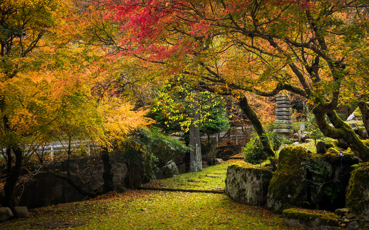
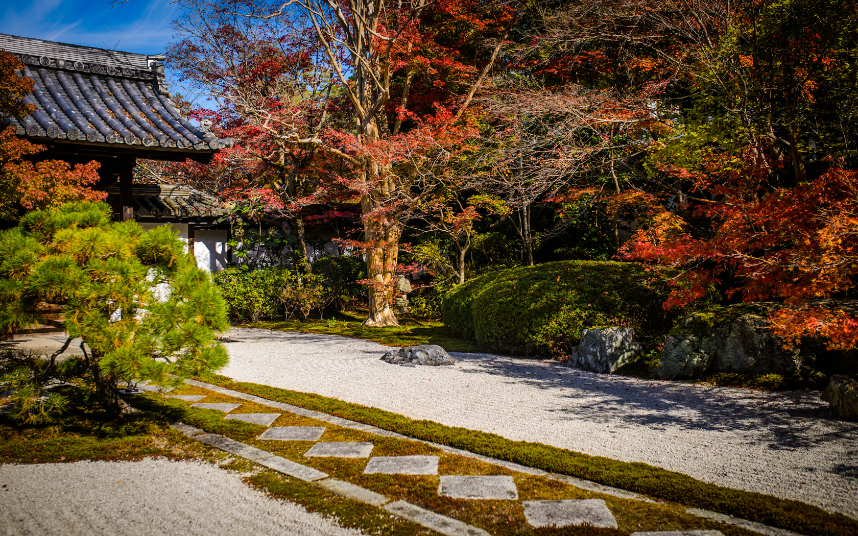
Hidden Treasure
photo from last fall
去年の秋
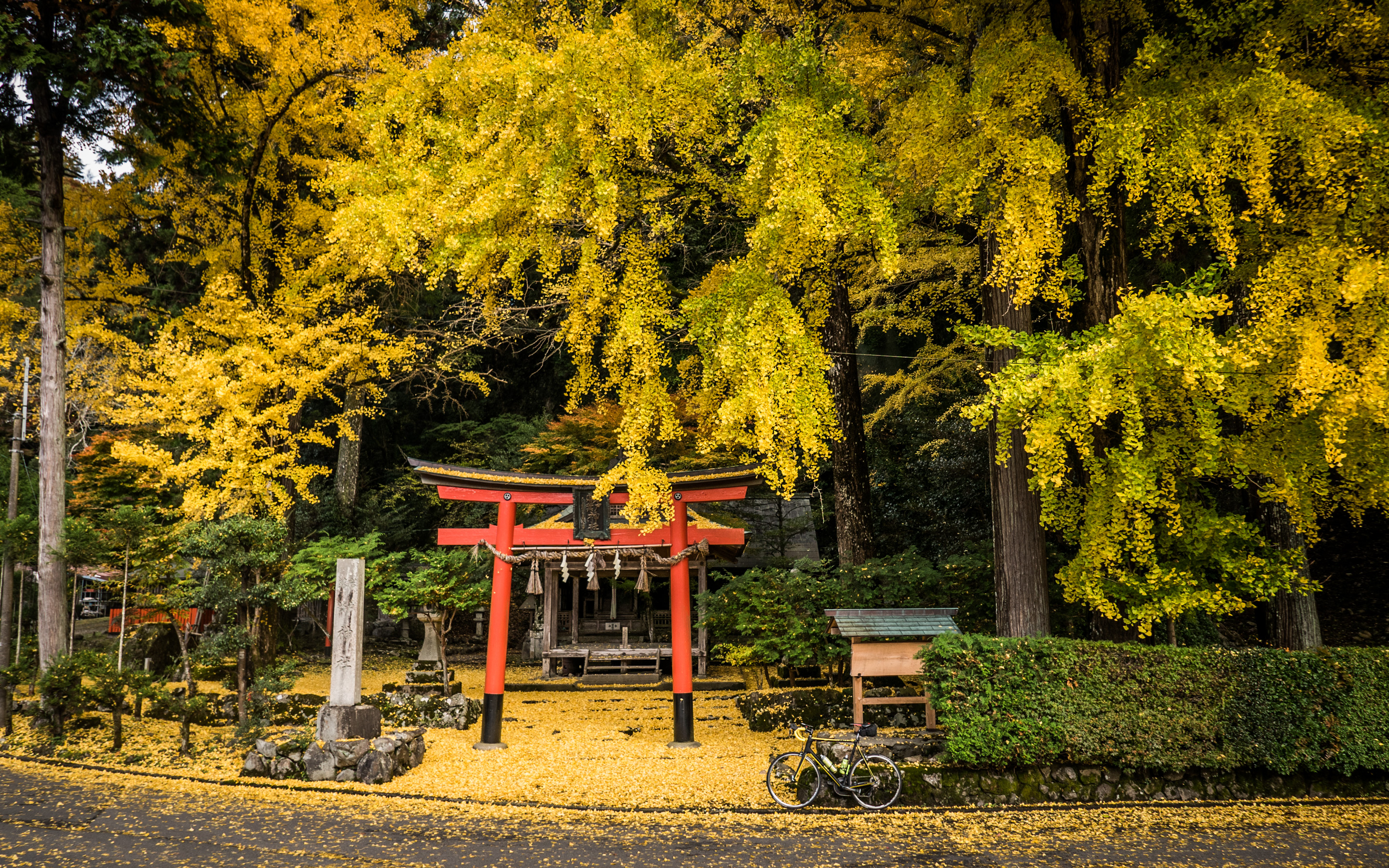
It's still six weeks before the fall colors arrive in Kyoto, so here's a look forward with a few shots from various outings last year.
My cycling buddies would be surprised to know that they likely pass this garden fairly often. (Those curious about the location can follow the map link under the photo).
今回の更新は去年の秋のいろいろ。

Nikon D4 + Nikkor 24mm f/1.4 — 1/400 sec, f/1.4, ISO 500 — map & image data — nearby photos
at the Enkoji Temple (円光寺)
 -- Kyoto, Japan -- Copyright 2015 Jeffrey Friedl, https://regex.info/blog/")
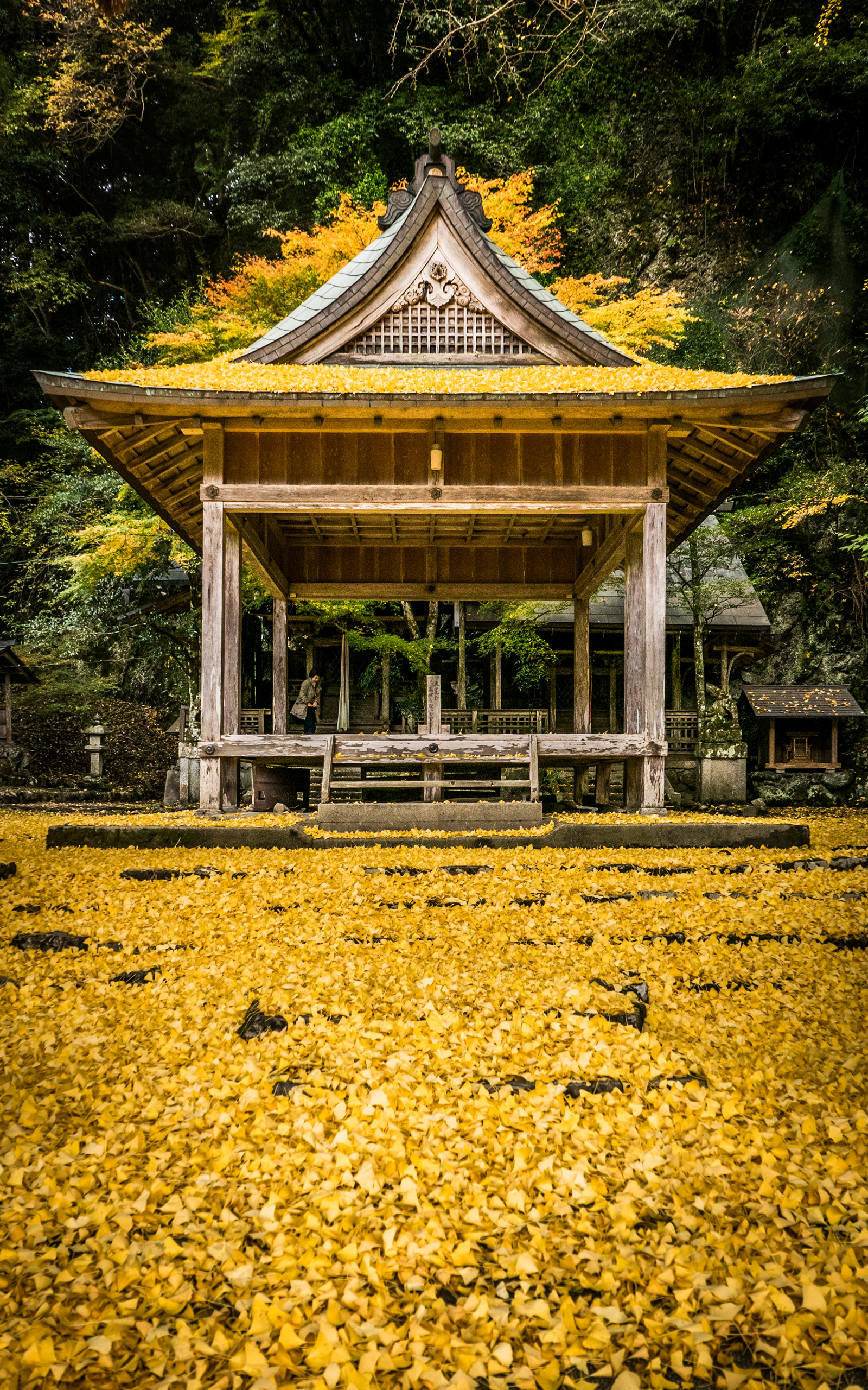
 -- Iwato Ochiba Shrine (岩戸落葉神社) -- Kyoto, Japan -- Copyright 2015 Jeffrey Friedl, https://regex.info/blog/ -- This photo is licensed to the public under the Creative Commons Attribution-NonCommercial 4.0 International License http://creativecommons.org/licenses/by-nc/4.0/ (non-commercial use is freely allowed if proper attribution is given, including a link back to this page on http://regex.info/ when used online)")
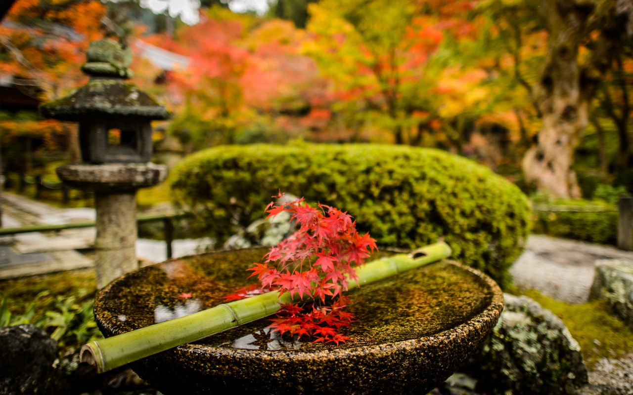
Panasonic LX100 at an effective 24mm — 1/125 sec, f/2.5, ISO 200 — map & image data — nearby photos
at the Iwato Ochiba Shrine (岩戸落葉神社)


Panasonic LX100 at an effective 24mm — 1/125 sec, f/1.7, ISO 200 — map & image data — nearby photos
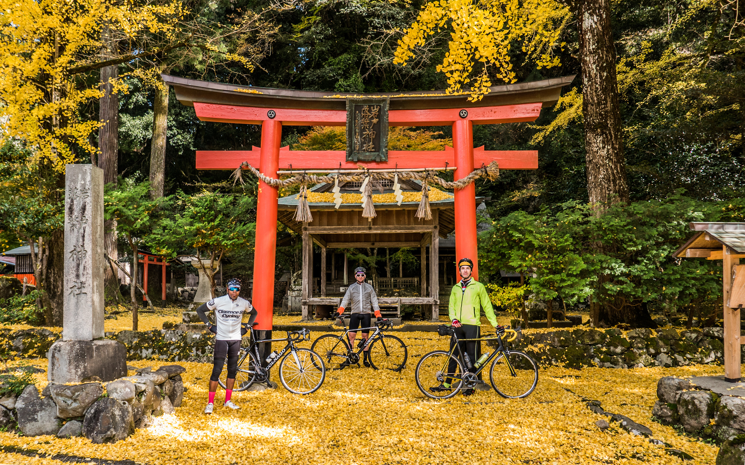
Roadside-Mirror Selfie
taken while on this ride

Panasonic LX100 at an effective 24mm — 1/125 sec, f/2.5, ISO 200 — map & image data — nearby photos
Random House's Yard
near the “Hidden Treasure” garden from the first photo

Panasonic LX100 at an effective 24mm — 1/125 sec, f/2.8, ISO 200 — map & image data — nearby photos
Back Here Again
with Michael and Andy

Nikon D4 + Sigma 35mm F1.4 DG HSM — 1/400 sec, f/3.5, ISO 110 — map & image data — nearby photos
Tenjuan Temple (天授庵)
on a washed-out bright day

 -- Enkoji Temple (円光寺) -- Kyoto, Japan -- Copyright 2015 Jeffrey Friedl, https://regex.info/blog/")
Nikon D4 + Nikkor 24mm f/1.4 — 1/400 sec, f/1.4, ISO 2200 — map & image data — nearby photos
Garden Viewing
at the Enkoji Temple (円光寺)
 -- Kyoto, Japan -- Copyright 2015 Jeffrey Friedl, https://regex.info/blog/")
Nikon D4 + Voigtländer 125mm f/2.5 — 1/400 sec, f/2.5, ISO 1250 — map & image data — nearby photos
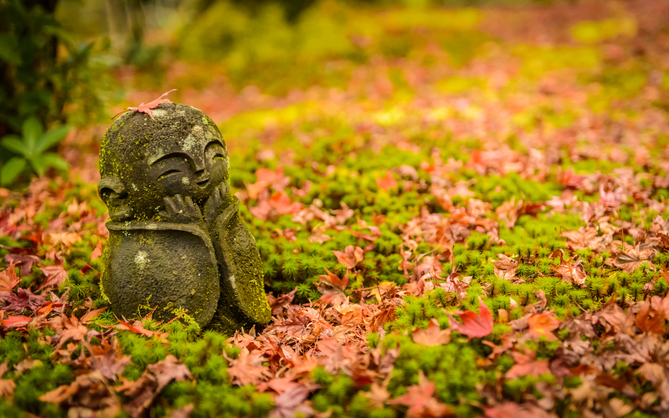
Photographing a Cute Little Statue

Nikon D4 + Nikkor 24-70mm f/2.8 @ 60mm — 1/400 sec, f/2.8, ISO 4000 — map & image data — nearby photos
My Turn
 -- Kyoto, Japan -- Copyright 2015 Jeffrey Friedl, https://regex.info/blog/")
Nikon D4 + Voigtländer 125mm f/2.5 — 1/400 sec, f/2.5, ISO 1600 — map & image data — nearby photos
Chimping
Other posts from the outings that these photos came from include:
- “Great Day in Kyoto’s Colorful Northern Mountains, and at Strava’s Kyoto Office”
- “Cycling to Kyoto’s Ochiba Shrine Amid the Fall Colors”
- “The Tenjuan Temple (Fall Colors and a Wigglegram)”
- “Wigglegram of a Pleasant Couple Among the Fall Colors at Kyoto’s Enkoji Temple”
 Otsu, Japan this past January / 今年の一月 -- Ishiyamadera (石山寺) -- Otsu, Shiga, Japan -- Copyright 2016 Jeffrey Friedl, https://regex.info/blog/")
Panasonic LX100 at an effective 24mm — 1/400 sec, f/1.7, ISO 200 — map & image data — nearby photos
Manseki and his New Friend
at the Ishiyama-dera Temple (石山寺)
Otsu, Japan
this past January / 今年の一月
今年の一月(八ヶ月前)、万石さんと万石さんの知り合い樋口さんとサイクリングをしました。 やっと記事をアップします。遠いの山田舎の息障寺まで行きました。
I'm finally getting around to post about a great day of cycling last January (8 months ago), with Manseki and an acquaintance of his, Higuchi-san, to a far-flung temple I knew of in the middle of nowhere.
We met up in front of the Ishiyama Temple in Otsu.
 -- Otsu, Shiga, Japan -- Copyright 2016 Jeffrey Friedl, https://regex.info/blog/")
Panasonic LX100 at an effective 24mm — 1/125 sec, f/3.5, ISO 200 — map & image data — nearby photos
Front Gate of the Ishiyama-dera Temple
石山寺の正門
It's a lovely, photogenic temple that I first visited four years ago, and now ride by fairly often.
It's perhaps difficult to see in the photo above, but just flanking either side of the entrance are huge bamboo New Year displays, the one on the right in the process of being dismantled. The main part of each display are three thick sections of bamboo, cut at a sharp angle...
 -- Otsu, Shiga, Japan -- Copyright 2016 Jeffrey Friedl, https://regex.info/blog/")
 -- Otsu, Shiga, Japan -- Copyright 2016 Jeffrey Friedl, https://regex.info/blog/")
 -- Otsu, Shiga, Japan -- Copyright 2016 Jeffrey Friedl, https://regex.info/blog/")
The mascot was there to meet a bus load of tourists who pulled up soon after this shot.
This front gate is next to the cafe we stopped by on one of my first long cycle rides the previous year. The owner is an avid cyclist, and through the owner, one of the waitresses got into cycling and today was our riding partner:
 -- Otsu, Shiga, Japan -- Copyright 2016 Jeffrey Friedl, https://regex.info/blog/")
Panasonic LX100 at an effective 38mm — 1/125 sec, f/2.8, ISO 200 — map & image data — nearby photos
Mrs. Higuchi
I've come across Higuchi-san in the mountains while cycling a couple of times, the first time noted here. This would be my first ride with her.
 -- Otsu, Shiga, Japan -- Copyright 2016 Jeffrey Friedl, https://regex.info/blog/")
Panasonic LX100 at an effective 28mm — 1/125 sec, f/5.6, ISO 200 — map & image data — nearby photos
Ready to Head Out

 -- Otsu, Shiga, Japan -- Copyright 2016 Jeffrey Friedl, https://regex.info/blog/")
Panasonic LX100 at an effective 24mm — 1/500 sec, f/2, ISO 200 — map & image data — nearby photos
Typical “Manseki Attack” Shot
similar to this shot
taken while cycling at 26 kph (16 mph)
 -- Otsu, Shiga, Japan -- Copyright 2016 Jeffrey Friedl, https://regex.info/blog/")
Panasonic LX100 at an effective 24mm — 1/500 sec, f/2, ISO 200 — map & image data — nearby photos
taken while cycling at 28 kph (17 mph)

Panasonic LX100 at an effective 33mm — 1/125 sec, f/2.2, ISO 200 — map & image data — nearby photos
Cresting a Hill
 -- Koka, Shiga, Japan -- Copyright 2016 Jeffrey Friedl, https://regex.info/blog/")
Panasonic LX100 at an effective 24mm — 1/125 sec, f/4.5, ISO 200 — map & image data — nearby photos
Impromptu Race
taken while cycling at 27 kph (17 mph)

Panasonic LX100 at an effective 33mm — 1/400 sec, f/5.6, ISO 200 — map & image data — nearby photos
Impromptu Photo Op

The pause above was 45km into the ride, just before the first big climb, the lovely but unpopular (because it's so far from populated areas, I suppose) Iwaosan Western Climb.

Panasonic LX100 at an effective 24mm — 1/125 sec, f/5.6, ISO 200 — map & image data — nearby photos
Black Ice
岩尾山へ登りはブラックアイスでした
It was cold enough in the mountains for ice to form on the roads, so any patch that looked wet was suspect. Occasionally the ice was obvious, where it formed on large puddles and broke as we rode through...

Panasonic LX100 at an effective 75mm — 1/160 sec, f/5.6, ISO 200 — map & image data — nearby photos
Easily-Visible Ice

Panasonic LX100 at an effective 24mm — 1/125 sec, f/5.6, ISO 800 — map & image data — nearby photos
Side Road to Explore Some Day
closed to motor vehicles, but fine by foot or bike

Panasonic LX100 at an effective 24mm — 1/125 sec, f/5.6, ISO 500 — map & image data — nearby photos
After the Climb
feeling in better shape than that old sign
 Descent taken while cycling at 16 kph (10 mph) -- Koka, Shiga, Japan -- Copyright 2016 Jeffrey Friedl, https://regex.info/blog/")
Panasonic LX100 at an effective 35mm — 1/125 sec, f/5.6, ISO 800 — map & image data — nearby photos
Scary (but Beautiful) Descent
taken while cycling at 16 kph (10 mph)
 -- Koka, Shiga, Japan -- Copyright 2016 Jeffrey Friedl, https://regex.info/blog/")
Panasonic LX100 at an effective 35mm — 1/125 sec, f/5.6, ISO 2000 — map & image data — nearby photos
Looks Icy
taken while cycling at 31 kph (19 mph)
 -- Koka, Shiga, Japan -- Copyright 2016 Jeffrey Friedl, https://regex.info/blog/")
Panasonic LX100 at an effective 24mm — 1/125 sec, f/5.6, ISO 2500 — map & image data — nearby photos
taken while cycling at 45 kph (28 mph)

Panasonic LX100 at an effective 24mm — 1/400 sec, f/5.6, ISO 200 — map & image data — nearby photos
Photo Op
taken by Manseki while I rode by
 -- Sokushoji (息障寺) -- Koka, Shiga, Japan -- Copyright 2016 Jeffrey Friedl, https://regex.info/blog/")
Panasonic LX100 at an effective 35mm — 1/125 sec, f/5.6, ISO 200 — map & image data — nearby photos
Arrived at the Temple
we arrived to the turn off to the temple, at least
Sokushoji Temple (息障寺)
From the “main” road (if it can be called that), the temple is a further 820m @ 9.2%.
 -- Koka, Shiga, Japan -- Copyright 2016 Jeffrey Friedl, https://regex.info/blog/")
Panasonic LX100 at an effective 50mm — 1/125 sec, f/5.6, ISO 1000 — map & image data — nearby photos
Powering Up
Few folks have done this by bicycle; Mrs. Higuchi and I got the QOM/KOM.
 -- Koka, Shiga, Japan -- Copyright 2016 Jeffrey Friedl, https://regex.info/blog/")
Panasonic LX100 at an effective 24mm — 1/125 sec, f/3.5, ISO 200 — map & image data — nearby photos
Arrival at the Parking Lot
This is the temple that appeared on my blog five years previous (has it been that long?!), in “Short Family Visit to the Middle-of-Nowhere Sokushouji Temple”, whose opening shot is taken from this parking log.
There's much to explore at this small temple, and one climb a huge flight of stairs to a wonderful viewpoint, but on this trip we just looked around at the base.
 -- Koka, Shiga, Japan -- Copyright 2016 Jeffrey Friedl, https://regex.info/blog/")
 -- Koka, Shiga, Japan -- Copyright 2016 Jeffrey Friedl, https://regex.info/blog/")
Panasonic LX100 at an effective 24mm — 1/125 sec, f/4.5, ISO 200 — map & image data — nearby photos
Buddies
photo by Yoshino Higuchi
 -- Koka, Shiga, Japan -- Copyright 2016 Jeffrey Friedl, https://regex.info/blog/")
Panasonic LX100 at an effective 24mm — 1/320 sec, f/5.6, ISO 200 — map & image data — nearby photos
Heading Back Down
We thought we'd try to take some “action” shots on the way down, but I'm still pretty bad at this kind of photography. I had Mrs. Higuchi ride up past me on the steepest hairpin, but you get no sense of the steepness nor the effort in the result....
 -- Koka, Shiga, Japan -- Copyright 2016 Jeffrey Friedl, https://regex.info/blog/")
Panasonic LX100 at an effective 24mm — 1/125 sec, f/1.7, ISO 250 — map & image data — nearby photos
Super Steep
take my word for it
We also tried some downhill shots. Manseki has a good sense for action shots, having done his share of photo shoots as a professional skier.
 -- Koka, Shiga, Japan -- Copyright 2016 Jeffrey Friedl, https://regex.info/blog/")
Panasonic LX100 at an effective 24mm — 1/125 sec, f/4, ISO 200 — map & image data — nearby photos
photo by Manseki Kanemitsu
I tried to mimic his technique.
 -- Koka, Shiga, Japan -- Copyright 2016 Jeffrey Friedl, https://regex.info/blog/")

Panasonic LX100 at an effective 24mm — 1/125 sec, f/8, ISO 2500 — map & image data — nearby photos
Bland
but somehow still lovely
 to go -- Iga, Mie, Japan -- Copyright 2016 Jeffrey Friedl, https://regex.info/blog/")
Panasonic LX100 at an effective 35mm — 1/250 sec, f/8, ISO 200 — map & image data — nearby photos
Heading Home
only about 65km (40mi) to go
We came across a road that looked quite inviting on the satellite view, but it turns out to be a private road up to an equestrian farm. (Manseki is apparently an accomplished rider, and knew of the property, but had never been there.)

Panasonic LX100 at an effective 35mm — 1/160 sec, f/5.6, ISO 200 — map & image data — nearby photos
In Front of a Lovely-Looking Road
that we couldn't take
We also came across a cafe that he had been to before, one in the middle of nowhere that routinely has hours-long lines form to get in, apparently. Luckily, we happened across it when almost no one was there.
 -- Mori Cafe (森のCafe) -- Koka, Shiga, Japan -- Copyright 2016 Jeffrey Friedl, https://regex.info/blog/")
Panasonic LX100 at an effective 24mm — 1/250 sec, f/5.6, ISO 200 — map & image data — nearby photos
Mori Cafe (森のCafe)
 -- Koka, Shiga, Japan -- Copyright 2016 Jeffrey Friedl, https://regex.info/blog/")
Panasonic LX100 at an effective 24mm — 1/125 sec, f/2.5, ISO 200 — map & image data — nearby photos
Pleasant
at least if you don't have to wait an hour

Panasonic LX100 at an effective 46mm — 1/160 sec, f/8, ISO 200 — map & image data — nearby photos
Why You Can't Always Trust Maps
short section of no-longer-maintained old road
 -- Koka, Shiga, Japan -- Copyright 2016 Jeffrey Friedl, https://regex.info/blog/")
Panasonic LX100 at an effective 27mm — 1/125 sec, f/2.2, ISO 200 — map & image data — nearby photos
Downhill
taken while cycling at 39 kph (24 mph)
 -- Otsu, Shiga, Japan -- Copyright 2016 Jeffrey Friedl, https://regex.info/blog/")
Panasonic LX100 at an effective 24mm — 1/125 sec, f/1.7, ISO 1000 — map & image data — nearby photos
taken while cycling at 35 kph (22 mph)
All in all, it was a great time. I'd like to try the first half of the route again when it's warmer. Maybe I'll put that at the top of my list once my injured calf heals.