 Kyoto Japan -- Kuginuki Jizo Temple (釘抜地蔵) -- Copyright 2015 Jeffrey Friedl, https://regex.info/blog/ -- This photo is licensed to the public under the Creative Commons Attribution-NonCommercial 4.0 International License http://creativecommons.org/licenses/by-nc/4.0/ (non-commercial use is freely allowed if proper attribution is given, including a link back to this page on http://regex.info/ when used online)")
Nikon D4 + 17-35mm f/2.8 @ 17mm — 1/80 sec, f/2.8, ISO 360 — map & image data — nearby photos
Kuginuki Jizo Temple (釘抜地蔵)
Kyoto Japan
Without question, the most unique and solemn temple I've ever come across in Japan is the small but emotionally-packed Kuginuki Jizo Temple here in Kyoto.
今まで出会ったお寺の中で、一番面白いな、いかめしいお寺は京都にある釘抜地蔵です。 日本語で説明は難しいですが、ウィキペディアでは説明があるはず。
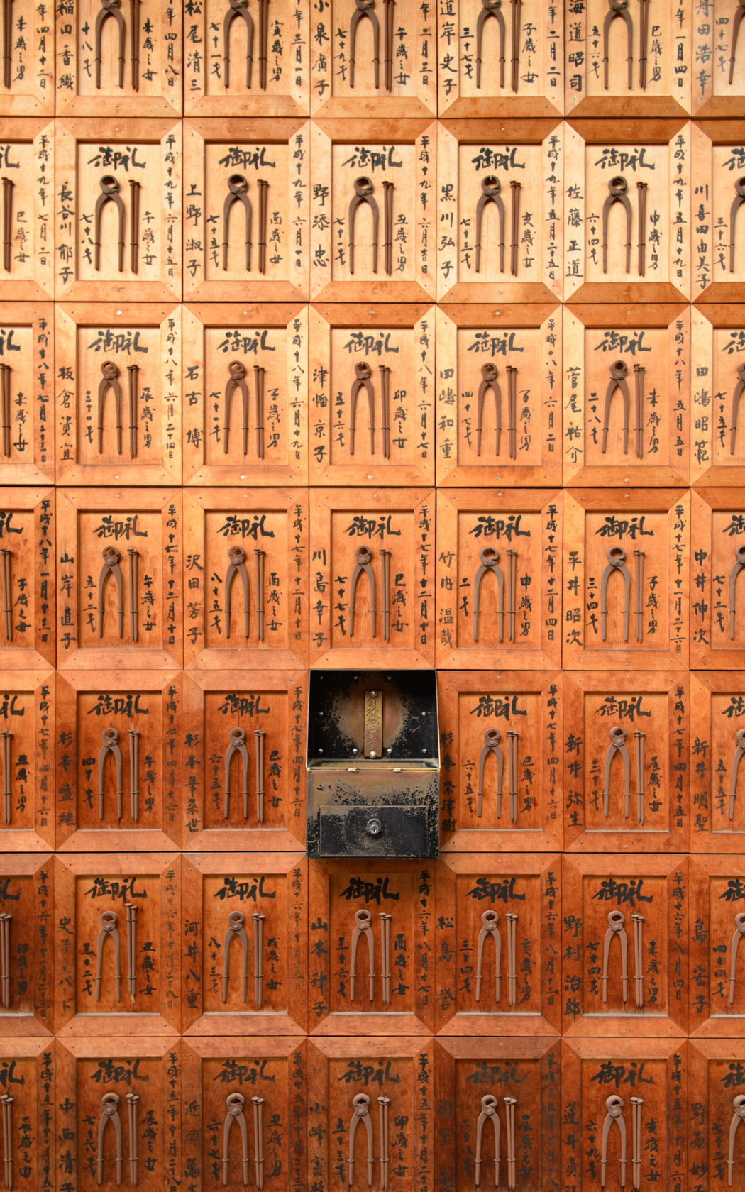
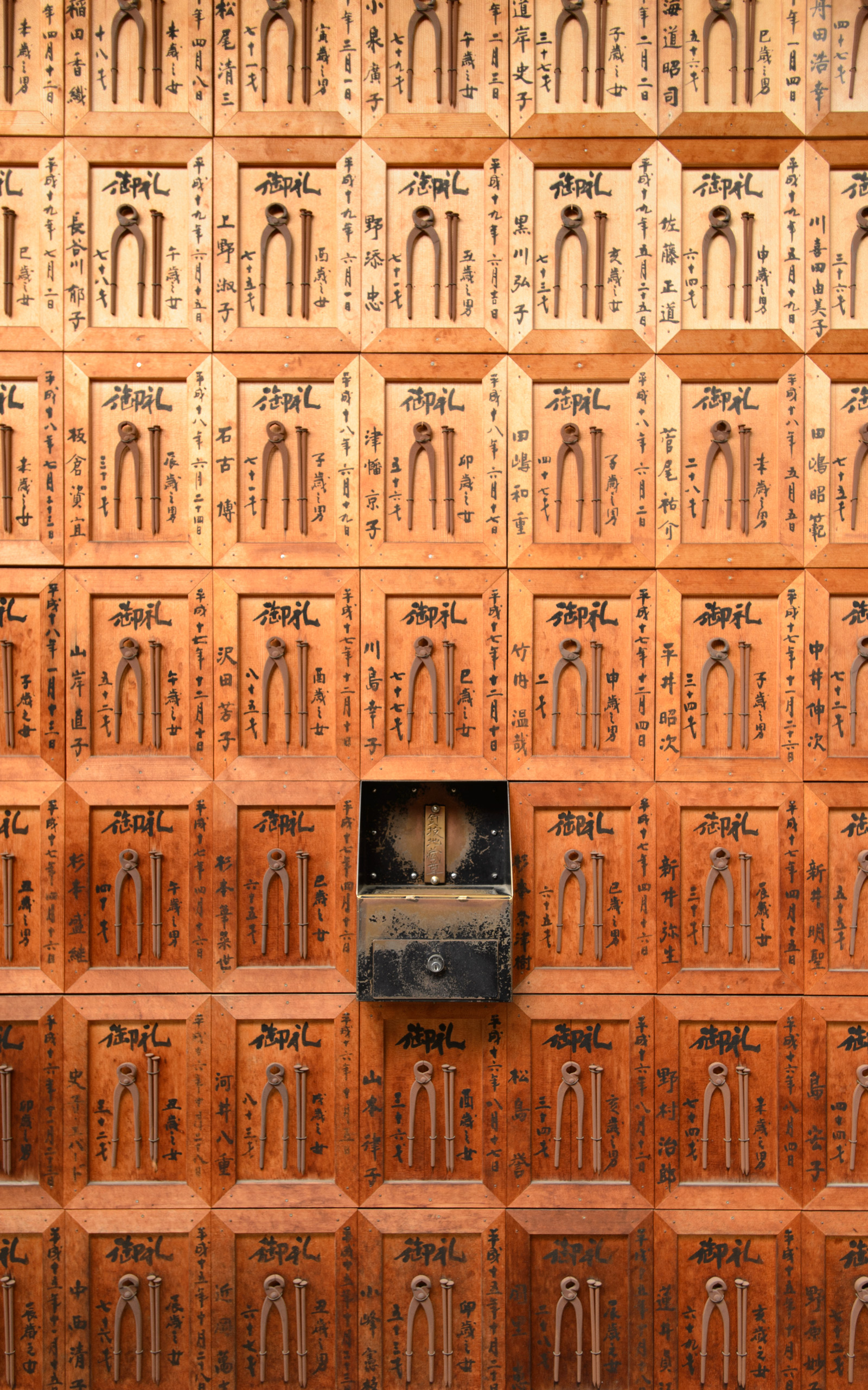
Its official name is The Shakushoji Temple (石像寺), but its name in the local vernacular, kuginuki jizou (more or less “nail-pulling guardian deity”) reflects the images of nail and spike pullers that permeate the temple grounds...
 in Kyoto Japan")
Nikon D4 + 17-35mm f/2.8 @ 35mm — 1/160 sec, f/2.8, ISO 360 — map & image data — nearby photos
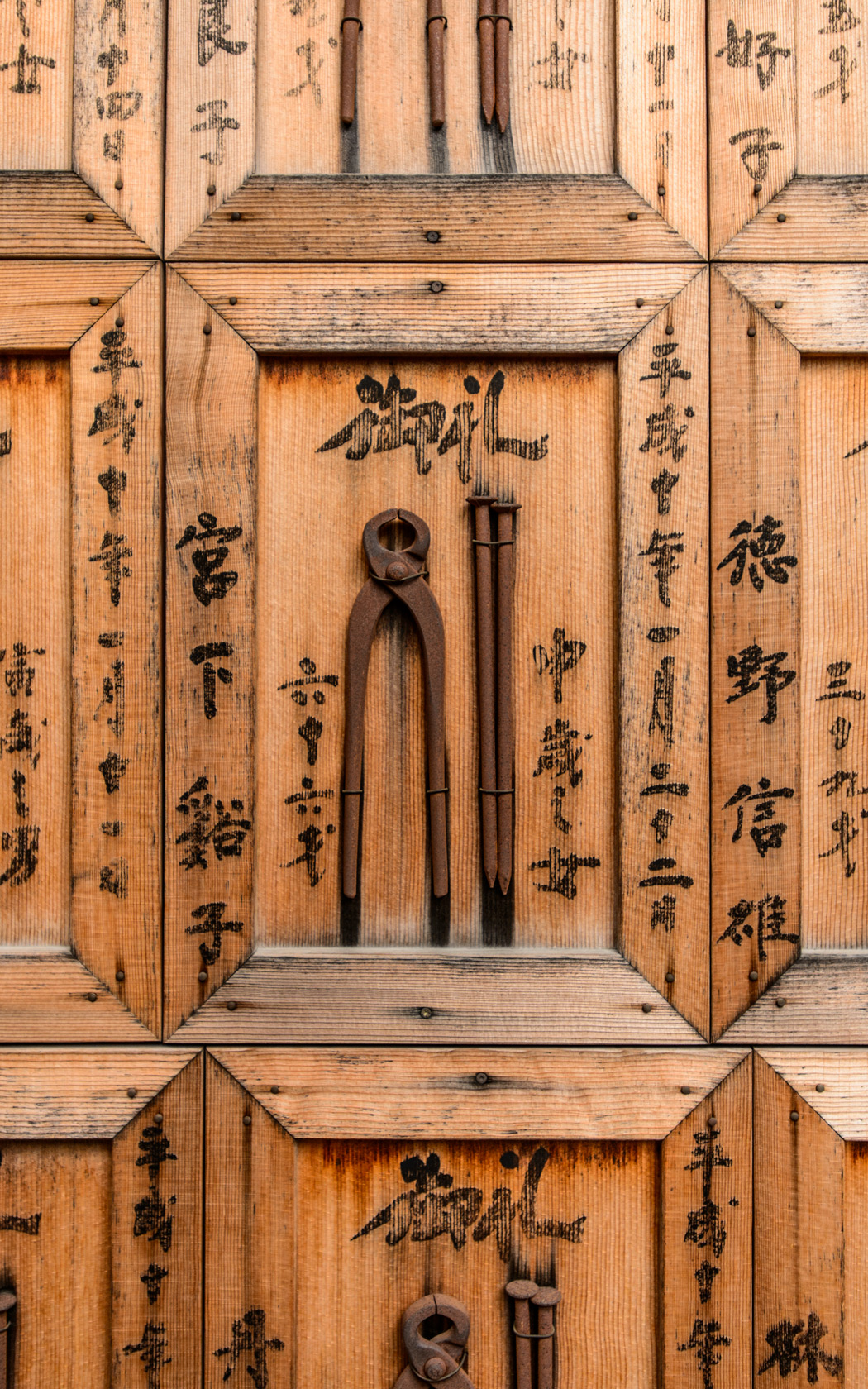
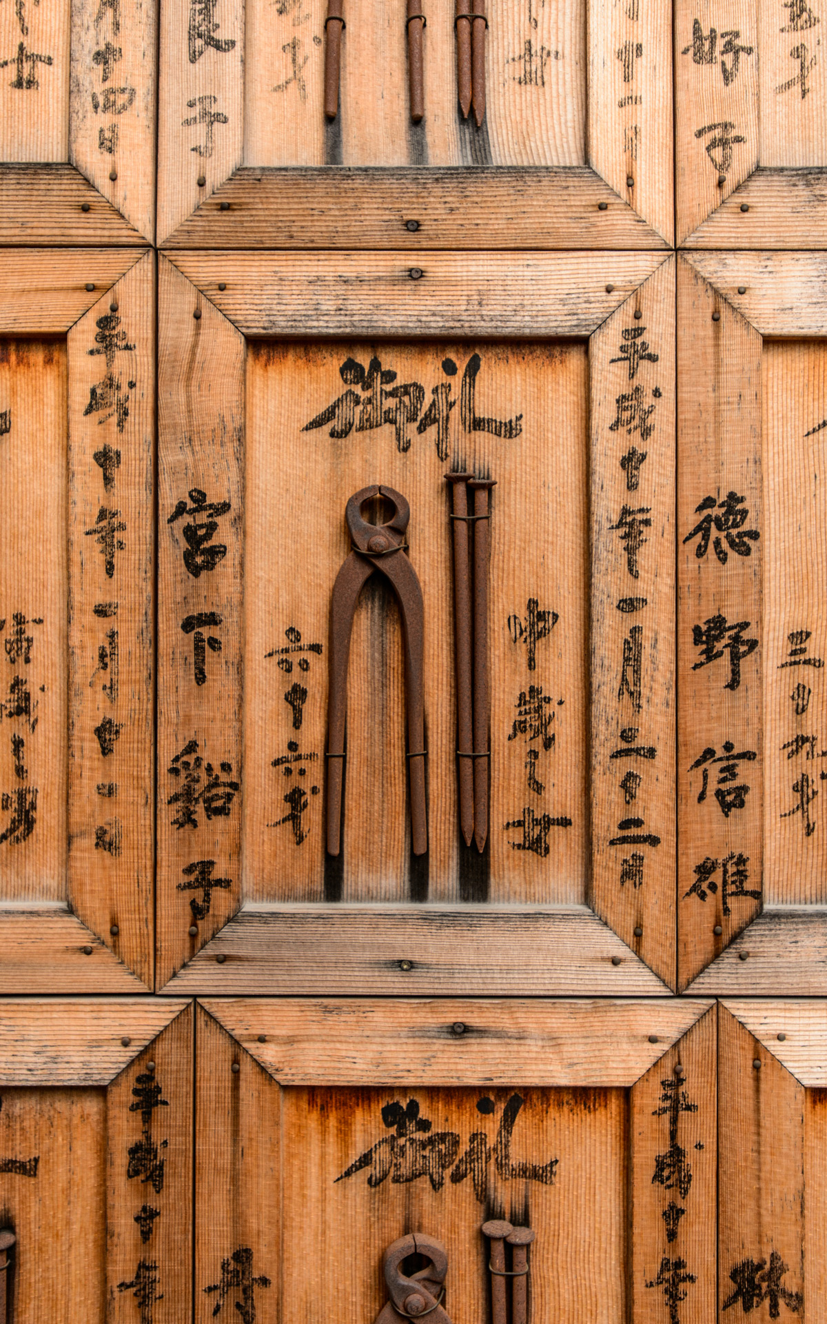
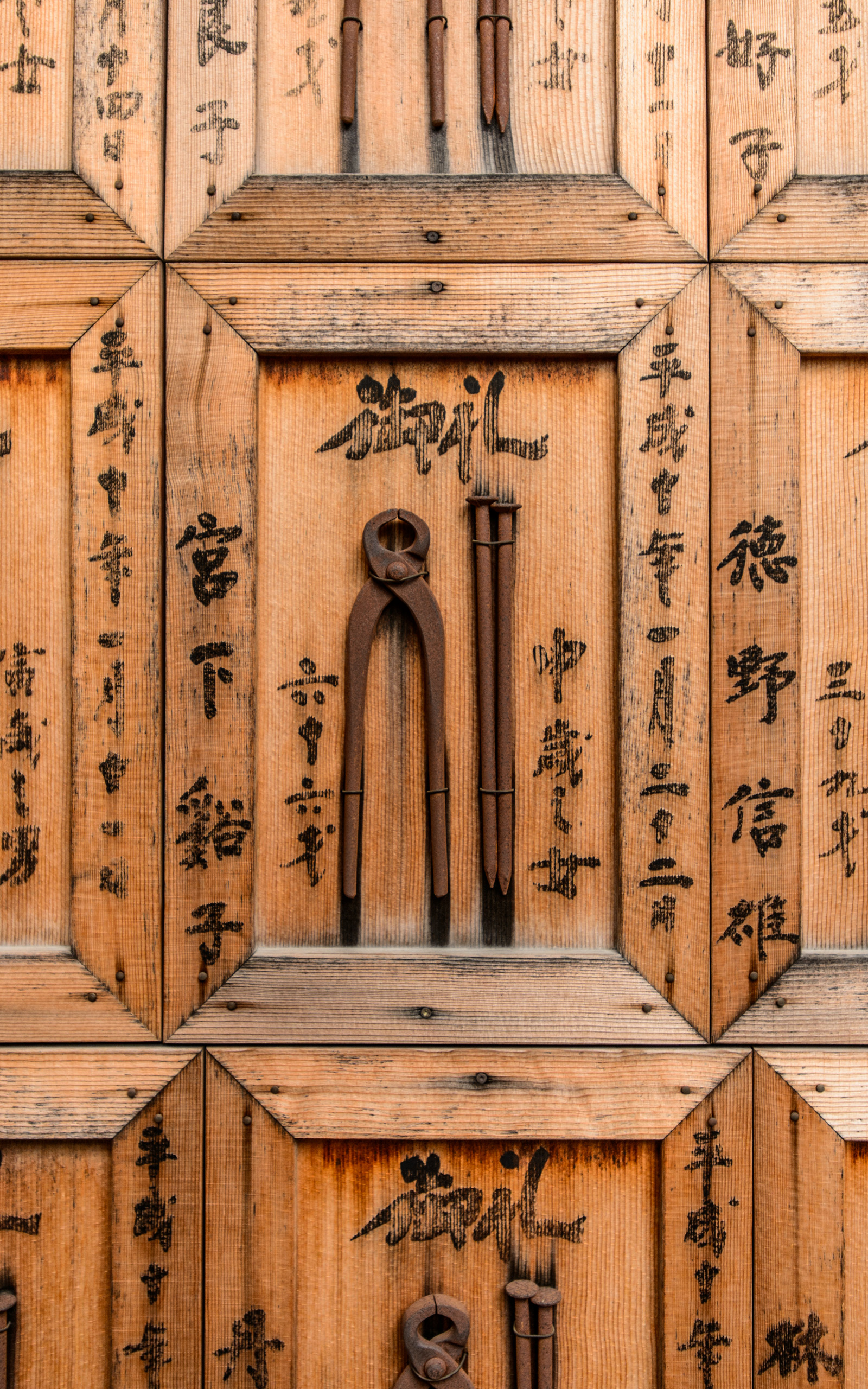
Wall Detail
nail puller and nails
Until you understand the meaning behind it, it certainly feels quite odd. But once you understand the meaning (which we'll get to below), you'll understand why the temple is so solemn.
 -- Kyoto, Japan -- Copyright 2015 Jeffrey Friedl, https://regex.info/blog/ -- This photo is licensed to the public under the Creative Commons Attribution-NonCommercial 4.0 International License http://creativecommons.org/licenses/by-nc/4.0/ (non-commercial use is freely allowed if proper attribution is given, including a link back to this page on http://regex.info/ when used online)")
Nikon D4 + Nikkor 50mm f/1.4 — 1/200 sec, f/2.2, ISO 100 — map & image data — nearby photos
Huge Puller for Railroad Spikes
or the like; it's about four feet tall
As is common with jizo statues (like these), this spike puller has a little bib.
 -- Kyoto, Japan -- Copyright 2015 Jeffrey Friedl, https://regex.info/blog/ -- This photo is licensed to the public under the Creative Commons Attribution-NonCommercial 4.0 International License http://creativecommons.org/licenses/by-nc/4.0/ (non-commercial use is freely allowed if proper attribution is given, including a link back to this page on http://regex.info/ when used online)")
Nikon D4 + Nikkor 50mm f/1.4 — 1/640 sec, f/1.4, ISO 100 — map & image data — nearby photos
Entrance from the Street
with its “shrine name” 家隆山
The temple is in the middle of what is now urban city, with its only exposure to the street being a small unassuming entrance. You could walk by this place every day and never notice it.
The red lanterns across the top have the common name of the temple (釘抜地蔵尊), while the beautifully carved wood with golden lettering has the “mountain name” for the temple, 家隆山 (karyuzan).
This “mountain name” business is a bit interesting, and I didn't understood it until a month or so ago when it was explained to me by the lady of the temple at the Shimyouin Temple (志明院) when I stopped by during a bicycle ride....
Sidebar: Temples, Shrines, and Shrines in Temples....
Japan has a lot of temples and shrines, with temples being related to Buddhism and shrines related to Shintoism — distinct religions — but all temples in Japan have a long official name with a sub-name that includes a reference to “mountain”, even if the temple is located in a completely flat area. This might be considered an ancient marketing technique to help the Buddhist temple appeal to Shinto followers: in Shinto, mountains have a “spirit” to be respected, and so temples include a small shrine with a mountain name.
The “mountain name” for the famous Kiyomizu Temple, for example, is otowayama (音羽山). There's actually a mountain of that name 10km (6mi) away (which I rode to the top by bicycle recently), but I don't know whether or how they might be related. (Update: they used to be sister temples, but, I'm told, the bigger and more-popular Kiyomizu temple pulled out of the larger temple group because it didn't want to pay a percent of its income to the group.)
 -- Kyoto, Japan -- Copyright 2015 Jeffrey Friedl, https://regex.info/blog/ -- This photo is licensed to the public under the Creative Commons Attribution-NonCommercial 4.0 International License http://creativecommons.org/licenses/by-nc/4.0/ (non-commercial use is freely allowed if proper attribution is given, including a link back to this page on http://regex.info/ when used online)")
Nikon D4 + Nikkor 50mm f/1.4 — 1/1600 sec, f/1.4, ISO 100 — map & image data — nearby photos
Stone Wheel
I don't know the purpose of the stone wheel along the entrance path, but I have a hunch it's related to prayer wheels.
 -- Kyoto, Japan -- Copyright 2015 Jeffrey Friedl, https://regex.info/blog/ -- This photo is licensed to the public under the Creative Commons Attribution-NonCommercial 4.0 International License http://creativecommons.org/licenses/by-nc/4.0/ (non-commercial use is freely allowed if proper attribution is given, including a link back to this page on http://regex.info/ when used online)")
Nikon D4 + 17-35mm f/2.8 @ 17mm — 1/500 sec, f/2.8, ISO 100 — map & image data — nearby photos
Inside
 -- Kyoto, Japan -- Copyright 2015 Jeffrey Friedl, https://regex.info/blog/ -- This photo is licensed to the public under the Creative Commons Attribution-NonCommercial 4.0 International License http://creativecommons.org/licenses/by-nc/4.0/ (non-commercial use is freely allowed if proper attribution is given, including a link back to this page on http://regex.info/ when used online)")
Nikon D4 + 17-35mm f/2.8 @ 35mm — 1/160 sec, f/2.8, ISO 180 — map & image data — nearby photos
Deeply Meaningful
long moment in prayer
 -- Kyoto, Japan -- Copyright 2015 Jeffrey Friedl, https://regex.info/blog/ -- This photo is licensed to the public under the Creative Commons Attribution-NonCommercial 4.0 International License http://creativecommons.org/licenses/by-nc/4.0/ (non-commercial use is freely allowed if proper attribution is given, including a link back to this page on http://regex.info/ when used online)")
Nikon D4 + Nikkor 50mm f/1.4 — 1/800 sec, f/2.2, ISO 100 — map & image data — nearby photos
What He Was Grasping
this donated statue is dated 1964
So here's the meaning behind the nail/spike pullers...
Some emotional or physical pains are so intense that they feel like a spike through the heart, so you come here to pray that the spike be removed.
It's a simple concept made all the more meaningful by the mood at the temple. It has absolutely no feeling of showy trappings catering to the tourist; it was a 100% low-key local temple for the benefit of those who visit. In my visits, I've never seen a tourist (other than myself and those I brought). It's not that kind of place.
Despite no tourists, the patronage was lively, with visitors seemingly split into two groups: those visiting it simply as their local temple, and those visiting it for its specific spike-pulling specialty.
Because of the delicate nature of that latter group, I took care not to photograph people's faces, and went out of my way to not make people feel they were being watched by the camera. Someone dealing with death or illness or heartbreak comes here for emotional salve, not to be featured on my blog.
If you visit, please take care to be on your most humble, respectful, least-intrusive behavior.
The vibe at this place is so unique and wonderful that I seriously considered whether I should even post about it, worrying that loud touristy visitors could destroy the mood. Folks who read my blog have, by definition, class and good taste 😉, so hopefully it's not a problem.
It's always good to keep in mind when visiting any temple or shine (or church or synagogue or mosque, etc.) that even though it may not be a religious place for you, it is exactly that for some others, so conduct yourself accordingly.
 -- Kyoto, Japan -- Copyright 2015 Jeffrey Friedl, https://regex.info/blog/ -- This photo is licensed to the public under the Creative Commons Attribution-NonCommercial 4.0 International License http://creativecommons.org/licenses/by-nc/4.0/ (non-commercial use is freely allowed if proper attribution is given, including a link back to this page on http://regex.info/ when used online)")
Nikon D4 + 17-35mm f/2.8 @ 17mm — 1/80 sec, f/2.8, ISO 160 — map & image data — nearby photos
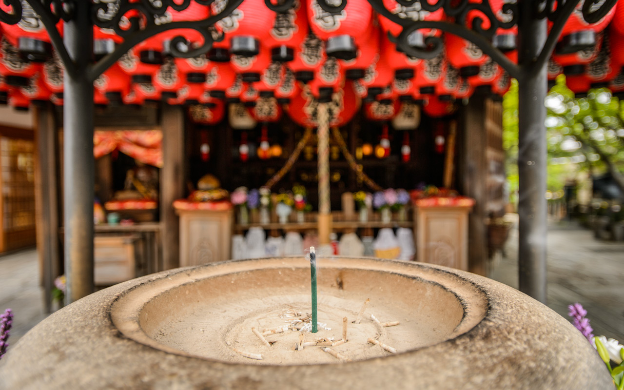
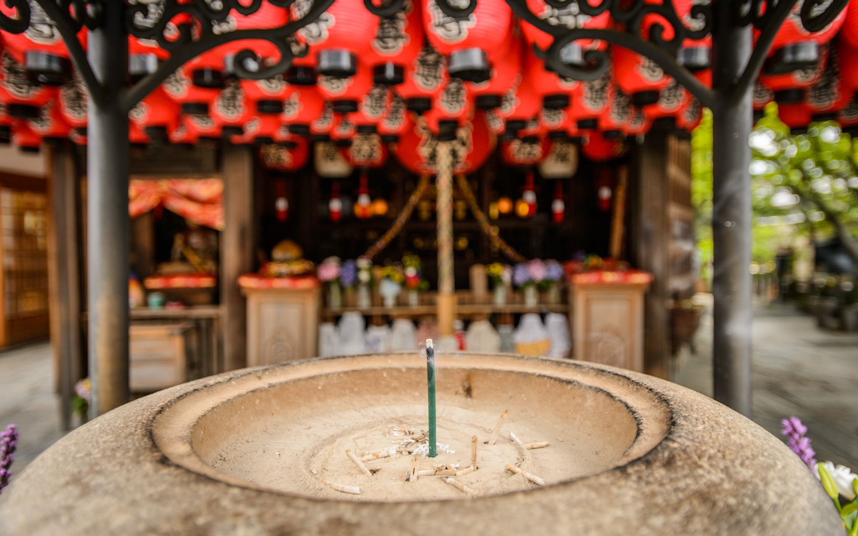
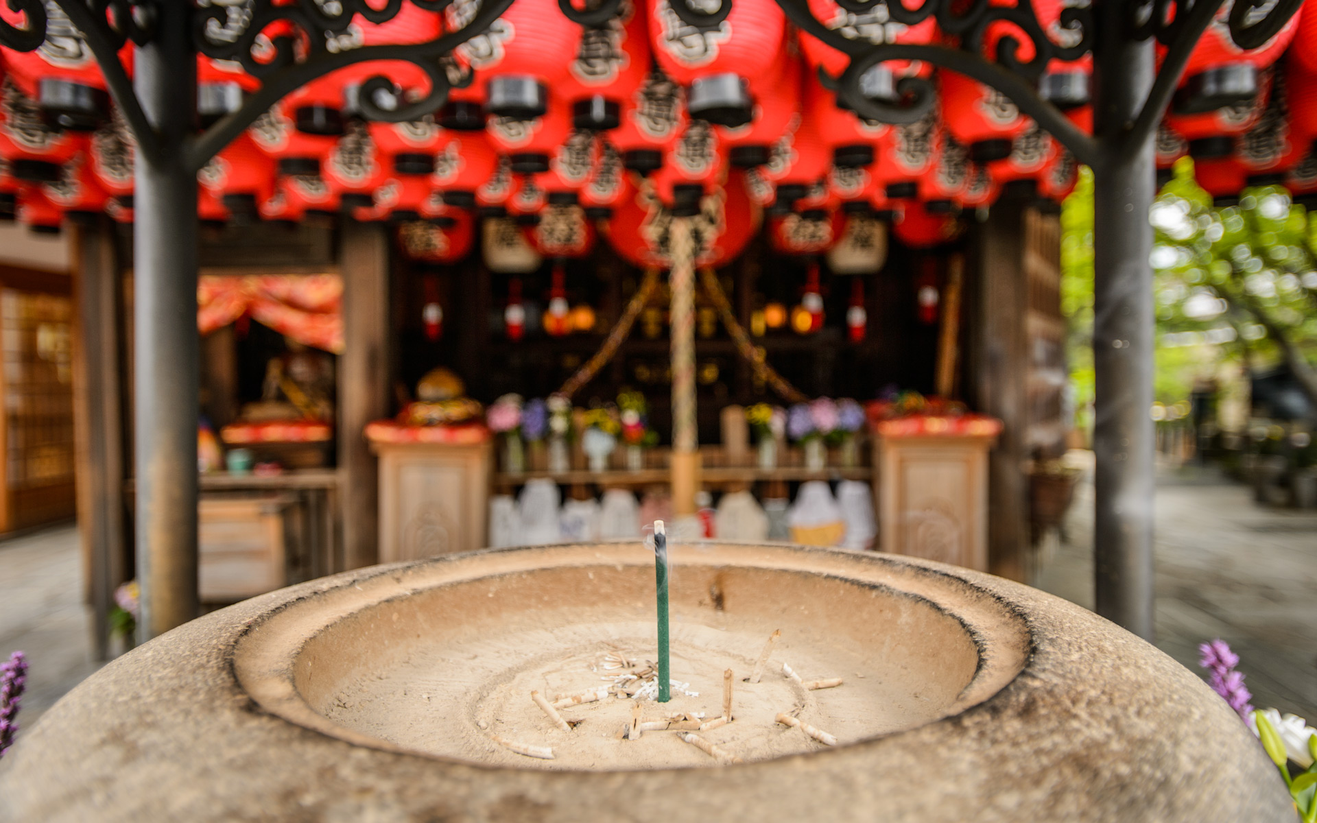
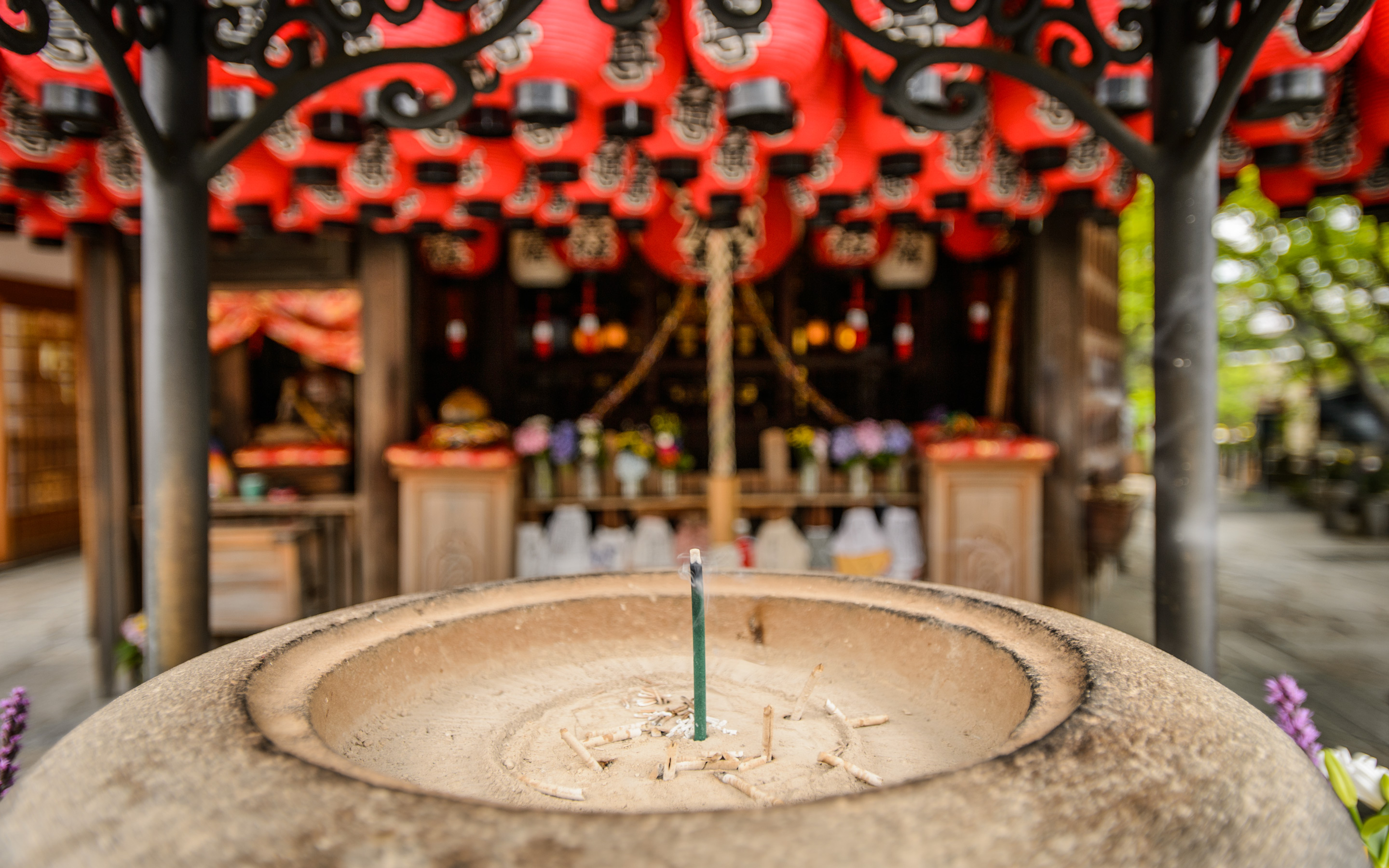
Even The Incense Basin
has an engraved spike puller
The temple itself apparently dates from about 1,200 years ago, but according to the story given on its Wikipedia page, the nail-pulling aspect is only four or five hundred years old. The story given there is that there was a merchant with intense pain in his hands that nothing could cure. He prayed intently here for a week, after which he was visited in a dream by the guardian deity and told that his pain came from someone in a past life with a grudge, placing a curse on him by driving huge spikes into a voodoo doll representing the merchant. As evidence, the deity showed the merchant the spikes. When he awoke from the dream, his pain was gone (the spikes having been removed and all).
 in Kyoto Japan")
 -- Kyoto, Japan -- Copyright 2015 Jeffrey Friedl, https://regex.info/blog/ -- This photo is licensed to the public under the Creative Commons Attribution-NonCommercial 4.0 International License http://creativecommons.org/licenses/by-nc/4.0/ (non-commercial use is freely allowed if proper attribution is given, including a link back to this page on http://regex.info/ when used online)")
Nikon D4 + 17-35mm f/2.8 @ 17mm — 1/80 sec, f/2.8, ISO 250 — map & image data — nearby photos
Photogenic Lanterns
in front of the main altar
 -- Kyoto, Japan -- Copyright 2015 Jeffrey Friedl, https://regex.info/blog/ -- This photo is licensed to the public under the Creative Commons Attribution-NonCommercial 4.0 International License http://creativecommons.org/licenses/by-nc/4.0/ (non-commercial use is freely allowed if proper attribution is given, including a link back to this page on http://regex.info/ when used online)")
Nikon D4 + 17-35mm f/2.8 @ 20mm — 1/80 sec, f/2.8, ISO 100 — map & image data — nearby photos
Wall of Offerings
 -- Kyoto, Japan -- Copyright 2015 Jeffrey Friedl, https://regex.info/blog/ -- This photo is licensed to the public under the Creative Commons Attribution-NonCommercial 4.0 International License http://creativecommons.org/licenses/by-nc/4.0/ (non-commercial use is freely allowed if proper attribution is given, including a link back to this page on http://regex.info/ when used online)")
Nikon D4 + 17-35mm f/2.8 @ 17mm — 1/80 sec, f/2.8, ISO 180 — map & image data — nearby photos
Making the Rounds
The main devotional action at the temple involves walking around the small central building. First you collect a number of bamboo sticks equal to your age...
 -- Kyoto, Japan -- Copyright 2015 Jeffrey Friedl, https://regex.info/blog/ -- This photo is licensed to the public under the Creative Commons Attribution-NonCommercial 4.0 International License http://creativecommons.org/licenses/by-nc/4.0/ (non-commercial use is freely allowed if proper attribution is given, including a link back to this page on http://regex.info/ when used online)")
Nikon D4 + Nikkor 50mm f/1.4 — 1/200 sec, f/1.6, ISO 500 — map & image data — nearby photos
Box of Bamboo Sticks
each with the name and age of someone who donated it as an offering
So, if you're 77 years old, you collect 77 sticks.
You then walk around the building, and when you get to the back wall, you touch a special something (I don't know what it is)...
 -- Kyoto, Japan -- Copyright 2015 Jeffrey Friedl, https://regex.info/blog/ -- This photo is licensed to the public under the Creative Commons Attribution-NonCommercial 4.0 International License http://creativecommons.org/licenses/by-nc/4.0/ (non-commercial use is freely allowed if proper attribution is given, including a link back to this page on http://regex.info/ when used online)")
Nikon D4 + 17-35mm f/2.8 @ 17mm — 1/125 sec, f/2.8, ISO 100 — map & image data — nearby photos
Back Wall
 in Kyoto Japan")
Nikon D4 + 17-35mm f/2.8 @ 28mm — 1/125 sec, f/2.8, ISO 450 — map & image data — nearby photos
Back-Wall Detail
In the photo above, you can see the vertical bar has had the paint long worn away. That's where folks touch on the way by. In practice, I saw some folks just stroll by without touching, while others stopped and clasped their hands together in prayer.
As you continue your way around the building, you drop on stick back into the box as you go by, and start over again with another trip around the building, continuing in this manner until the sticks are gone. So, in total, you make as many circuits as your age.
The temple grounds are quite small, but feel big with as much detail as they have packed into them. There are numerous little side areas for devotion...
 -- Kyoto, Japan -- Copyright 2015 Jeffrey Friedl, https://regex.info/blog/ -- This photo is licensed to the public under the Creative Commons Attribution-NonCommercial 4.0 International License http://creativecommons.org/licenses/by-nc/4.0/ (non-commercial use is freely allowed if proper attribution is given, including a link back to this page on http://regex.info/ when used online)")
Nikon D4 + 17-35mm f/2.8 @ 17mm — 1/80 sec, f/5.6, ISO 3200 — map & image data — nearby photos
“Traditional” Stone Jizo
 -- Kyoto, Japan -- Copyright 2015 Jeffrey Friedl, https://regex.info/blog/ -- This photo is licensed to the public under the Creative Commons Attribution-NonCommercial 4.0 International License http://creativecommons.org/licenses/by-nc/4.0/ (non-commercial use is freely allowed if proper attribution is given, including a link back to this page on http://regex.info/ when used online)")
 -- Kyoto, Japan -- Copyright 2015 Jeffrey Friedl, https://regex.info/blog/ -- This photo is licensed to the public under the Creative Commons Attribution-NonCommercial 4.0 International License http://creativecommons.org/licenses/by-nc/4.0/ (non-commercial use is freely allowed if proper attribution is given, including a link back to this page on http://regex.info/ when used online)")
Nikon D4 + 17-35mm f/2.8 @ 17mm — 1/80 sec, f/8, ISO 4500 — map & image data — nearby photos
Main Altar
 -- Kyoto, Japan -- Copyright 2015 Jeffrey Friedl, https://regex.info/blog/ -- This photo is licensed to the public under the Creative Commons Attribution-NonCommercial 4.0 International License http://creativecommons.org/licenses/by-nc/4.0/ (non-commercial use is freely allowed if proper attribution is given, including a link back to this page on http://regex.info/ when used online)")
Nikon D4 + 17-35mm f/2.8 @ 22mm — 1/100 sec, f/2.8, ISO 900 — map & image data — nearby photos
Cute Corner Cozies
on the head-high pointy end of a tin roof
 -- Kyoto, Japan -- Copyright 2015 Jeffrey Friedl, https://regex.info/blog/ -- This photo is licensed to the public under the Creative Commons Attribution-NonCommercial 4.0 International License http://creativecommons.org/licenses/by-nc/4.0/ (non-commercial use is freely allowed if proper attribution is given, including a link back to this page on http://regex.info/ when used online)")
Nikon D4 + 17-35mm f/2.8 @ 17mm — 1/80 sec, f/8, ISO 2800 — map & image data — nearby photos
Patchwork Wall
 -- Kyoto, Japan -- Copyright 2015 Jeffrey Friedl, https://regex.info/blog/ -- This photo is licensed to the public under the Creative Commons Attribution-NonCommercial 4.0 International License http://creativecommons.org/licenses/by-nc/4.0/ (non-commercial use is freely allowed if proper attribution is given, including a link back to this page on http://regex.info/ when used online)")
Nikon D4 + Nikkor 50mm f/1.4 — 1/200 sec, f/7.1, ISO 1000 — map & image data — nearby photos
Working Well
this deep well was just a source of water
for cleaning, watering plants, etc
I think this is the first working well I've ever seen.
It's a unique place and truly worth a visit if you can be sure not to disturb the ambiance. The entrance is here.
 1:35 pm (from the start of the ride: 9h 11m / 107 km / 66.4 miles) -- Shirahama Beach (白浜海水浴場) -- Takahama, Fukui, Japan -- Copyright 2015 Jeffrey Friedl, https://regex.info/blog/")
Panasonic LX100 at an effective 46mm — 1/125 sec, f/10, ISO 200 — map & image data — nearby photos
Fruits of My Recent Bicycle Ride
Shirahama Beach, Takahama Village, Fukui Prefecture (福井県高浜町の白浜海水浴場)
1:35 pm (from the start of the ride: 9h 11m / 107 km / 66.4 miles)
Tuesday was the “Sea Day” holiday in Japan, so I took the opportunity to make my first bicycle ride to the sea. Kyoto is about as far from the sea as a big city gets in Japan, so even though I've been to a lake that looks like an ocean, I'd not yet been by bicycle to the actual ocean.
この間のは海の日で初めての海までのサイクリングをしました、京都市内から。二時間の帰り電車を含めて17時間掛かりました。157キロを走って、一番山が多い道を選びました。 獲得高度は2,800mでした。 楽しかった。
 4:32 pm (from the start of the ride: 12h 8m / 145 km / 90.3 miles) photo by Antti -- Mermaid Beach (人魚の浜海水浴場) -- Obama, Fukui, Japan -- Copyright 2015 Jeffrey Friedl, https://regex.info/blog/")
Panasonic LX100 at an effective 24mm — 1/4000 sec, f/2.8, ISO 200 — map & image data — nearby photos
Me and the Mermaids
Mermaid Beach, Obama Japan (人魚の浜、福井県小浜市)
4:32 pm (from the start of the ride: 12h 8m / 145 km / 90.3 miles)
photo by Antti
It was a long trip.
I left the house at 4:24am, and returned 17 hours later at 9:33pm, though two hours of that was the return from the ocean by train. All in all it was 151km (94 miles) of cycling to and along the ocean, followed by a train back to Kyoto, then another 6km (4mi) of cycling from Kyoto Station to home.
Befitting the length of the trip, this post is also long.
I was joined by Antti, whom we saw shining in this day of mishaps last month, and Eric Findlay, who I'd run into by chance the day after that ride when he recognized me from my blog while we were both at the same bicycle shop.
We met at 4:30am in the early-morning dusk (sunrise was 4:58am) and headed north towards the mountains. Before diving into the mountains for the real climbs of the trip, we stopped at a convenience store that would be our last access to food for about five hours...
 Ichihara Lawsons (ローソン 静市市原) -- Ichihara Lawsons (ローソン 静市市原) -- Kyoto, Japan -- Copyright 2015 Jeffrey Friedl, https://regex.info/blog/")
Panasonic LX100 at an effective 24mm — 1/125 sec, f/4.5, ISO 200 — map & image data — nearby photos
5am Selfie
5:08 am (from start: 44 min / 11 km / 7.1 miles)
Ichihara Lawsons (ローソン 静市市原)
 -- Ichihara Lawsons (ローソン 静市市原) -- Kyoto, Japan -- Copyright 2015 Jeffrey Friedl, https://regex.info/blog/")
Panasonic LX100 at an effective 24mm — 1/125 sec, f/2.5, ISO 200 — map & image data — nearby photos
Eric Cooling Off
having just poured refrigerated water over his head
( it was already hot at 5 am )
I picked a route with as many mountain passes as I could fit in... Hanase Pass (花背峠/760m/2500'), Sasari Pass (佐々里峠/739m/2400'), Gonami Pass (五波峠/656m/2200'), and two smaller unnamed passes.
With this in mind, I took it easy going up the first and biggest climb of the day, Hanase, only to be shocked the next day when looking at the stats for that climb that I missed my PR (34:20) by only 10 seconds. Not only wasn't I trying, the road in many places was a shallow river due to runoff from a typhoon that had hit two days prior, and one can feel the slowdown as the tires have to cut through the water.
I did keep the camera in the back bag instead of around my neck, so perhaps that sped me up a bit.
Antti wasn't even trying either, it seems, since his time was almost 5 minutes slower than his best, but even then he was 2½ minutes faster than me.
 taken while cycling at 20 kph (12 mph) -- Kyoto, Japan -- Copyright 2015 Jeffrey Friedl, https://regex.info/blog/")
Panasonic LX100 at an effective 72mm — 1/200 sec, f/5.6, ISO 200 — map & image data — nearby photos
Typical Misty-River Scene
6:46 am (from start: 2h 22m / 31 km / 19.6 miles)
taken while cycling at 20 kph (12 mph)
It was absolutely beautiful in the mountains, perhaps in part because of the early time of day. The first six or seven hours of the ride were the most beautiful I'd ever done.
 taken while cycling at 24 kph (15 mph) -- 原地中の町(バス) -- Kyoto, Japan -- Copyright 2015 Jeffrey Friedl, https://regex.info/blog/")
Panasonic LX100 at an effective 24mm — 1/125 sec, f/2.5, ISO 200 — map & image data — nearby photos
Antti
6:56 am (from start: 2h 31m / 35 km / 21.7 miles)
taken while cycling at 24 kph (15 mph)
 taken while cycling at 28 kph (17 mph) -- Kyoto, Japan -- Copyright 2015 Jeffrey Friedl, https://regex.info/blog/")
Panasonic LX100 at an effective 24mm — 1/1250 sec, f/2.2, ISO 200 — map & image data — nearby photos
Eric
7:04 am (from start: 2h 39m / 38 km / 23.6 miles)
taken while cycling at 28 kph (17 mph)
 photo by Antti -- Nantan, Kyoto, Japan -- Copyright 2015 Antti")
iPhone 6 Plus + iPhone 6 Plus back camera 4.15mm f/2.2 at an effective 29mm — 1/460 sec, f/2.2, ISO 32 — map & image data — nearby photos
Rescuing a Turtle
亀を救出する
7:58 am (from start: 3h 34m / 55 km / 34.3 miles)
photo by Antti
While flying down a long hill between Sasari and Gonami Passes, we came across a turtle smack in the middle of the lane. Both sides of the road were extremely steep slopes — one up the mountain as seen above, the other down to a river — so even if the turtle didn't get smooshed by a truck, his outlook wasn't good.
I found a slightly less-sleep slope heading down to the river, and left the turtle in the ferns. Hopefully it's a good spot for him.
Not long after that, at the turnoff to Gonami Pass, we were surprised to find a cafe that was sort of open. They were hosting overnight river-rafting customers for breakfast and so weren't really open, but they kindly spared some coffee for us.
 8:11 am (from start: 3h 46m / 58 km / 35.7 miles) -- Tautasya Cafe (田歌舎) -- http:, Nantan, Kyoto -- Copyright 2015 Jeffrey Friedl, https://regex.info/blog/")
Panasonic LX100 at an effective 50mm — 1/160 sec, f/5.6, ISO 200 — map & image data — nearby photos
Coffee Break
Tautasya Cafe (田歌舎)
8:11 am (from start: 3h 46m / 58 km / 35.7 miles)
 -- http:, Nantan, Kyoto -- Copyright 2015 Jeffrey Friedl, https://regex.info/blog/")
 -- http:, Nantan, Kyoto -- Copyright 2015 Jeffrey Friedl, https://regex.info/blog/")
Panasonic LX100 at an effective 28mm — 1/640 sec, f/2.1, ISO 200 — map & image data — nearby photos
Making-Them-Wait Selfie
Once on the bike again, it was all new roads for me, starting with my first ascent to Gonami Pass. 23 minutes later, a the peak we cross into Fukui Prefecture.
 -- Gonami Pass (五波峠) -- Oi-gun, Fukui, Japan -- Copyright 2015 Jeffrey Friedl, https://regex.info/blog/")
iPhone 6 Plus + iPhone 6 Plus front camera 2.65mm f/2.2 at an effective 31mm — 1/60 sec, f/2.2, ISO 40 — map & image data — nearby photos
“Gonami Pass”
9:09 am (from start: 4h 45m / 63 km / 39.3 miles)
 -- Oi-gun, Fukui, Japan -- Copyright 2015 Jeffrey Friedl, https://regex.info/blog/")
Panasonic LX100 at an effective 28mm — 1/80 sec, f/4.5, ISO 1000 — map & image data — nearby photos
Antti Setting Up
for his “Gonami Pass” shot
 -- Oi-gun, Fukui, Japan -- Copyright 2015 Jeffrey Friedl, https://regex.info/blog/")
Panasonic LX100 at an effective 41mm — 1/125 sec, f/4.5, ISO 200 — map & image data — nearby photos
Signpost
 taken while cycling at 14 kph (9 mph) -- Oi-gun, Fukui, Japan -- Copyright 2015 Jeffrey Friedl, https://regex.info/blog/")
Panasonic LX100 at an effective 24mm — 1/40 sec, f/4, ISO 3200 — map & image data — nearby photos
Heading Down the Other Side
9:15 am (from start: 4h 51m / 64 km / 39.6 miles)
taken while cycling at 14 kph (9 mph)
 -- Oi-gun, Fukui, Japan -- Copyright 2015 Jeffrey Friedl, https://regex.info/blog/")
Panasonic LX100 at an effective 31mm — 1/320 sec, f/4, ISO 200 — map & image data — nearby photos
Amazing Views
9:18 am (from start: 4h 54m / 65 km / 40.1 miles)
 -- Oi-gun, Fukui, Japan -- Copyright 2015 Jeffrey Friedl, https://regex.info/blog/")
Panasonic LX100 at an effective 24mm — 1/125 sec, f/4, ISO 200 — map & image data — nearby photos
First Flat of the Day
while a road crew cleans up after the typhoon the other day
9:43 am (from start: 5h 19m / 67 km / 41.9 miles)
This is Eric's first long mountain ride with his new Trek bike (the one he was ordering when we met), and so the rock-strewn road was perhaps new as well.
 taken while cycling at 42 kph (26 mph) -- Oi-gun, Fukui, Japan -- Copyright 2015 Jeffrey Friedl, https://regex.info/blog/")
Panasonic LX100 at an effective 54mm — 1/125 sec, f/4, ISO 640 — map & image data — nearby photos
On The Road Again
9:54 am (from start: 5h 30m / 68 km / 42.2 miles)
taken while cycling at 42 kph (26 mph)
 -- Oi-gun, Fukui, Japan -- Copyright 2015 Jeffrey Friedl, https://regex.info/blog/")
Panasonic LX100 at an effective 65mm — 1/125 sec, f/9, ISO 800 — map & image data — nearby photos
More Vistas
that the photos are not doing justice
9:58 am (from start: 5h 34m / 69 km / 42.9 miles)
 taken while cycling at 39 kph (24 mph) -- Oi-gun, Fukui, Japan -- Copyright 2015 Jeffrey Friedl, https://regex.info/blog/")
Panasonic LX100 at an effective 27mm — 1/125 sec, f/9, ISO 320 — map & image data — nearby photos
Supersteep
too steep even for the road to be cut into the mountain,
the road is a ledge wrapping around the mountain
10:06 am (from start: 5h 42m / 73 km / 45.2 miles)
taken while cycling at 39 kph (24 mph)
 taken while cycling at 27 kph (17 mph) -- Oi-gun, Fukui, Japan -- Copyright 2015 Jeffrey Friedl, https://regex.info/blog/")
Panasonic LX100 at an effective 27mm — 1/125 sec, f/4, ISO 500 — map & image data — nearby photos
Flattening Out
10:08 am (from start: 5h 44m / 74 km / 46.0 miles)
taken while cycling at 27 kph (17 mph)
 taken while cycling at 13 kph (8 mph) -- Oi-gun, Fukui, Japan -- Copyright 2015 Jeffrey Friedl, https://regex.info/blog/")
Panasonic LX100 at an effective 24mm — 1/500 sec, f/4, ISO 200 — map & image data — nearby photos
Picturesque River
like so many of them tucked among the mountains of Japan, filled with fly fishermen
10:13 am (from start: 5h 49m / 77 km / 47.7 miles)
taken while cycling at 13 kph (8 mph)
 10:38am - taken while cycling at 24 kph (15 mph) -- Oi-gun, Fukui, Japan -- Copyright 2015 Jeffrey Friedl, https://regex.info/blog/")
Panasonic LX100 at an effective 28mm — 1/1000 sec, f/4, ISO 200 — map & image data — nearby photos
Crossing a Small Valley
10:38 am (from start: 6h 14m / 79 km / 48.9 miles)
10:38am - taken while cycling at 24 kph (15 mph)

 taken while cycling at 24 kph (15 mph) -- Fukui, Japan -- Copyright 2015 Jeffrey Friedl, https://regex.info/blog/")
Panasonic LX100 at an effective 60mm — 1/250 sec, f/7.1, ISO 200 — map & image data — nearby photos
Gorgeous Farmstead
10:41 am (from start: 6h 17m / 80 km / 49.8 miles)
taken while cycling at 24 kph (15 mph)
After crossing the small valley, we could have continued on a fairly flat and direct route to the sea, but instead we jigged west for 20km (12mi), taking a little-traveled road over two unnamed mountain passes. I don't think we saw a single car for over two hours.
Just after the first little pass at 342m (1,125'), 7 hours after starting the trip, we got our first distant and hazy view of the ocean...
 through the haze of an increasingly-hot day 11:19 am (from start: 6h 55m / 89 km / 55.6 miles) -- Fukui, Japan -- Copyright 2015 Jeffrey Friedl, https://regex.info/blog/")
Panasonic LX100 at an effective 75mm — 1/200 sec, f/5.6, ISO 200 — map & image data — nearby photos
Ocean View (Sort Of)
through the haze of an increasingly-hot day
11:19 am (from start: 6h 55m / 89 km / 55.6 miles)
Along with our first view of the ocean, we got our second view of a flat tire...

Panasonic LX100 at an effective 37mm — 1/125 sec, f/3.5, ISO 200 — map & image data — nearby photos
Flat #2
Eric's other wheel's tube calls it a day
A bit farther down the mountain there was a little lookout with a nice view of the ocean...
 -- Fukui, Japan -- Copyright 2015 Jeffrey Friedl, https://regex.info/blog/")
Panasonic LX100 at an effective 44mm — 1/250 sec, f/5.6, ISO 200 — map & image data — nearby photos
Antti's Best Smile
11:33 am (from start: 7h 9m / 90 km / 56.0 miles)
I didn't realize it while taking the photos, but in looking at them after the fact, I find it odd to realize that Antti is never smiling in any of the shots. He's such a pleasant guy to ride with and chat with, such that I always see him as smiling, but I guess it doesn't come across to the camera.
 taken while cycling at 10 kph (6 mph) -- Oi-gun, Fukui, Japan -- Copyright 2015 Jeffrey Friedl, https://regex.info/blog/")
Panasonic LX100 at an effective 70mm — 1/80 sec, f/5, ISO 3200 — map & image data — nearby photos
Respite From the Heat
repairing a flat under an overpass
12:23 pm (from start: 7h 59m / 98 km / 61.0 miles)
taken while cycling at 10 kph (6 mph)

Panasonic LX100 at an effective 28mm — 1/80 sec, f/5, ISO 1600 — map & image data — nearby photos
This Time It's Antti's Tire

Panasonic LX100 at an effective 24mm — 1/250 sec, f/5, ISO 200 — map & image data — nearby photos
Curvy Highway
 12:51 pm (from start: 8h 27m / 101 km / 62.5 miles) -- Oi-gun, Fukui, Japan -- Copyright 2015 Jeffrey Friedl, https://regex.info/blog/")
Panasonic LX100 at an effective 24mm — 1/60 sec, f/5, ISO 800 — map & image data — nearby photos
Denied
public road over a mountain inexplicably closed off
( we had to go through a 700m tunnel instead )
12:51 pm (from start: 8h 27m / 101 km / 62.5 miles)
 taken while cycling at 14 kph (9 mph) -- Oi-gun, Fukui, Japan -- Copyright 2015 Jeffrey Friedl, https://regex.info/blog/")
Panasonic LX100 at an effective 30mm — 1/160 sec, f/5, ISO 200 — map & image data — nearby photos
Finally About To Arrive
1:18 pm (from start: 8h 54m / 106 km / 66.0 miles)
taken while cycling at 14 kph (9 mph)
 -- Torihama Beach (鳥居浜海水浴場) -- Takahama, Fukui, Japan -- Copyright 2015 Jeffrey Friedl, https://regex.info/blog/")
iPhone 6 Plus + iPhone 6 Plus front camera 2.65mm f/2.2 at an effective 31mm — 1/2400 sec, f/2.2, ISO 32 — map & image data — nearby photos
Ocean Selfie
taken with the iPhone so that I could send to Fumie
1:19 pm (from start: 8h 55m / 106 km / 66.1 miles)
 -- Takahama, Fukui, Japan -- Copyright 2015 Jeffrey Friedl, https://regex.info/blog/")
iPhone 6 Plus + iPhone 6 Plus front camera 2.65mm f/2.2 at an effective 31mm — 1/1300 sec, f/2.2, ISO 32 — map & image data — nearby photos
Group Selfie
taken with the iPhone so that I could send to Cycling Kyoto
 1:23 pm (from start: 8h 59m / 106 km / 66.1 miles) -- Torihama Beach (鳥居浜海水浴場) -- Takahama, Fukui, Japan -- Copyright 2015 Jeffrey Friedl, https://regex.info/blog/")
Panasonic LX100 at an effective 35mm — 1/160 sec, f/10, ISO 200 — map & image data — nearby photos
Surprisingly Uncrowded
Torihama Beach, Takahama Village, Fukui Prefecture (福井県高浜町の鳥居浜)
1:23 pm (from start: 8h 59m / 106 km / 66.1 miles)
 -- Takahama, Fukui, Japan -- Copyright 2015 Jeffrey Friedl, https://regex.info/blog/")
Panasonic LX100 at an effective 24mm — 1/125 sec, f/10, ISO 250 — map & image data — nearby photos
Touching the Water
to make it official
We moved east along the beach on a beach-front bicycle path, and upon rounding a bend found the crowds that I'd have expected on a holiday...
 1:38 pm (from start: 9h 13m / 107 km / 66.7 miles) taken while cycling at 14 kph (9 mph) -- Wakasawada Beach (若狭和田海水浴場) -- Takahama, Fukui, Japan -- Copyright 2015 Jeffrey Friedl, https://regex.info/blog/")
Panasonic LX100 at an effective 67mm — 1/400 sec, f/10, ISO 200 — map & image data — nearby photos
Looks Unfun
Wakasawada Beach (若狭和田海水浴場)
1:38 pm (from start: 9h 13m / 107 km / 66.7 miles)
taken while cycling at 14 kph (9 mph)
Without the tree cover of the mountains, the sun was really hot, with a temperature to being with of 35℃ (95℉). The route called for a little excursion to a view spot on a nearby mountain, but Eric was feeling tired, so he relaxed in the shade at a temple while Antti sprinted up and I plodded up.
It took me 11 minutes to climb the 160m (530') to the top (Antti just nine), and by the time I got there the heat was sucking energy from me at an alarming rate. The view was worth it, though...
 the beaches we'd ridden past are in the center ( water at right is the sea; water at left is an inlet ) 1:57 pm (from start: 9h 33m / 110 km / 68.5 miles) -- Yasuragi Park (安らぎ公園) -- Takahama, Fukui, Japan -- Copyright 2015 Jeffrey Friedl, https://regex.info/blog/")
Panasonic LX100 at an effective 25mm — 1/500 sec, f/5.6, ISO 200 — map & image data — nearby photos
View from 165m Up
Yasuragi Park (安らぎ公園)
the beaches we'd ridden past are in the center
( water at right is the sea; water at left is an inlet )
1:57 pm (from start: 9h 33m / 110 km / 68.5 miles)
We descended back to the beaches to collect Eric and load up on cold drinks, and continued East.
 taken while cycling at 27 kph (17 mph) -- Oi-gun, Fukui, Japan -- Copyright 2015 Jeffrey Friedl, https://regex.info/blog/")
Panasonic LX100 at an effective 70mm — 1/2000 sec, f/8, ISO 200 — map & image data — nearby photos
Aoto Bridge
we'd be going across that later
2:38 pm (from start: 10h 13m / 117 km / 72.7 miles)
taken while cycling at 27 kph (17 mph)
There's a train station across the bridge, and Eric took up my suggestion to avail himself of it to head home. He was clearly quite tired, but never once complained or asked us to go slowly or in any way modify our plans. Of course we would have, but he didn't want to impose.
I don't think he estimated the level of the ride quite right, but having done 118km over more than 10 hours and 2,300m (7,575') of vertical climb, it was more than enough to be proud of.
So, as Eric headed across the bridge to a train station, Antti and I headed for the next big mountain climb.
Except we didn't make it... it turns out that the road we intended to take becomes rough gravel:
 -- Oi-gun, Fukui, Japan -- Copyright 2015 Jeffrey Friedl, https://regex.info/blog/")
Panasonic LX100 at an effective 43mm — 1/320 sec, f/5.6, ISO 200 — map & image data — nearby photos
Not Appropriate For Road Bikes
3:27 pm (from start: 11h 2m / 124 km / 77.2 miles)
My usually-meticulous route preparation had failed us this time, as I thought it was paved the whole way. I was bummed because I was really hot and tired, but had resigned myself to just exit my body and do it semi-consciously. I was also hoping to get great shots from 500m up.
Instead I had to make do with a rare break in the foliage on the way back down the little paved road that we'd done...
 -- Oi-gun, Fukui, Japan -- Copyright 2015 Jeffrey Friedl, https://regex.info/blog/")
Panasonic LX100 at an effective 75mm — 1/400 sec, f/5.6, ISO 200 — map & image data — nearby photos
3:28 pm (from start: 11h 4m / 124 km / 77.3 miles)
Since the beaches, we'd been heading deeper out onto a peninsula, so had to double back to the bridge to return to the mainland.
 of the inlet created by the peninsula. 3:47 pm (from start: 11h 23m / 130 km / 81.0 miles) -- Aoto Bridge (青戸の大橋) -- Oi-gun, Fukui, Japan -- Copyright 2015 Jeffrey Friedl, https://regex.info/blog/")
Panasonic LX100 at an effective 24mm — 1/800 sec, f/5.6, ISO 200 — map & image data — nearby photos
View from the Aoto Bridge (青戸の大橋)
of the inlet created by the peninsula.
3:47 pm (from start: 11h 23m / 130 km / 81.0 miles)
Then it was 20km or so along big roads and bicycle paths toward the town of Obama.
 -- Obama, Fukui, Japan -- Copyright 2015 Jeffrey Friedl, https://regex.info/blog/")
Panasonic LX100 at an effective 56mm — 1/500 sec, f/5.6, ISO 200 — map & image data — nearby photos
4:09 pm (from start: 11h 45m / 138 km / 85.5 miles)
 taken while cycling at 17 kph (10 mph) -- Obama, Fukui, Japan -- Copyright 2015 Jeffrey Friedl, https://regex.info/blog/")
Panasonic LX100 at an effective 25mm — 1/640 sec, f/5.6, ISO 200 — map & image data — nearby photos
4:14 pm (from start: 11h 50m / 139 km / 86.5 miles)
taken while cycling at 17 kph (10 mph)
 taken while cycling at 35 kph (22 mph) -- Obama, Fukui, Japan -- Copyright 2015 Jeffrey Friedl, https://regex.info/blog/")
Panasonic LX100 at an effective 24mm — 1/800 sec, f/2.8, ISO 200 — map & image data — nearby photos
Obama Comes into View
4:28 pm (from start: 12h 4m / 145 km / 89.8 miles)
taken while cycling at 35 kph (22 mph)
 5:48 pm (from start: 13h 24m / 149 km / 92.7 miles) -- Mermaid Beach (人魚の浜海水浴場) -- Obama, Fukui, Japan -- Copyright 2015 Jeffrey Friedl, https://regex.info/blog/")
Panasonic LX100 at an effective 35mm — 1/400 sec, f/3.2, ISO 200 — map & image data — nearby photos
Taking a Dip in the Ocean
at Mermaid Beach
( I didn't think it was possible to have whiter skin than me, but the boy from Finland proved me wrong )
5:48 pm (from start: 13h 24m / 149 km / 92.7 miles)

Panasonic LX100 at an effective 24mm — 1/125 sec, f/3.2, ISO 3200 — map & image data — nearby photos
On The Train Back Toward Kyoto
6:59 pm
Antti and I both brought bike bags so that we could bring our bikes on the train. But I'd loaned mine to Eric earlier in the day, and Antti had forgotten his at the beach. But we stopped by a 100-yen shop and bought some bicycle covers, tape, and Velcro... we then removed the front wheel of the bike and used Velcro to afix it midbike, then covered everything and taped up the bottom.
I wasn't sure that the train company would let this haphazard cover through — I'd heard that they were quite strict — so I was fairly stressed about it, but it turns out to have been just fine. Being the end of a three-day weekend, the trains were packed and we had to stand most of the way, but we got a great connection and it took only two hours to reach Kyoto Station.
A short ride from there to home, and I was enjoying a cool shower by 9:45pm and a cold beer by 10pm.
I was quite achy the next day, but got talked into riding up to Hanase Pass again. This time I actually did go very slowly, but it somehow seems to have broken the achy feeling, and I actually felt better after that.

Panasonic LX100 at an effective 24mm — 1/400 sec, f/5.6, ISO 200 — map & image data — nearby photos
Shooting the Breeze
prior to the ride
I had quite the ride yesterday, finally tackling one of the last big mountain passes in Kyoto, Momoi Pass (百井峠) from the east. It was gruesomely long and steep.
The plan was to start with some relatively-relaxing climbs, but Mone somewhow got a flat as she arrived, so Andy, the gentleman that he is, stepped in to change it...

Panasonic LX100 at an effective 24mm — 1/125 sec, f/5.6, ISO 200 — map & image data — nearby photos
Tube Change #1
it turns out not to be the last of the day
Wheel on to wheel off was 5½ minutes, which seems pretty fast to me. It's apparently possible to change a tube in less than a minute, but in the real world you have to spend the time to investigate why the tube went flat in the first place, to make sure that whatever did it won't just do it again the moment you ride on the new tube.
Once on our way, we headed up to Kyomi Pass (京見 峠), a rise of 220m over about 3km (720' over 1.9mi) for an average slope of about 7.3%. Knowing that I had the imposing Momoi Pass looming later in the day, I didn't want to push too hard before that, so for this initial climb I just settled into a pace that felt natural, and somehow ended up making a personal best time of 13:59, breaking the PR that I made last week by 42 seconds. Woohoo!

Panasonic LX100 at an effective 24mm — 1/125 sec, f/3.2, ISO 200 — map & image data — nearby photos
Water Spring
Little natural springs like this are sprinkled throughout the mountains. (We saw a different one here the other day.) It's common to see folks stopping by to fill up big jugs to bring home, as the water is apparently very good, and there's also some kind of religious aspect to it (“sacred water” or the like). Personally, I'm a bit squeamish about drinking water from a tube stuck into the mountain, a tube indistinguishable from the many gutter-runoff drain tubes I see.
The next little climb was the much milder Mochikoshi Pass (持越峠). Overall it's a rise of 151m over 3.8km (500' over 2.4mi) for an average slope of 4%, but the last third or so is much steeper. The others were chatting and taking it more leisurely, so I had a few minutes at the top to prepare for their arrival...

Panasonic LX100 at an effective 75mm — 1/320 sec, f/5.6, ISO 200 — map & image data — nearby photos
Michael and Andy
approach the pass

Panasonic LX100 at an effective 75mm — 1/160 sec, f/5.6, ISO 200 — map & image data — nearby photos
Laughing Finish
Michael is likely smiling at Andy's grimacing, which is likely class-clown antics. Everyone likes to put on a show when they crest a pass.
Okay, not everyone... Sakura-san is like the Energizer Bunny... expressionless, but untiring and never stops...

Manseki rode one of the most famously-tough rides in Japan, Mt. Norikura, a few days ago, so today he was taking it easy. He's a former professional skier and ski instructor, so he's used to performing for a camera; his look is very consistent...

This calls to mind “Manseki on the Attack” from last month.
Next we had a long enjoyable downhill, and somewhere along the line Manseki decided that he was going to hit it hard, so he took off like a rocket.
Andy seemed to have taken it as a challenge, so planted himself on Manseki's rear wheel...
 -- Kyoto, Japan -- Copyright 2015 Jeffrey Friedl, https://regex.info/blog/")
Panasonic LX100 at an effective 38mm — 1/400 sec, f/5.6, ISO 200 — map & image data — nearby photos
Drafting
taken while cycling at 31 kph (19 mph)
Manseki couldn't shake him, but a rock or something took care of slowing Andy down...

Panasonic LX100 at an effective 38mm — 1/125 sec, f/2.4, ISO 800 — map & image data — nearby photos
Andy's New Tire
with a special cameo by his pet insect Clarance

Panasonic LX100 at an effective 24mm — 1/125 sec, f/3.2, ISO 200 — map & image data — nearby photos
Tube Change #2
Andy had only one spare tube, so thought it prudent to patch the old tube so that it'd be available should he need it later...

Panasonic LX100 at an effective 27mm — 1/125 sec, f/2.2, ISO 200 — map & image data — nearby photos
Patchwork

iPhone 6 + iPhone 6 back camera 4.15mm f/2.2 at an effective 29mm — 1/60 sec, f/2.2, ISO 32 — map & image data — nearby photos
photo by Michael Edwards
While Andy was changing his tire, some folks we'd passed as they rode up came back down and flew by us. I didn't notice at the time, but check out this guy's bike:

Judging from the look on Andy and Michael's faces, they did notice the cute bicycle.

This member of the group has a bicycle computer mounted on his bike, so I'm guessing that it's this guy.
After another 150m of vertical climb over Ebumi Pass (江文峠), we made our way farther north, heading toward the start of the day's big climb, Momoi Pass.
But not before Andy took a short siesta...
 -- Kyoto, Japan -- Copyright 2015 Jeffrey Friedl, https://regex.info/blog/")
Panasonic LX100 at an effective 24mm — 1/200 sec, f/1.7, ISO 200 — map & image data — nearby photos
Disoriented After a Short Nap
( either that, or making minor adjustments to Sakura-san's derailleur )
Then it was time to reckon with Momoi Pass. The full route is broken into two sections, the first being to an intermediate pass, Maegahata Pass (前ヶ畑峠). That section has 350m of rise over 4.8km (1,150' over 3mi) for an average of 7.3%, but those relatively-mild number belie the true horror of this section. The final mile (1.7km) has an average slope of 12%. This was tough.
The road has a bunch of switchbacks snaking up the mountain, and at one particularly sharp curve the road was very wide, so I took the opportunity to try to ride sideways across the road to give me a moment when I wasn't pitched up at a precarious angle, so that I could safely let go of the handlebars with one hand and grab my water bottle.
I could grab the bottle, but what I couldn't do was drink; my lungs just couldn't spare the two seconds of oxygen deprivation that a swig of water would entail.
I'm not sure what to make of this. Generally, my heart and my legs are not taxed at all when I ride; it's my lungs that are my limiting factor. I have absolutely huge lung capacity (more than 5L), and I've never run into another cyclist whose lungs are their limiting factor, so I wonder whether my iron might be low. I'll have to have it checked out.
Anyway, I made the worst part of the climb in 14:20, which I'm happy to see is not more than double the best time logged on Strava (8:31). But I must admit defeat because my goal in doing it this first time was not to do it quickly, but to do it without stopping, and without using my easiest front gear (a gear that I would not have if I had a real road bike). But I couldn't do it, so gave up and used the easiest gear, and even then only barely made it without stopping.
It was really tough.
It didn't help that it was 34℃ (93℉). I'd brought plenty of water (actually “Aquarius” sports drink), but couldn't drink it without stopping and catching my breath, so I did without.

Panasonic LX100 at an effective 75mm — 1/500 sec, f/2.8, ISO 200 — map & image data — nearby photos
Andy Crests the Pass
Next was Sakura-san, but she looked identical to the shot above (and indeed identical to every shot of her cresting a pass; she's a mountain-killing robot), so no need to repeat the photo here.
Then came Michael, who had been kind enough to stop at one of the aforementioned mountain springs to wait for Andy and Mone, and douse them with cool water as they rode by.

Panasonic LX100 at an effective 75mm — 1/800 sec, f/2.8, ISO 200 — map & image data — nearby photos
Focused
I feel a little ego boost to be the first to arrive at a pass (okay, a big ego boost), but the reality is that both these guys are far stronger and faster than me, and are merely choosing an easier pace today. For example, last year Andy did the same climb more than two minutes faster than my 47:37 of today. Yet despite both being far faster than me, they're not considered “fast” among the local Cycling Kyoto group, because there are folks who can do this climb in the 28-minute range. That kind of power boggles my mind, yet a pro cyclist could probably do it in 15 minutes. Wow.

Panasonic LX100 at an effective 35mm — 1/80 sec, f/2.3, ISO 1000 — map & image data — nearby photos
Why I Love Cycling Here
Easy Laughter
I don't recall what Andy was laughing at, but Michael had just poured a bottle of water over his own head to cool down, so it was probably related to that. But who knows, Andy had such a fun personality that he doesn't really need a reason to laugh.
After this the route took us up another 150m (500') to Momoi Pass, but first it descended a bit to a small village, one I recognize every time I pass through as being that of the “Purple Irises in the Mountains” from eight years ago. When I wrote that post I never in a million years would have believed that I'd ride a bicycle out that far. How things have changed.
Then on to the real Momoi Pass, which Andy had told me was “just a little push” past the climb we had just done, but it was another mile of 10% grade. I found it easier to do if I tried to pretend that I didn't exist.

Panasonic LX100 at an effective 24mm — 1/125 sec, f/1.8, ISO 200 — map & image data — nearby photos
Taste of the Descent
that's the road at left, down after a hairpin turn just out of frame
As noted before, it was hot, but on the plus side, it was again proven how good the Under Armour “Heat Gear” compression shirt is (seen and talked about here). It makes your sweat evaporate quickly, which keeps you cool. Though it was really hot, I felt uncomfortable in only two situations over the course of the whole day: The first was when descending from a pass, where the abundance of built-up sweat from the climb combined with an abundance of speed on the downhill, and I got genuinely chilly, especially going down from Momoi Pass.
Let that sink in a bit. It was 34℃ (93℉), and this shirt made me feel chilly. This is why I own stock in the company.
The second time was back in Kyoto just before the end of the ride, after having stopped for coffee with Michael. Returning to the bike in the heat of the day, my shirt had dried and so couldn't do its sweat-evaporating cooling magic, and I was immediately hot and miserable for a few minutes until I moved enough to work up a sweat again.
I've extolled the virtues of these garments to folks I ride with, but it's clear no one believes me. Their loss.
Anyway, back to today's ride, after Momoi we lost track of Sakura-san. It turns out that instead of returning to Kyoto she'd gone back up the mountain to Hanase Pass, but since there was no phone connectivity, she couldn't message us. But we weren't worried because we know she knows these roads well, having done them with her multiple times in the past.
 -- Kyoto, Japan -- Copyright 2015 Jeffrey Friedl, https://regex.info/blog/")
Panasonic LX100 at an effective 24mm — 1/400 sec, f/5.6, ISO 200 — map & image data — nearby photos
Andy Acting Silly?
2:26pm - taken while cycling at 25 kph (15 mph)
At one point during the long descent from Momoi Pass (which merges into the descent from Hanase Pass), I turned around to take a photo of Andy behind me, and he got into this ridiculously exaggerated “aerodynamic” tuck for the camera.

I though it was just Andy being silly, until later that evening watching the Tour de France I saw the pro riders doing exactly the same thing on a long downhill. They were going up to 4× faster than Andy, but of course that's only because Andy had to artificially limit his speed because we were on public roads and not a closed course. 😉

Panasonic LX100 at an effective 24mm — 1/800 sec, f/5.6, ISO 200 — map & image data — nearby photos
The End
It was a really fun day with good folks, made all the better when I look at the ride data at Strava and see so many new personal records. It's superficial, I know, but it's a big motivating factor.
Next Monday is a national holiday in Japan, “Sea Day”, so I'm planning to ride 100km through heavy mountains to the Sea of Japan, to the city of Obama in Fukui Prefecture.
The last time I was in this area was 20+ years ago on a motorcycle camping trip when I met the misfortune of a direct hit by a typhoon just as I wanted to settle down for the evening. I'd struggled to set up my tent in gale-force winds, only to give up in defeat and head, soaking wet, into town to find a Japanese inn to stay the night.
The next morning at a supermarket to get food for the day, even though the rain had stopped the wind still howled, and it literally blew my parked (heavy) motorcycle over, toppling it into a car, causing a big dent. I was in the store when it happened; I don't think I've ever personally experienced wind that strong. (This wind, in comparison, wouldn't have even nudged the heavy motorcycle.)
Japanese culture and Japanese law places the burden of any accident on the heavier vehicle, so the lady whose car was damaged by my bike probably thought she was getting a lucky break when I agreed to pay half the cost of repairs, but thinking about it later I realized that even though it wasn't my fault, is was even less her fault, so I went ahead and paid for the whole thing. It just seemed to be the right thing to do, so that's why I did it, but I would have liked to see her reaction. (This was the next day, when talking to the repair shop, so I never did see her again.)
Anyway, we have a mild typhoon passing by as I write this. Another is out in the Pacific and may arrive here next week, but Monday is looking clear, so here's keeping fingers crossed.

Kyoto's “Heart Loop” Cycling Route
From my house it's 55km with 800m of vertical climb (34mi / 2,600')
Yesterday I finally did the “Heart Loop” route that seems to be a local favorite. It goes over three not-very-big passes, which in the counter-clockwise order that I did it yesterday are Ebumi (江文峠), Mochikoshi (持越峠), and Kyomi (京見峠). Total elevation gain is only 800m (2,600'), so it's not very challenging unless you choose to make it so by really pushing.
昨日、やっと「ハートルップ」と言うサイクリングコースをやってみました。 名前の意味は「♡形の一周」です。距離は55キロ、獲得高度は800メートルです。

Panasonic LX100 at an effective 35mm — 1/320 sec, f/5.6, ISO 200 — map & image data — nearby photos
Foggy Gathering
この間雨中のサイクリングをしましたのでカメラのレンズは曇ってた。掃除のを忘れた!
My previous few rides have been in the rain, and so my camera lens got a layer of something on it that I neglected to clean off, and so the photos are all hazy and indistinct. 🙁
The lens aside, it was a nice ride with nice folks: Manseki (Japan), Ross (Canada), Michael (USA), and meeting for the first time, Iago (Spain).
We met near Sanjo Starbucks as usual, and got moving at 7:42am.

Panasonic LX100 at an effective 24mm — 1/640 sec, f/5.6, ISO 200 — map & image data — nearby photos
Duckies in a Row
7:50am - taken while cycling at 42 kph (26 mph)

Panasonic LX100 at an effective 29mm — 1/640 sec, f/5, ISO 200 — map & image data — nearby photos
Iago
this guy is really fast
( but I hope his lack of a helmet never comes back to bite him )
7:56am - taken while cycling at 28 kph (17 mph)

Panasonic LX100 at an effective 29mm — 1/1600 sec, f/5, ISO 200 — map & image data — nearby photos
Ross
with his trademarked passive expression
7:56am - taken while cycling at 19 kph (12 mph)

Panasonic LX100 at an effective 29mm — 1/800 sec, f/5, ISO 200 — map & image data — nearby photos
Stoplight Group Selfie

Panasonic LX100 at an effective 44mm — 1/250 sec, f/5, ISO 200 — map & image data — nearby photos
Michael
His excellent posture makes his arms look extra long
8:18am - taken while cycling at 27 kph (17 mph)

Panasonic LX100 at an effective 25mm — 1/640 sec, f/5, ISO 200 — map & image data — nearby photos
Brake-Adjust Break

Panasonic LX100 at an effective 24mm — 1/400 sec, f/5, ISO 200 — map & image data — nearby photos
Selfish Jerk
我儘な危ない運転
8:54am - taken while cycling at 47 kph (29 mph)
I snapped the photo above to record the license plate of the car in case trouble arose from his dangerous driving. Our speed was limited by the mini pickup truck in front of us, so we had no trouble keeping pace with traffic and were not slowing him down in the least, but I sensed that he took it as an affront that bicycles were in front of him, so he tailgated for a long while before just deciding to push forward despite there being nowhere to go. He endangered all of us for precisely zero gain.
Half a minute later, he turned toward the city and we turned onto a small road farther into the mountains as we started up the left-side “lobe” of the heart.
This part of the course leads 6.8km (4.2mi) to the start of the next climb. The route is mostly rising, but overall there's only 190m (620') of elevation gain, so it's not challenging if you don't push. Ross and Iago were idly chatting as they lazily road together most of the way, but their “lazily” pretty much perfectly matched my “pushing fairly hard”, so they were in sight most of the time.

Panasonic LX100 at an effective 62mm — 1/160 sec, f/5.6, ISO 200 — map & image data — nearby photos
Posing
9:12am - taken while cycling at 21 kph (13 mph)
When I took these photos of Iago acting silly for the camera, it was on a fairly steep uphill section, but he just kept pumping away.

Panasonic LX100 at an effective 75mm — 1/250 sec, f/5.6, ISO 200 — map & image data — nearby photos
'cause I didn't have the camera ready the first time
The next climb, to Mochikoshi Pass, is a bit intense. It's just 1.05km (0.65mi) long, but it rises 108m (354'), making for an average slope of 10.3%. I'd descended it before, but this was my first time to climb it.
It took me 6:27. Iago took only 4:54. Ross has done it faster, but took his sweet time today with a relaxing 5:18. Michael and Manseki apparently chatted the whole time, so took it much easier.

Panasonic LX100 at an effective 75mm — 1/125 sec, f/3.5, ISO 200 — map & image data — nearby photos
Cresting the Pass
持越峠
in a photo-recreation moments after the actual event
I'm still trying to get used to the Panasonic LX100 that I bought for cycling. The lag between pressing the shutter button and the photo actually being taken bites me sometimes. I think that has something to do with why the photo above is not panned well (I think I stopped panning once I thought the picture was taken). I was going for something like this.
I did better a few moments later when Iago was playing around...

Panasonic LX100 at an effective 46mm — 1/125 sec, f/4, ISO 200 — map & image data — nearby photos
Silly
On the way back we crested Kyomi Pass from the north. I was happy to make a PR (personal record), besting the PR I'd set last Wednesday, shaving 11 seconds off to 12:18.

Panasonic LX100 at an effective 24mm — 1/125 sec, f/2.2, ISO 200 — map & image data — nearby photos
Pitstop at NORU
for coffee or, er, etc

Panasonic LX100 at an effective 37mm — 1/50 sec, f/2.4, ISO 1600 — map & image data — nearby photos
Admiring the Fine Bouquet
as Ross and Josh test grinds on the new espresso machine
( they were really testing grinds, but this photo is totally staged )
The route home brought me across the bottom of the Kyoto Imperial Palace Park, and I was booking it with an average speed of 40kph (25mph). It turns out that this puts me as the sixth faster person to register this segment with Strava. I've held the sixth-place ranking on a segment before, but this is the first time it's been for a segment with more than six registered riders. In this case I'm sixth out of “1,390 attempts by 265 people”.
I think I've got it in me to shave a few more seconds off. We'll see.
All in all it was a very nice little ride. I got to meet Iago, and of course I always enjoy riding with good folks like Ross, Manseki, and Michael. I was back home by noon to get started on work for the day.
 - 105 km (65.5 miles) taken while cycling at 28 kph (17 mph) -- Nagahama, Shiga, Japan -- Copyright 2015 Jeffrey Friedl, https://regex.info/blog/")
Panasonic LX100 at an effective 24mm — 1/800 sec, f/5.6, ISO 200 — map & image data — nearby photos
Choppy Day on Northern Lake Biwa
11:38 AM (+6h 11m) - 105 km (65.5 miles)
taken while cycling at 28 kph (17 mph)
一ヶ月前の琵琶湖一周の物語を続きます。第一幕はこちら。
I'm finally getting around to continue the story from “Bicycle Ride Around Japan’s Largest Lake, Part 1”, a 230km (143 mile) ride I did with a few friends a month ago. I've done a bunch of long rides since (115km, 143km, 147km, 145km, 50km, and 140km), but this remains my longest ride so far.
Here I'll repeat the map that leads the first post:
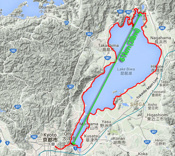
230km (143 miles) by bicycle
In the upper-rightish is the city of Nagahama, and that's about where the first post ended, so that's where this one picks up. We're moving around the lake in a counter-clockwise direction, so we're still not half way.
For a while north of Nagahama there's no road along the shore, so we have to head inland a bit...
 - 107 km (66.6 miles) taken while cycling at 21 kph (13 mph) -- Nagahama, Shiga, Japan -- Copyright 2015 Jeffrey Friedl, https://regex.info/blog/")
Panasonic LX100 at an effective 25mm — 1/1000 sec, f/5.6, ISO 200 — map & image data — nearby photos
Amber Waves of Grain
11:44 AM (+6h 17m) - 107 km (66.6 miles)
taken while cycling at 21 kph (13 mph)
 - 107 km (66.7 miles) taken while cycling at 20 kph (13 mph) -- Nagahama, Shiga, Japan -- Copyright 2015 Jeffrey Friedl, https://regex.info/blog/")
Panasonic LX100 at an effective 52mm — 1/1000 sec, f/5.6, ISO 200 — map & image data — nearby photos
11:44 AM (+6h 17m) - 107 km (66.7 miles)
taken while cycling at 20 kph (13 mph)
 - 107 km (66.7 miles) taken while cycling at 20 kph (12 mph) -- Nagahama, Shiga, Japan -- Copyright 2015 Jeffrey Friedl, https://regex.info/blog/")
Panasonic LX100 at an effective 24mm — 1/1600 sec, f/5.6, ISO 200 — map & image data — nearby photos
11:44 AM (+6h 18m) - 107 km (66.7 miles)
taken while cycling at 20 kph (12 mph)
 - 109 km (67.6 miles) taken while cycling at 22 kph (14 mph) -- Nagahama, Shiga, Japan -- Copyright 2015 Jeffrey Friedl, https://regex.info/blog/")
Panasonic LX100 at an effective 24mm — 1/800 sec, f/5.6, ISO 200 — map & image data — nearby photos
Stardestroyer
11:48 AM (+6h 21m) - 109 km (67.6 miles)
taken while cycling at 22 kph (14 mph)
There wasn't much traffic this far north in the boonies, but at one point a huge crane slowly passed us, making me feel like Princess Leia consular vessel being slowly overtaken and consumed by Darth Vader's Imperial Stardestroyer.
At about our half-way point, the main road goes through a long modern tunnel under some mountains. We'd rather go over the mountains, so we got onto the old original road and climbed the 50 vertical meters to an old tunnel...
 - 113 km (70.5 miles) -- Nagahama, Shiga, Japan -- Copyright 2015 Jeffrey Friedl, https://regex.info/blog/")
Panasonic LX100 at an effective 24mm — 1/60 sec, f/9, ISO 1000 — map & image data — nearby photos
12:03 PM (+6h 36m) - 113 km (70.5 miles)
The name, written above the entrance (backwards) is 「賤ヶ嶽隧道」, using the old word (suido) that's since been replaced by the Japanification of the English word “tunnel”. According to a plaque just inside the entrance, it took a bit more than a year of digging to break through the 1,260 shaku of length (382m / 418yd), and another two and a half years to actually finish the tunnel in 1927 at a cost of 279,642 yen. I don't know what the exchange rate was 88 years ago, but today that's about $2,250.

Inside the tunnel it was pitch black except for a splash of light in the center. Even in the day where you can easily see both openings, I wouldn't want to do it without a light, for fear of monsters and creepy things. Ugh.
But a slow shutter can see in the dark, so after I got home I got to actually see what the inside of the tunnel looked like:
 - 114 km (70.6 miles) taken while cycling at 11 kph (7 mph) -- Nagahama, Shiga, Japan -- Copyright 2015 Jeffrey Friedl, https://regex.info/blog/")
Panasonic LX100 at an effective 24mm — 1/8 sec, f/1.7, ISO 1600 — map & image data — nearby photos
Better Off Not Knowing
12:07 PM (+6h 40m) - 114 km (70.6 miles)
taken while cycling at 11 kph (7 mph)
Through to the other side, we were treated to a nice view of the lake....
 - 114 km (70.8 miles) -- Nagahama, Shiga, Japan -- Copyright 2015 Jeffrey Friedl, https://regex.info/blog/")
Panasonic LX100 at an effective 24mm — 1/1250 sec, f/3.5, ISO 200 — map & image data — nearby photos
60m Above Lake Biwa
12:09 PM (+6h 43m) - 114 km (70.8 miles)
This is pretty much at the exact spot where the green arrow in the map above touches at the top.
 - 115 km (71.1 miles) -- Nagahama, Shiga, Japan -- Copyright 2015 Jeffrey Friedl, https://regex.info/blog/")
Panasonic LX100 at an effective 65mm — 1/200 sec, f/7.1, ISO 200 — map & image data — nearby photos
Heading Back Down
12:16 PM (+6h 49m) - 115 km (71.1 miles)
The most direct path around the lake cuts off a peninsula of mountains that pierces the lake at its top, but of course we wanted to hug the lake as much as possible, and climb the mountains as much as possible...
 - 120 km (74.4 miles) taken while cycling at 19 kph (12 mph) -- Nagahama, Shiga, Japan -- Copyright 2015 Jeffrey Friedl, https://regex.info/blog/")
Panasonic LX100 at an effective 24mm — 1/400 sec, f/5.6, ISO 200 — map & image data — nearby photos
Heading Into the Mountains
12:40 PM (+7h 14m) - 120 km (74.4 miles)
taken while cycling at 19 kph (12 mph)
Half an hour of hard climbing later...
 - 126 km (78.0 miles) -- Nagahama, Shiga, Japan -- Copyright 2015 Jeffrey Friedl, https://regex.info/blog/")
Panasonic LX100 at an effective 28mm — 1/250 sec, f/10, ISO 200 — map & image data — nearby photos
View Of Lake Biwa
from 280m above the surface
1:13 PM (+7h 46m) - 126 km (78.0 miles)
 - 126 km (78.0 miles) -- Nagahama, Shiga, Japan -- Copyright 2015 Jeffrey Friedl, https://regex.info/blog/")
Panasonic LX100 at an effective 54mm — 1/100 sec, f/10, ISO 640 — map & image data — nearby photos
Well-Earned Rest
1:15 PM (+7h 48m) - 126 km (78.0 miles)
 - 130 km (80.6 miles) -- Nagahama, Shiga, Japan -- Copyright 2015 Jeffrey Friedl, https://regex.info/blog/")
Panasonic LX100 at an effective 50mm — 1/160 sec, f/6.3, ISO 200 — map & image data — nearby photos
Another Pause Lower Down
240m above
1:36 PM (+8h 9m) - 130 km (80.6 miles)
 - 131 km (81.4 miles) -- Nagahama, Shiga, Japan -- Copyright 2015 Jeffrey Friedl, https://regex.info/blog/")
Panasonic LX100 at an effective 32mm — 1/250 sec, f/6.3, ISO 200 — map & image data — nearby photos
Plummeting Down
1:43 PM (+8h 17m) - 131 km (81.4 miles)
I went ahead and tried to set up for a panning “action” shot of Gorm flying by, hoping I'd get everything blurry except him....
 - 134 km (83.0 miles) -- Nagahama, Shiga, Japan -- Copyright 2015 Jeffrey Friedl, https://regex.info/blog/")
Panasonic LX100 at an effective 24mm — 1/60 sec, f/6.3, ISO 500 — map & image data — nearby photos
1:47 PM (+8h 21m) - 134 km (83.0 miles)
He's sort of blurry too, but I'll claim partial success.
Once we alighted from the mountain, we had a pretty simple/flat 60-or-so kilometers (~40mi) shot down along the shore to complete our loop.
 - 147 km (91.4 miles) taken while cycling at 25 kph (15 mph) -- Takashima, Shiga, Japan -- Copyright 2015 Jeffrey Friedl, https://regex.info/blog/")
Panasonic LX100 at an effective 35mm — 1/160 sec, f/6.3, ISO 200 — map & image data — nearby photos
Annoying Japanese Habit
2:32 PM (+9h 6m) - 147 km (91.4 miles)
taken while cycling at 25 kph (15 mph)
Japanese people seem to love to smolder plant clippings, spreading smoke everywhere. One farmer deciding to get rid of some cuttings can ruin a whole town's futons and other fabrics hug out to dry. It boggles my mind, but people just seem to think it's natural.
Two hours after descending the mountain, we catch our first sight of the gate for the Shirohige Shrine, which we'd visited from the other (closer to Kyoto) direction a month prior on my first ride that exceeded 100km. That was the subject of “Pleasant 105km Bike Ride Takashima’s Shirohige Shrine”...
 3:51 PM (+10h 24m) - 170 km (105.6 miles) taken while cycling at 15 kph (9 mph) -- Takashima, Shiga, Japan -- Copyright 2015 Jeffrey Friedl, https://regex.info/blog/")
Panasonic LX100 at an effective 24mm — 1/400 sec, f/5.6, ISO 200 — map & image data — nearby photos
First Sight of the Shrine Gate
(I think ... it'd be pretty tiny in this photo)
3:51 PM (+10h 24m) - 170 km (105.6 miles)
taken while cycling at 15 kph (9 mph)
20 minutes and 8km later, we're much closer...
 - 178 km (110.8 miles) taken while cycling at 26 kph (16 mph) -- Takashima, Shiga, Japan -- Copyright 2015 Jeffrey Friedl, https://regex.info/blog/")
Panasonic LX100 at an effective 25mm — 1/320 sec, f/6.3, ISO 200 — map & image data — nearby photos
4:12 PM (+10h 45m) - 178 km (110.8 miles)
taken while cycling at 26 kph (16 mph)
 - 179 km (111.1 miles) Shirahige Shrine (白鬚神社) -- Shirahige Shrine (白鬚神社) -- Takashima, Shiga, Japan -- Copyright 2015 Jeffrey Friedl, https://regex.info/blog/")
Panasonic LX100 at an effective 28mm — 1/1000 sec, f/3.5, ISO 200 — map & image data — nearby photos
Arrival
4:15 PM (+10h 48m) - 179 km (111.1 miles)
Shirahige Shrine (白鬚神社)
This was the first thing around the whole lake that was familiar, and at least to me signaled the end of the challenge. Now we just had to get home, but that was still a few hours off.
 - 198 km (123.0 miles) taken while cycling at 29 kph (18 mph) -- Otsu, Shiga, Japan -- Copyright 2015 Jeffrey Friedl, https://regex.info/blog/")
Panasonic LX100 at an effective 29mm — 1/125 sec, f/5.6, ISO 200 — map & image data — nearby photos
Labor-Intensive Farming
5:11 PM (+11h 44m) - 198 km (123.0 miles)
taken while cycling at 29 kph (18 mph)
Finally at 6:00 in the evening we overlapped our morning path, completing our trip around the lake.
 - 216 km (134.0 miles) -- Otsu, Shiga, Japan -- Copyright 2015 Jeffrey Friedl, https://regex.info/blog/")
Panasonic LX100 at an effective 24mm — 1/1000 sec, f/2.2, ISO 200 — map & image data — nearby photos
Objective Achieved
6:00 PM (+12h 33m) - 216 km (134.0 miles)
This was taken near the site of this photo from the morning, almost 12 hours earlier.

Now that we had completed the loop, we had to pop back over to Kyoto, which first involved a 105m climb over a small mountain...
 - 219 km (135.8 miles) -- Otsu, Shiga, Japan -- Copyright 2015 Jeffrey Friedl, https://regex.info/blog/")
Panasonic LX100 at an effective 75mm — 1/125 sec, f/2.8, ISO 500 — map & image data — nearby photos
Cresting the Pass
6:35 PM (+13h 9m) - 219 km (135.8 miles)
I'm happy with the amount of blur I get in the wheels and spokes at this shutter speed.
Kumiko was happy because she could do the hill (and indeed the entire day) in her clip-in shoes. It gave her a lot of confidence with them.
Gorm was happy because he got to have a nice rest while waiting for us; he flew up that mountain.
Part of the descent down the other side is really steep, but the effect is enhanced by being right next to a highway....
 - 219 km (136.2 miles) taken while cycling at 20 kph (12 mph) -- Otsu, Shiga, Japan -- Copyright 2015 Jeffrey Friedl, https://regex.info/blog/")
Panasonic LX100 at an effective 75mm — 1/160 sec, f/2.8, ISO 200 — map & image data — nearby photos
Landing Approach
6:37 PM (+13h 10m) - 219 km (136.2 miles)
taken while cycling at 20 kph (12 mph)
After that, just before arriving home, there was one final 50m hill. The other side of the hill was the first little climb of the day, and I was happy to find out when looking at the data later that I made a personal-best fast time on both the climb leaving Kyoto that morning, and the climb returning home that evening. Both little climbs were ones that I had given my all on before, so it was all the more gratifying to make PRs on them as bookmarks to my longest ride (in time and distance).
I returned home after almost 14 hours on the bike, and felt great. I guess distance doesn't tire me out, just vertical climb, and this one had only about 1,500m (4,800 ft). The rides I've done since are shorter, but usually have much more mountain climbing.