The Kuala Lumpur airport (KLIA) seems as modern as any I've ever seen. Just as when flying into the international wing of Chicago or LAX, you must go down a long hallway after exiting the gate. Unlike Chicago and LAX, yesterday we had long “peoplemovers” to do the walking for us. They dumped us into what turned out to be a remote terminal hub, a beautifully architected multi-story open atrium area of shops (yes, including a Starbucks) overflowing with green. The elevator enclosures were clear tubes of glass that had people flowing on all sides -- really, quite impressive.
We then road the automated minitram to the main building. Following Fumie's mom (who's done this several times), exiting the tram she headed right while the massive flow of humanity headed left. It turns out that KLIA has separate immigration controls for travelers with connections, so after descending a level, we were greeted with a mini immigration section with a line all of one person deep. It was fantastic.
As an aside, I'll note that the last time I entered the US (last summer, at Chicago, I think), while waiting as next in line for immigration, the unprepared family at the head of the line next to us was getting treated so rudely by the immigration officer that I cringed and was embarrassed to be American. His “soul spirit” sister must have been working as the Malaysian immigration officer for the line next to us, as she was exceptionally rude to the unprepared family next to us. I guess it's the same everywhere. )-:
Anyway, after all of three minutes, we were through and into the domestic terminal where we were met by Fumie's dad, conveniently returning from a business trip. We made the short flight to Penang to discover that Penang's small regional airport was modern, bright, and clean, and like any modern airport full of shops hawking high-priced booze and purses. Oddly, though, and I should stress that this was the only hint of “third-worldness” I've seen so far, I did not notice a Starbucks.
Fumie's dad had a car, but it wouldn't fit all six of us, so he arranged a taxi to take us to our hotel, the “Krystal Suites”. It was just after sunset and the drive was quite pleasant -- lots of green and modern-looking shops.
The hotel room, really a two-bedroom suite with a 40-foot-long living room, is larger than our previous whole apartment. The bathroom is a bit suspect, and the floor is randomly lumpy, but otherwise it's fine. The air conditioners (4) work, which at this point seems to be the most important thing (since it's in the 90s and muggy every day).
After dumping our luggage, the others joined us and we took a walk to a restaurant. I had to laugh when they walked into a Japanese restaurant(!) But it was 8pm (9pm Japan time) and Anthony was very tired and wanted milk, which the restaurant didn't have. So Fumie's dad and I walked a bit further to a 7-11 convenience store. (It turns out that this 7-11 is just a bit further from our hotel than the 7-11 near our place in Kyoto is far from our place). We got a bunch of bottled water and some milk. It filled a bag, and came to 8-something Ringgit -- about US$2.30.
The street was full of well-maintained cars, and not full of garbage. It seems to be a nice area.
Anyway, Anthony was so tired that I just took him back to the hotel, gave him his milk, and put him down.
GPS
One thing that struck me during this trip is how easy it is for GPS reception to be totally obscured. My GPS receiver got absolutely no reception unless it was pressed up against the window of the plane. Moving it, say, to my lap, and it got nothing. I guess the GPS designers had cruise missiles and other “have a clear view of the sky” items in mind.
Also, my GPS unit (Garmin GPSmap 60CS) has two ways to determine the altitude: a barometer and GPS. Inside a pressure-controled plane, the barometer is fairly useless, but I couldn't find a way to have it use the GPS for altitude (other than the one-time “Altidude via GPS” on the Satellite-Acquisition page's menu). Thus, while flying at 40,000 feet, it mostly said we were at 2,000 some meters. Fairly worthless )-:
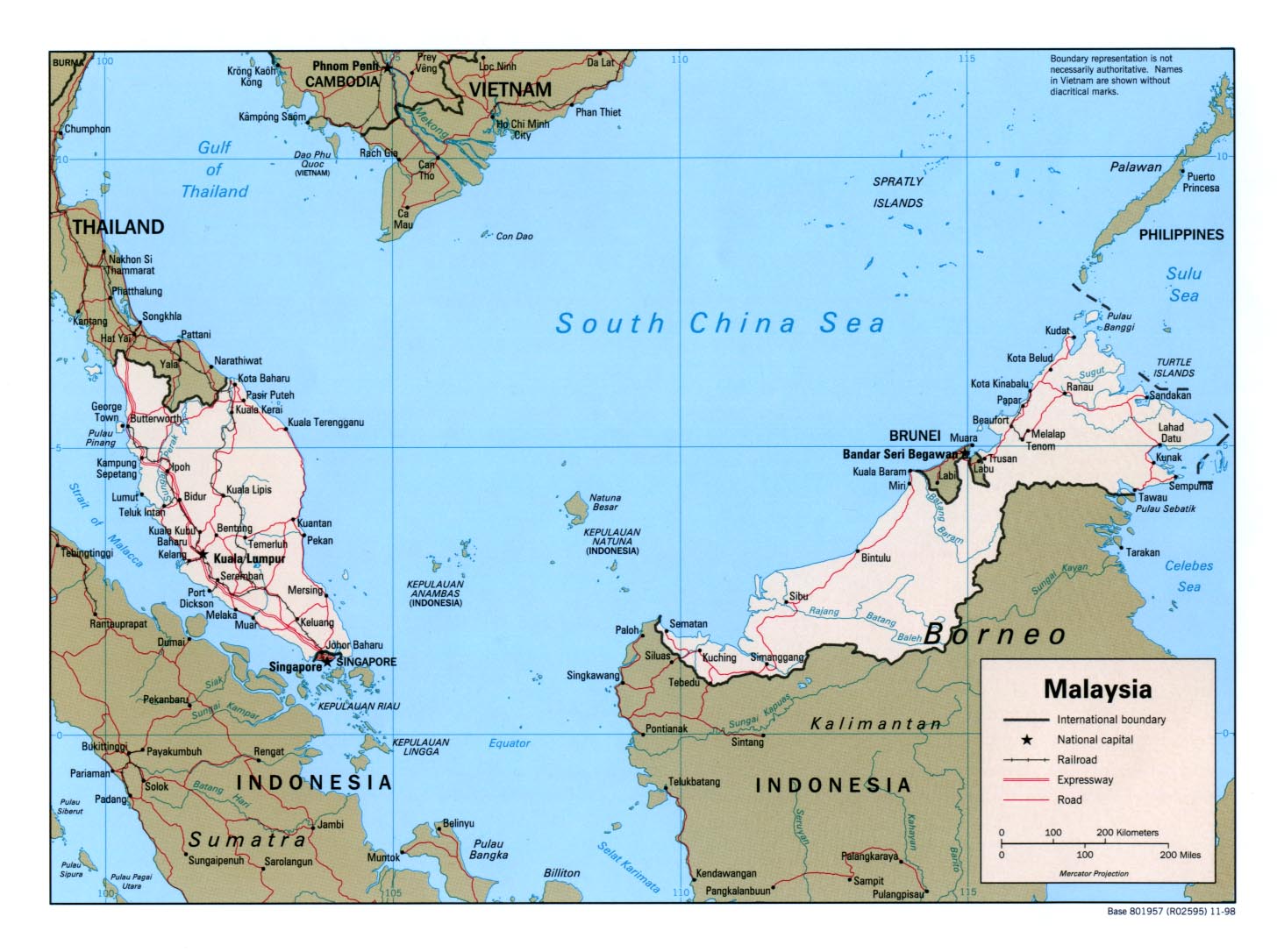
I'm still sluggish from my cold, but nevertheless, tomorrow we're all leaving for George Town, on Penang Island in Malaysia, to visit Fumie's Dad who is there on a long-term work assignment. (You can see George Town on the far left of this map)
Five of us (Fumie and Anthony and I, Fumie's mom, and Fumie's brother Shogo) take a shuttle to Kansai International, then fly to Kuala Lumpur (about 7 hours) and on to Penang (another hour). Shogo is staying only three days; the rest of us stay ten days.
It's at about 5 degrees north latitude and hot and humid and forecast to rain every single day we're there, although apparently the rain comes and goes -- it's not a 24/7 incessant drizzle like Japan's rainy season.
We're flying Malaysia Airlines, which will be the first time in almost 10 years for me to fly a new airline. This got me thinking about the various airlines I've flown -- here are the ones I can remember:
|
All Nippon Airways
American Airlines America West (added July 2006) Asiana Bangkok Air Cathay Pacific Airways Continental Airlines Delta Airlines Indian Air Japan Airlines Korean Air Malaysia Air (added March 2006) Midwest Airlines Northwest Airlines Pam-Am People Express Reno Air Singapore Air Southwest Thai Air United Airlines United Express USAir |
I have a vague memory of flying Lufthansa as well, but can't pin it down. There are probably others that I can't remember at all.
By far the most miles are on United, probably followed by Korean Air. The least are probably the one short puddle-jumper flight on Bangkok Air.
I don't know whether it was flu or a common cold or SARS or what, but whatever it was lay waste to me and my family this week. In my case, Thursday was the first day since Sunday that my temperature didn't rise above 40C (104F), and today (Saturday) is the first day that I have no fever at all (well, so far).
It started a week ago (Saturday) with Anthony having a mild cough. On Sunday he had a temperature up to 40C, and Fumie was feeling bad too. It hit me on Monday with a force I've never been hit before. It's been the worst cold I can ever remember (and I can remember a lot, considering that this is my fourth cold this year).
Whatever bug is responsible is very persistent. With all of us, the cold seems to “break” (we wake up in a cold sweat and soaked clothes) and we think we're over the worst of it, but it comes back with gusto the next day. For me that was three days in a row, with Thursday finally having just a “normal” mild cold all day. Today (Saturday) is the first day for me without any fever, although I still have very little energy and am so tired my eyes feel like they're falling out (yet for some reason just can not sleep). Fumie had it bad even longer.
Thank God for Fumie's mom, who lives next to us -- she was able to look after Anthony much of the time Fumie and I were incoherent. I'm also thankful for “Dora the Explorer”, which we used to babysit Anthony during much of the rest of the time. He's seen more video this week than all the previous days of his life combined. And Anthony's cold was relatively mild and short-lived, likely thanks to Fumie having gotten him a flu shot a month ago.
At least it happened this week and not next; on Monday we're all heading to Malaysia for two weeks, to visit Fumie's dad, who's there on a long-term work assignment.
There are a lot of wires strung across the sky in Japan. A lot of wires.
Here's a picture of the utility pole closest to our place:

Utility Pole Closest to Our Place (West Side)
As you might imagine, it's quite pleasant to see every day. (NOT!)
Looking straight up from where I took the first shot, you can see in the photo below the utility pole closest to the other side of the entrance. All the wires strung between the two go right across the face of the building.

Utility Pole Closest to Our Place (East Side)
Double yuck.
Frankly, since these poles and masses of wires are pretty much ubiquitous, you quickly and naturally learn to “tune them out” in everyday life. However, they are a huge eyesore when they show up in photographs. Here's a picture I took on the day we took position of our place, from the balcony:


I think it looks quite nice, but unfortunately, it's not quite reality. Rather, it's the “after” of some Photoshop “tuning out” -- put your mouse over here to see the original superimposed above. You'll see a lot of wires. )-:
I'm getting my wish!
We just found out that our street (Nioomon-dori) will undergo nine months of horrendous construction, the aim of which is to bury all the wires and remove all the poles. Our section of the street will be under construction from the beginning of April until the end of October.
It will certainly make for a traffic nightmare. But I can't wait for the result; it will be so beautiful.
UPDATE: Sadly, it turns out that they didn't remove the utility poles or wires. They widened the sidewalk and made it very nice, and paved the street, but they said that the wires and poles will remain for a few more years )-:
Since I'm getting more interested in photography and understanding cameras and techniques, I find myself wanting to know the details under which a photo was taken. Modern digital cameras encode a lot of such data — shutter speed, lens focal length, etc. — into the image file, generally called “Exif Data” (“Exif” stands for “Exchangeable Image File Format” and as an acronym would normally be written as “EXIF”, but the standard creators explicitly say that it should be written “Exif”, which is nice.).
As of Dec 2016 this tool has moved to http://exif.regex.info.
So, I wrote a little online Exif viewer to view whatever data might be encoded. Here's a screenshot using the viewer on a picture from a recent post:

|
That's just the summary — you can see the full data using the tool itself.
The amount of data encoded in the image is quite variable. Many times there's just about nothing, as the data is stripped somewhere along the way. Here's a version of the previous picture with most data missing. It's missing because it's a smaller version that's meant for web display, and for such use the data just makes the file bigger and slower to download.
Geoencoded photos get links in the summary area to Google Maps and the like, and below that is an embedded Google Maps pane. With either, you can switch between Satellite and Map, and zoom, etc..
My Tech-Related Photography Posts
- My Lightroom-to-iPad Workflow
- Lightroom Goodies (lots of plugins)
- Digital Image Color Spaces
- Online Exif (Image Data) Viewer
- Jeffrey's Autofocus Test Chart
- Photoshop Calendar-Template-Building Script
- How to Prepare Photos for an iPad
- A Qualitative Analysis of NEF Compression
- Tripod Stability Tests
more...
You can also check images on your local hard drive — images directly from a camera generally have the most information. Give it a try!
If you're using Firefox or Safari, you have the added benefit that you can install an Exif-viewer button on your button-bar toolbar. Once you've done that, later, when you're viewing a page with an image you want to check out, just click the button and you'll be whisked to a new tab showing the image's data. I find this really useful. It doesn't work in IE, though, sorry.
I use the viewer a lot on images I see in the Digital Photography Review Samples and Galleries forum. Lots of nice pictures in there. Many have their Exif data stripped, but many do not.
Finally, I should note that my viewer makes use of Phil Harvey's most excellent Image::ExifTool library. Thanks Phil!