
Just a Bit of Rain
Supertyphoon “Jebi” (Typhoon #21) passes near Kyoto
(My area of Kyoto is the black dot to the lower right of center)

iPhone 7 Plus— 1/120 sec, f/2.2, ISO 32 — map & image data — nearby photos
Ready to Head Out
in the calm at 10am, four hours before the radar screenshot above
Having grown up in Ohio with its summer thunderstorms, I like “dynamic” weather. I enjoy riding my bike in the rain, even if the rain is hard and the wind is blustery, so long as it's warm. If I know it's going to rain, I know I'll get wet and so I'll prepare accordingly, and I'll embrace the rain instead of try to avoid it.
This lack of fear of getting wet is apparently sufficiently rare that it makes me appear to be “crazy” in the eyes of many. Whatever. I enjoy it.
A “supertyphoon” was forecast to pass near Kyoto at about 2pm, so I thought I'd go out for a ride beforehand, to enjoy some of that “dynamic” weather before it got too bad. I set out at about 10am intending to do a loop that normally takes me about two hours. There was no rain yet, but the wind was a bit blustery.

iPhone 7 Plus— 1/30 sec, f/1.8, ISO 100 — map & image data — nearby photos
Denied!
the typhoon claims its first victim: my certain KOM on a favorite segment
Half an hour into the ride, I came to “Zenkoji Flyby Northbound”, a short punchy segment, and I hit it hard. On my previous visit last week, I set a new personal record and came within 8 seconds of the KOM (“King of the Mountain”, the best-recorded time), despite having to go somewhat gingerly because the road was wet in some areas. Today the road was dry and I was feeling really good, putting out more than 1,000 watts at the start, until I came around a corner near the end to find the road was closed.
Someone saw me standing there in front of the gate, and told me "oh, it's fine for you to go... we just put that there because the typhoon is coming." Great. I was bummed, because I'd been I was 8 seconds ahead of the current KOM's pace, so I certainly would have gotten it. I asked whether I could move the gates aside temporarily so I could give it a try, and he said something along the lines of "I'd like to say yes, but the city asked me to put the gates there, so I can't". Oh well, I'll try again after the ground drys off.
At least it afforded me the chance to take in the view from the area, which was nice:

iPhone 7 Plus— 1/1800 sec, f/1.8, ISO 20 — map & image data — nearby photos
Calm Before the Storm
Otsu City, Shiga Prefecture, Japan
 closed in preparation for the typhoon -- 3 -- Otsu, Shiga, Japan -- Copyright 2018 Jeffrey Friedl, https://regex.info/blog/")
iPhone 7 Plus— 1/120 sec, f/1.8, ISO 25 — map & image data — nearby photos
Closed Today
Mii-dera Temple (三井寺) closed in preparation for the typhoon
It wasn't until an hour an a half into the ride, at 11:20am, that it started to rain.... just a mild, spritzy-drizzle. The wind continued to have stronger gusts at times, but it was still entirely fun and not even close to being any kind of danger. So, I decided that once I got back to Kyoto, instead of heading home I'd pop into the mountains a bit, and I invited a few friends to join.

I returned to Kyoto around noon, and met up with the one friend who could join, Maithilee, and we headed off to do the western half of Kyoto's Heart Loop, starting with the climb up to Kyomi Pass.
 -- Kyoto, Japan -- Copyright 2018 Jeffrey Friedl, https://regex.info/blog/")
iPhone 7 Plus— 1/120 sec, f/1.8, ISO 32 — map & image data — nearby photos
Starting to Get Soaked
but the rain still wasn't very hard yet
(yes, she should have a helmet; she has one, couldn't find it, and decided to come anyway)

iPhone 7 Plus— 1/60 sec, f/1.8, ISO 32 — map & image data — nearby photos
Some Small Debris Accumulating
Here's a short video:
(the video makes it seem a lot worse than it was)
At this point the wind was definitely “dynamic”, but not dangerous. Still, I wouldn't want to stay out if it got much worse.

iPhone 7 Plus— 1/200 sec, f/1.8, ISO 20 — map & image data — nearby photos
Bent Trees
I'm starting to feel that it's getting worse
It started to get stronger as we neared the top, and I thought we should abort the ride and head back soon.
Let me make it clear that I'm intimately familiar with the damage a typhoon can do. As seen in “2017’s Typhoon #21 (Lan) was Quite the Doozy for Kyoto”, trees and utility poles were snapped like toothpicks. I want no part of that, and we were no where near that point. I wouldn't be near that point if it were near that point.
Still, the debris were also getting bigger, and especially with her not having a helmet, I worried about a branch or something bonking her on the head, so head back soon we would.

iPhone 7 Plus— 1/35 sec, f/1.8, ISO 32 — map & image data — nearby photos
Relatively Calm at the Top
but time to get back to town
Back in town it was much calmer.
On the way out of town, we'd noticed that a friend had left her windows open, so on the way back down, with the rain now getting stronger, we stopped in to close them for her.
We also took the opportunity to try a short segment nearby, that I've been wanting to get the KOM on. In the past I'd come close, but had trouble with bad GPS tracking (my pause after having completed the segment would somehow get added to my effort time), or with having to abort the attempt because of people or cars or something. Today I wasn't sure whether I should even bother, because the wind felt like it was blowing all directions at the same time, but I gave it a shot and did well and got my KOM. I'll want to go back on a less-blustery day to see just how much of that was from the weather and how much was from me.
Maithilee got the QOM (“Queen of the Mountain”) on it by virtue of her being the first female to do it. 🙂
By this point the wind was still much more calm than in the mountains, but the rain had started to pick up.
I just love riding in this

iPhone 7 Plus— 1/60 sec, f/2.8, ISO 400 — map & image data — nearby photos
Perhaps Not So Fun For Her
she was getting soaked to the bone just like we were,
but unlike us, she didn't do it on purpose
though the rain is now strong

We knew the main storm still hadn't arrived, but would, so we were winding down our ride. As I escorted her back to her place, stopped at a traffic light we noticed that the wind really had picked up, and was racing through the small alleyways...

iPhone 7 Plus— 1/60 sec, f/2.8, ISO 200 — map & image data — nearby photos
River with Waves
the waves were against the flow of the river
Just before we got to her place, a gust of wind came that was unlike anything I'd experienced since my rides up Mt. Fuji a couple of months ago. It was so strong, instinct brought us both to a halt and off our bikes, to steady ourselves. This was the real storm arriving.
We happened to have a good view of a river, which was flowing away from us, but it looked to be flowing toward us:
It was time to get inside, and we did.
The storm raged outside as I fought with Apple's “Air Drop” feature, trying to send the photos and videos I'd taken to her phone. It normally works so smoothly, but for some reason just didn't want to work well this time. I eventually gave up and headed back out. I hadn't been there long, but the worst of the storm had clearly passed.
I felt completely safe riding home, except for the occasional bit of flying sheet metal. I kept eagle eyes out for that, and otherwise enjoyed myself immensely.

iPhone 7 Plus— 1/30 sec, f/1.8, ISO 20 — map & image data — nearby photos
Flipped-Over Bus Signs
their base looked to be so heavy that I didn't even try to put them back


iPhone 7 Plus— 1/30 sec, f/1.8, ISO 40 — map & image data — nearby photos
The Kind of Sheet Metal I Was Worried About
as the metal shutters flapped in the gusts

iPhone 7 Plus— 1/60 sec, f/2.8, ISO 64 — map & image data — nearby photos
Behind the Heian Shrine
Its trees still looked full, but so does the street
 -- Kyoto, Japan -- Copyright 2018 Jeffrey Friedl, https://regex.info/blog/")
iPhone 7 Plus— 1/160 sec, f/1.8, ISO 20 — map & image data — nearby photos
In Front of the Heian Shrine
a tree fell across the road

iPhone 7 Plus— 1/120 sec, f/1.8, ISO 20 — map & image data — nearby photos
Proper Preparation
That crane has been in use for a year, now tucked away safely for the storm


iPhone 7 Plus— 1/120 sec, f/1.8, ISO 32 — map & image data — nearby photos
Kamo River Seems Fine
no problems, unlike previous times like this and this
 -- Kyoto, Japan -- Copyright 2018 Jeffrey Friedl, https://regex.info/blog/")
The wild weather was winding down quickly, so I called it a day and headed home.
Here's the ride on Strava:
I'd seen some big damage, as shown above, and a lot of small things like fallen roof tiles and people's stuff being blown around. I knew it would take some cleanup. But nothing I'd experienced out on the ride prepared me for what I'd see online when I got back, mostly from Osaka. It was horrifying:
- wind blows truck/car off a bridge
- a roof attacks the vidographer
- a house is upended and blown away
- a tanker knocks a bridge off its base, stranding Kansai International Airport
There are also now plenty of compilation videos showing more.
There's also this video of Kyoto Station, often accompanied by text claiming that the roof was falling in. My guess is that the big square metal thing we see fall was actually blown from somewhere else, and simply came crashing through one of the glass panes.
In any case, all these Osaka videos were quite a shock. Kyoto didn't get hit nearly so hard, thankfully.
The next day was calm and pleasant, and I took a ride to check out the mountains where I had been as the storm approached. That's a story for the next post, but let's just say that I'm very, very glad that I turned around and came back when I did.

iPhone 7 Plus — 1/40 sec, f/1.8, ISO 25 — map & image data — nearby photos
Starting in the Ocean
rear wheel in the Sea of Japan
city of Toyama, Toyama Prefecture, Japan
I recently did a bicycle ride that I'd been planning for months: to do Japan's biggest road climb, a single climb going from sea level to Japan's highest paved road at Mt. Norikura, at an elevation of 2,717m (8,914'). As far as I know, it's the biggest possible elevation gain in a single paved-road climb in Japan, and as far as I know, it's never been done, or even known of, until now.
I've ridden that “highest paved road in Japan” road before, as blogged about here, but this time I would start 110km (68mi) away at the ocean (elevation: 0), in the city of Toyama.
I'd spent months researching the most direct route from the ocean, updating road data (as described in “Updating Maps for Cycling, Including Japan’s Pseudo One-Way Roads”), refining my elevation database, and scoping out places to get food and drink along the way.
Here's the route that I came up with:
... and here's the elevation profile:
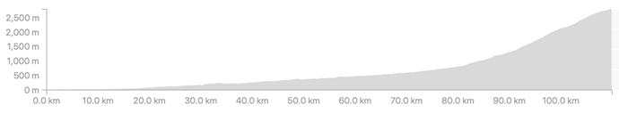
It's almost completely flat at the start, rising ever-so-gently from the ocean towards the mountains. It's one solid climb all the way from pretty much anywhere you start in Toyama; I found a boat launch that's paved into the ocean, so that seems to be a great place to start.

I'd gotten a hotel in Toyama, and was out the door by 5am to make the 20-minute ride up to the climb's starting spot in the ocean. I'd come the previous afternoon, after checking into the hotel, to make sure that it still existed (I'd done all my research with Google Maps and Google Earth).

iPhone 7 Plus — 1/30 sec, f/2.2, ISO 64 — map & image data — nearby photos
Ready To Roll
selfie just before starting out, with the rear tire in the ocean
I picked a simple path through the city, so as to make an easy-to-follow route in case others might want to do it.
I say it's “one unbroken climb”, but that's in the big-picture sense, and doesn't mean that every step forward actually goes up. (If that were the case, traversing a speed bump would break a climb into two.) There are times over the 110km that the roads dips down slightly, such as a short mild descent to meet a bridge that crosses a river, or to dip under train tracks:

For all practical purposes, though, it's one single climb, and so I was looking forward to have it under my belt.

The sun rose at 5:35, but didn't make an appearance until 6am. I thought it was lovely at the time, but it heralded a strong wind that materialized out of nowhere. I'd been feeling good until then, but then became consumed with worry that I'd have to contend with the wind for the next five hours, until I got to the steep stuff (for which a wind doesn't matter as much).
 away -- Toyama, Japan -- Copyright 2018 Jeffrey Friedl, https://regex.info/blog/")
iPhone 7 Plus — 1/120 sec, f/2.8, ISO 25 — map & image data — nearby photos
First Sight of the Goal
I think that's Mr. Norikura to the right of center, 65km (40 mi) away

iPhone 7 Plus — 1/125 sec, f/2.8, ISO 20 — map & image data — nearby photos
“Steep” Section Early On
The first 80km has only 800m of climb, so it averages a very mild 1%, though there are a few short sections at 5%. There's even one very short bit that goes down at 5%, but it's so short that it has no material impact on the overall climb.

iPhone 7 Plus — 1/60 sec, f/2.8, ISO 1250 — map & image data — nearby photos
Lots of Avalanche-Protection Half Tunnels
I felt good, other than the headwind and a slight bloating feeling. I was worried that I'd not have a lot of chances to refill on water during the ride into the mountains, so I was drinking a lot and refilling whenever I had the chance. I was also eating copious amounts, in addition to the big breakfast I'd had at the hotel, so as to avoid The Bonk (running out of energy) on the long ride. In this I was successful.
 -- Hida, Gifu, Japan -- Copyright 2018 Jeffrey Friedl, https://regex.info/blog/")
iPhone 7 Plus — 1/120 sec, f/2.8, ISO 20 — map & image data — nearby photos
Much Cooler than I Expected
22°C (68°F)

iPhone 7 Plus — 1/350 sec, f/2.8, ISO 20 — map & image data — nearby photos
Horrible Photo of a Gorgeous Scene
I wish I had my real camera

iPhone 7 Plus — 1/60 sec, f/2.8, ISO 1250 — map & image data — nearby photos
One of Several
long tunnels


iPhone 7 Plus — 1/610 sec, f/1.8, ISO 20 — map & image data — nearby photos
Free, Drinkable Water
I'm not sure why it was presented this way, but I was thankful for the water

Despite what one might think at first, that sign doesn't mean “12% grade for the next 6km”, but instead it means that there are sections that are up to 12% steepness at points during the next 6km. The average for the 6km is actually just 5%, so it's not that bad.

iPhone 7 Plus — 1/280 sec, f/2.8, ISO 20 — map & image data — nearby photos
Norikura Disappearing into the Mist
I thought it was pretty at the time. Little did I know...

iPhone 7 Plus — 1/240 sec, f/1.8, ISO 20 — map & image data — nearby photos
First Mention of “Norikura”
100km into my ride

iPhone 7 Plus — 1/250 sec, f/2.8, ISO 20 — map & image data — nearby photos
First Street Sign with “Norikura”

iPhone 7 Plus — 1/120 sec, f/2.8, ISO 20 — map & image data — nearby photos
Absolutely-Ridiculous Signage
I've written about the ridiculous way some Japanese road-restriction signs present themselves, such as in “No Motorcycles Allowed….. Sometimes… Sort of”, but the one above takes the cake.
Here's a literal translation of the various parts:
(Note that in Japanese traffic law, a bicycle
is a “vehicle” just like a car or truck or bus.)
May 15 through June 30
October 1 through October 31
6pm through the next day's 7am
July 1 through September 30
6pm through the next day's 3:30am
(busses, taxies, bicycles, special permission excepted)
May 15 through June 30
October 1 through October 31
7am through 6pm
July 1 through September 30
3:30am through 6pm
Norikura Skyline
What this is saying, in the most-convoluted way, is:
From July 1 through October 31, only buses, taxies, bicycles, and those with special permission are allowed, and only during the day (well, from 3:30 am in the middle of the summer).
The sign doesn't mention anything about other times of the year (fall, winter, and spring), but I know that the road is physically closed off with a gate, due to snow.
The takeaway from this is that normal passenger cars are completely prohibited at all times.
I don't understand why they need to present it in such a convoluted way. Everything is a restriction (including the “... excepted” part, which is a restriction on the restriction), which I suppose is fine, but why couldn't they say it simply?
I wonder how long it would take the average Japanese driver, when presented with these signs, to realize that they're telling him that he's not allowed to proceed?
Also odd is that the signs aren't about the road that they're on. For whatever reason, these signs were placed on the main road, but they talk about the road that turns off to the left. Very strange.
In any case, as a cyclist, I was allowed to take the road at that date and time, so I did. It was steep, but pretty.

iPhone 7 Plus — 1/120 sec, f/1.8, ISO 32 — map & image data — nearby photos
Deep Nature
very steep nature


That section of road was about 4km, and averaged 9.3%.
It brought me, finally, to the Norikura Skyline, the last 14km (8.5 mi) stretch to the top. Despite being only 13% of the distance, its 1,020m (3,350') of climb comprised more than a third of the entire trip's. It averages a 7.3% grade overall, but that belies the fact that not all sections are the same: the 2nd and 8th kilometers average 10%, and the kilometer after each of those averages 9%. On the other end of the scale, the 13th kilometer averages only 3.6%, bless its heart.
This final push to the top would be the most physically-demanding section, but having completed the long, mentally-demanding runup to here, with the goal in sight, I was feeling good.
That didn't last long.

iPhone 7 Plus — 1/160 sec, f/2.2, ISO 25 — map & image data — nearby photos
Denied
turned away because of “too much fog”
As I approached the guard/toll gate, a worker had come out and stood waiting to meet me with wrists crossed in an “X” sign, the universal sign in Japan for “no/closed/bad”. I knew immediately that my attempt at Japan's Biggest Climb was over, because I knew that in Japan when these kinds of decisions were made, they were completely non-negotiable.

iPhone 7 Plus — 1/1400 sec, f/1.8, ISO 20 — map & image data — nearby photos
List of Road-Closure Conditions
none of which were triggered, except for the vague “snow/ice/fog” at the bottom
The “too much fog” reason is just so stupid. I can certainly take responsibility for myself, and as for others, the road is always closed to normal traffic, so the only vehicles allowed are the occasional taxi or bus driven by professionals. (As you can see in the photo above, the toll for a large bus is 10,200 yen, about US$100!) I had bright flashing lights both front and back, and the fog, however thick it was, would have been only at the very top anyway. It was just stupid.
It seems that I should have checked The Skyline's home page to see the current status, I learned from the guard. As of this writing, the road is open to cyclists, as evidenced by the marked circle:
When I was turned away, it was an “⨉”, and had been so from the previous day.
Now I know.
Overall, I spent half an hour there, at first trying to talk my way in, and then in figuring out what I'd do going forward. The main guy I talked to (not the one in the photo above) was full of empathy and easy to talk to, so that made things better, but it was still so very disappointing. I turned around to return to the hotel.
I eventually headed down a different way than I'd come up, via a lovely descent. But after having ridden more than 100km up hill, any descent would have been lovely.
The road eventually flattened out, and in the flatter areas the headwind had returned. Since three hours had been cut from my trip by the Norikura Skyline guard, I had plenty of time and was in no rush, so I took it easy, as I had been all day.
50km (32mi) into my return, I had a momentary worry about another road closure:

iPhone 7 Plus — 1/1000 sec, f/1.8, ISO 20 — map & image data — nearby photos
“Road Closed”
“Route 360 toward such-and-such a Pass”
I'd had two routes worked out for my return, one that was easy and one that looked to be very, very hard. On the return I'd been toying with the idea to try the hard one, but on paper it seemed almost as hard as the Mt. Fuji climb I'd done two months prior, which was both mentally and physically very difficult for me, so I'd decided that I just wasn't up to trying it. But now with this huge “Road Closed” sign, I worried that I'd have to do it.
I came across some road workers and asked whether the easy road to Toyama was closed. “No idea”. A bit farther on, I came across some surveyors and asked the same, and was cheerily told that it was open and without hills all the way. That sounded good.

This road, which was bypassed by a modern tunnel, looked much more appealing in Google Street View photos from four years ago:
As it was, I had to pick my way between the overgrowth, and among many fallen rocks and branches, but it was still nice.
The next 25km (17mi) were mostly downhill, and I seemed to have a tailwind because at times my speed was more than I could otherwise explain. It was nice.

iPhone 7 Plus — 1/240 sec, f/2.8, ISO 20 — map & image data — nearby photos
Pretty View
but again, the iPhone photos just don't do it justice
 -- Toyama, Japan -- Copyright 2018 Jeffrey Friedl, https://regex.info/blog/")
iPhone 7 Plus — 1/32000 sec, f/1.8, ISO 25 — map & image data — nearby photos
Rice Fields at the Edge of the City
taken at 32 kph (20 mph)
I arrived back at the hotel 10 minutes shy of a 12-hour ride. I'd ridden 215km (134mi) and climbed only 2,177m (7,150'). If I'd had done the complete climb, and the harder return, the climb would have been about double, and my biggest ride in that respect. As it was, the amount of climb was nothing special (it's ranked #39 in my rides by climb). By distance, it's my #6-longest ride.
I brought my scale along to weigh myself before and after. During the ride I had 9,075ml of drink (2.4 gallons) which in itself weighs 9kg (20lb), and in addition ate in abundance, but I still lost 3.8kg (8.4lb) during the 12-hour ride. This did involve one bathroom break, but the bulk of the loss was 28 pounds worth of sweat. Wow.
Here's the ride at Strava:
And here's the Relive video of it:
Relive 'My Super Disappointing Ride of Crushing Disappointment / がっかりばかりのライド'
My hotel was a nice business-budget hotel near the train station, and as such the restaurant was more “cafeteria” than “restaurant”, but I was happy for real food.
 -- APA Hotel (アパホテル) -- Toyama, Japan -- Copyright 2018 Jeffrey Friedl, https://regex.info/blog/")
I had a couple of beers in my room fridge waiting for me, but I ended up just passing out, and sleeping well. I checked out early, and made the 4-hour drive home.

Nikon D800 + Nikkor 24-70mm f/2.8 @ 48mm — 1/3200 sec, f/5, ISO 800 — image data
Milk Ninja
composition copyright by Josée Houle
shared here with permission
This composition, by Montreal photographer Josée Houle, combines my photo of a wall at Kyoto's Myouhouin Temple (妙法院), which I published on a post in 2012, with photos of a model being splashed with colored milk.
Josée described the process to me:
First, the model took the pose with all the pieces of the outfit that wasn’t liquid, to create the basis of the final photo. Once the perfect shot was taken, every accessory was taken off and then, the process of splashing milk on the model could start.
While the model taking and keeping the same pose as in the final photo, two assistants started splashing and pouring yellow coloured milk on each one part of her body at the time, repeating this process again and again, until many usable shots of the milk splashing were taken.
After, on the computer, a selection of the best shots of milk was done and then combined, one layer over the other, on the final photography, to create the entire kimono on the model.
A background was added to create a context and the whole picture was blended together to give the most realistic yet fantastic result possible.
It sounds really messy, but fun, and the result is certainly interesting and fun.
She posted the photo, along with information about it, on Facebook, and also some behind-the-scenes photos here.

map — nearby photos
My Best View of Mt. Fuji All Day
its slope runs up into the clouds in the upper right
As I wrote in my previous post, I recently hiked on Mt. Fuji. Today's post is about the next day's bike ride, a 100+ mile odyssey that included two cycling climbs up Mt. Fuji as far as the paved roads would allow, a typhoon, and a dead iPhone. The dead iPhone explains why there are few photos on this post.
Here's the ride at Strava:
There are no roads to Mt. Fuji's peak at 3,776m (12,389'), of course, but three roads go fairly high up. My initial goal of the day was to ride one of them, the same road I'd taken on the way to start the previous day's hike: the “Subaru Line”. It's a toll road that ends at the “5th Station”, at about 2,300m of elevation (7,550'). Many people start their Mt. Fuji hikes from where it ends.
I was a bit apprehensive about the long climb, but also looking forward to it because the forecast was for rain all day, due to the typhoon that has passed the previous day; I enjoy riding in the rain when it's warm and I'm properly prepared for it. In this case, “properly prepared” means that I don't mind getting soaked and I don't have anything that'll be hurt by getting wet.
 -- Kawaguchiko Hotel (河口湖ホテル) -- Fujikawaguchiko-machi, Yamanashi, Japan -- Copyright 2018 Jeffrey Friedl, https://regex.info/blog/")
I started out at 8am with an hour-long spin around the lake the hotel sat on. It started to rain a bit during that 18km (11mi) loop, but I still got the “best” view of Mt. Fuji that I'd have all day:


Having made the loop around the lake and returned to the road in front of the hotel, I turned toward Fuji. Within a few minutes I was on the road that heads up to the fifth station, rising quite consistently at a mild-but-relenetless 5% for its entire 30km (19mi) length.
Half an hour in, I got to the toll booth and paid my 200 yen (US$1.80) and chatted with the tolltaker a bit. He said that there were something like five cyclists the previous day. I was probably the only cyclist this day, because, I would later find out, two hours later, just as I was arriving at the top, the road was closed due to high winds.
And those winds, along with rain, started in earnest soon after I passed the toll gate. They didn't bother me much early on, as I just concentrated on passing the roadside markers placed every 100m, counting down the distance to the end of the road 23km away (Strava segment).
I also counted the busses that passed. Extrapolating from the number that passed during one five-kilometer stretch, I estimate that about 120 busses passed me on the climb.
The road on the way up is wide and sweeping and pristine — just lovely — and so when a bus or car wants to pass, it usually just swings out into the oncoming lane to do so. There's usually not that much traffic, but at one point a couple of buses had to wait before they could pass me, and it happened to be at the one short span on the entire climb where the steepness backed off a bit. So, to have some fun and to not make them wait so much, I sped up considerably. Soon the opposing traffic cleared and they passed, but because I was moving along at a good clip they just slowly creeped by me. The bus was full, and smiling faces in the window passed by slowly. It was fun.
And just as I was giving a nod to someone at the window next to me, I saw 50m ahead two deer leap across the road. I'm glad that the buses had had to slow down for me earlier, or the deer might be venison.
As I got closer to the top, the wind and rain got very strong, and for the last 3km or so I had such a strong tailwind that I was going 40kph uphill, where later on the return trip, despite now going downhill, I could barely manage half that speed because it was into the wind.
At the very top, the road ended and the gravel hiking trail I'd taken the previous day started:
 -- Mt. Fuji (富士山) -- Fujiyoshida, Yamanashi, Japan -- Copyright 2018 Jeffrey Friedl, https://regex.info/blog/")
This video doesn't show it well, but the wind was ridiculous:
It was the strongest wind I'd ever tried to ride in, but as it later turned out, that record would stand for only a few hours.
I stopped for 45 minutes at a cafe for coffee and food, then ventured out into the cold, powerful winds for the trip down. (The temperature at the top was 10°C / 50°F)
On the way up, it takes considerable effort to ride, so that kept me warm despite the wind and rain and cold. I wouldn't have that on the way down, so I wore a raincoat, mostly as a windbreaker. I'd not thought to bring full-finger gloves, so I got two small plastic bags from the cafe and put them over my brake levers, and just used the brakes while my hands were inside. It worked great to keep the wind off, which is all I needed.
And that wind was strong at first. I kept one foot unclipped just in case a gust blew me over, and twice within the first few minutes I came to a complete stop because the side-gusts were so scary. After a few kilometers of this stop-and-go, I got below some line and the strength of the gusts receded considerably. After that it was a lovely descent. I took it slowly because of the rain and wind, so it took 35 minutes (Strava segment), but on a nice day it'd have been a lovely descent to hit hard. The current best-recorded time is a 62kph-average 22:46.
After exiting the toll booth, there's a 3km almost-completely-straight downhill section of road cut through the forest. It was still rainy and somewhat gusty, but I give it a good go, passing three buses (the only vehicles I saw the entire way down), earning a #14 spot on the leaderboard.
I still felt good, so I thought I'd swing south to another of the three roads that head up Mt. Fuji. I hadn't researched it well, but I'd made a route for my Garmin so that I could get there. The start of the climb was about 20km away, mostly uphill as it turned out, but the last 6km was a lovely fast (if it weren't raining) descent.
I didn't know it at the time, but the climb I was about to embark on, more than 11km at more than 10%, would end up being the most mentally-difficult climb I'd ever done. The unrelenting steepness for the entirety of its long length made it was far worse than the only climb I've ever given up on, the much shorter but much steeper climb in Osaka mentioned here
It begins near some kind of military base, as evidenced by the tanks that I saw moving around as I turned onto the road for the climb. The first 3km of road is ramrod straight, 10% grade, wide beautifully-paved road through forest, apparently flanked by more unseen military base, because at one point I almost jumped out of my skin when what I can only imagine was high-caliber machine gun fire erupted not far away in the woods to the side.
Also early in the climb, my power-meter pedals started to give really crazy readings. And then, while having stopped to take a photo of something with my iPhone, the screen suddenly spazzed out in a very “the hardware just went bad” kind of way. I immediately powered it off. I didn't know it at the time, but it would never power on again, and Apple ended up replacing it. I lost all the photos from the day, save those I had messagedt to others or posted on Facebook.
The odd timing of these two problems actually had me wonder for a moment whether this was the result of some kind of military jamming. 😀
Anyway, I continued on the absolutely-pristine-road 10% climb as it transitioned from ramrod straight to serpentine, and after about 15 hairpins (and an hour), I'd done about half of the climb. For those who know cycling in Kyoto, I'll point out that this first half by itself is both longer and steeper than Hanase, Kyoto's main hard climb.
And from there, the second half of the climb gets even worse, as the road changes from “gorgeous pristine pavement” to typical old mountain road covered with moss and detritus, and keeps at it for 6km at 11%.
This climb is sometimes used in the Tour de Japan. One of the English-speaking racers describes it here: “The brutal Mt. Fuji and the Tour of Japan. ”
As the road changes from pristine to questionable, it also suddenly ramps up to 15% for a while, and just 50 seconds in I had to stop. I felt defeated and just sat there for five minutes contemplating turning around. This was the mentally-hardest thing I'd ever done on the bike, just to not turn around. Judging from the Strava data, I stopped about 11 times during this second half, though sometimes it's difficult to tell because my riding “speed” was so very slow. For the first time in my cycling life, I actually had to ride zig-zag across the lanes to reduce the grade:

Not My Finest Moment
zigzaggy line is on the way up, straight is on the way down
It took almost two more hours, but I eventually did make it to the top. The wind at the very top — the last minute or so — far exceeded that from earlier in the day, and I was pushed up the last 50m without having to pedal!
Thankfully there was a little store/cafe at the top. I got a $3 Coke and some food to recharge my batteries, and plugged in my Garmin cycling computer to recharge its battery. I also consulted with the guy at the cafe on how to get back, and was crestfallen to realize that the only reasonable way back to the hotel was to retrace my steps. The ride between the two climbs had included that long fast descent that was so lovely going down, but now in this exhausted state I'd have to ride back up it. Ugh.
Steeling myself for the ride back as the cafe closed at 5pm, I braved the strong wind and rain for a minute until I dropped into the trees, and enjoyed the slow winding return down. It took 15 minutes before I returned to the straight section at the start of the climb, and couldn't help but give it a good go.
This stretch of road just invites speed. The road is ramrod straight and beautifully paved. There are no cross streets. No buildings. Nothing.... no signs of civilization along the entire stretch. It just begs you to go as fast as you possibly can.
But I didn't. The gusty wind and rain kept me on the brakes much of the way, but I was still going at 80kph (50mph), with my raincoat flapping like crazy.
Also, the guy at the cafe had warned me that the real danger to this stretch of road was deer. The sides of the roads were mostly clear of trees, a path having been cut through the forest, so I keep an wary eye out for animals. I didn't run into any, figuratively or literally, but I did have to contend with this slow-moving monstrosity, slowing down considerably to pass:
 -- Oyama-cho, Shizuoka, Japan -- Copyright 2018 Jeffrey Friedl, https://regex.info/blog/")
map — nearby photos
Wide Load
slow-moving construction equipment
from my bike's rear camera as I blast by
Because I wasn't at all pushing the edge of my envelope, it was just remarkably fun, and it lifted my spirits. I ended up averaging only 74kph, but at one point before I had to slow down for the construction vehicle I hit 84.2kph (52.3mph), which is my new personal record. (The fastest average for this segment is 91kph (57mph), set by a guy who did it eight times in one day as he Everested the climb.)
After finishing the descent, I spent 25 minutes climbing that hill I'd dreaded earlier, then an easy ride back toward the hotel. Much of it was along a main road choked with traffic (the “Fanuc Jam”, the daily traffic jam from workers at robotics company Fanuc, where Krish and Ram used to be executives). I could fly by on the side, which is always fun.
Once I got near to the hotel, I decided to end with another loop around the lake, so as to give me more than the 161km total distance required for a “century” 100-mile ride. This gave me my 14th-longest ride, and my 21st “century”. With 3,485m (11,434') of climb, it tied for my 6th-most climb in a day.
I got back to the hotel at 7:15pm, in good spirits but quite tired.
According to Strava's “Relative Effort” metric, this was my 2nd-most-difficult ride ever, falling between the 400+km pair of loops around Lake Biwa last fall, and the “Stupid Cycling Tricks” ride from a year prior.
It also bumped up my Eddington number to 68, the first change since the 400-km ride in the fall had put it to 67. It won't bump up again any time soon, as I need 10 rides over 112km for it to move to 69.
Fuji has a third road up its slopes, on the southern edge, which goes up higher than the others, to 2,386m (7,828'). You can ride 50km to it from the ocean, for 2,386m of non-stop climb. I hope to give that a try someday....
 elevation, on Japan's Mt. Fuji -- Hakuunso on Mt. Fuji (富士山の白雲荘) -- Fujiyoshida, Yamanashi, Japan -- Copyright 2018 Jeffrey Friedl, https://regex.info/blog/")
Nikon D4 + Nikkor 24-70mm f/2.8 @ 24mm — 1/50 sec, f/4.5, ISO 220 — map & image data — nearby photos
Wow, What a View
just after sunrise, just prior to a typhoon blowing in
at 3,205m (10,500') elevation, on Japan's Mt. Fuji
I moved to Japan in 1989, and the person who met me at the airport in Tokyo was Krish Kulkarni, a graduate student at Tokyo University, and the twin brother of Ram Kulkarni, my best friend at my own graduate school in America. I had most recently met both of them a year ago in Tokyo, and last week met Krish and his family as they vacationed in Japan.
Climbing Mt. Fuji was high on the list for Krish's 19-year-old son Vishnu, and they kindly invited me along.
 -- Kawaguchiko Hotel (河口湖ホテル) -- Fujikawaguchiko-machi, Yamanashi, Japan -- Copyright 2018 Jeffrey Friedl, https://regex.info/blog/")
Nikon D4 + Nikkor 24-70mm f/2.8 @ 24mm — 1/2500 sec, f/5.6, ISO 12800 — map & image data — nearby photos
Our Hotel
Kawaguchiko Hotel (河口湖ホテル)
 -- Japan -- Copyright 2018 Jeffrey Friedl, https://regex.info/blog/")
Nikon D4 + Nikkor 24-70mm f/2.8 @ 44mm — 1/2500 sec, f/6.3, ISO 720 — map & image data — nearby photos
View From The Back Window
Krish's back was bothering him, and despite a massage in Kyoto from Ken-chan that helped a lot, he decided to sit this climb out, knowing that I'd be there to look after his family. Anyway, Krish had already climbed Fuji twice in his life, which is more than enough.
There are various trails up Fuji, but the only one open this early in the season was the “Yoshida Trail”. One reaches it by road to the “5th Station” at about 2,300m (7,500'), then hikes the remaining 1,476m (4,800') of vertical climb.
Our plan was to climb at night, so as to see the sunrise from the top.
We didn't make it.
 -- Fujiyoshida, Yamanashi, Japan -- Copyright 2018 Jeffrey Friedl, https://regex.info/blog/")
Nikon D4 + Nikkor 24-70mm f/2.8 @ 70mm — 1/800 sec, f/2.8, ISO 12800 — map & image data — nearby photos
Our Last View of the Mountain
at least, our last non-close-up view,
on the drive up toward the “5th Station”
 -- Narusawa-mura, Yamanashi, Japan -- Copyright 2018 Jeffrey Friedl, https://regex.info/blog/")
Nikon D4 + Nikkor 24-70mm f/2.8 @ 24mm — 1/50 sec, f/4.5, ISO 1100 — map & image data — nearby photos
Scenic View
on the drive up

Nikon D4 + Nikkor 24-70mm f/2.8 @ 24mm — 0.6 sec, f/4.5, ISO 12800 — map & image data — nearby photos
At the Parking Lot
Mt. Fuji Yoshida 5th Station
In the past I've had very good (skill) with slow-shutter hand-held shots, such as this, this, and this, but my luck (skill) wasn't here on this hike; the shot above, and other slow-shutter hand-held shots are all pretty bad, sorry.
At about 8pm, the three of us (Krish's wife Nilu, son Vishnu, and me) headed out from the parking lot.
 -- Japan -- Copyright 2018 Jeffrey Friedl, https://regex.info/blog/")
Nikon D4 + Nikkor 24-70mm f/2.8 @ 24mm — 1/6 sec, f/2.8, ISO 12800 — map & image data — nearby photos
Starting the Hike Proper
with Nilu Kulkarni and Vishnu Kulkarni
 -- Fujiyoshida, Yamanashi, Japan -- Copyright 2018 Jeffrey Friedl, https://regex.info/blog/")
Nikon D4 + Nikkor 24-70mm f/2.8 @ 24mm — 1/50 sec, f/2.8, ISO 6400 — map & image data — nearby photos
Half an Hour In
at the “6th Station”
photo by Vishnu Kulkarni
 -- Fujiyoshida, Yamanashi, Japan -- Copyright 2018 Jeffrey Friedl, https://regex.info/blog/")
Nikon D4 + Nikkor 24-70mm f/2.8 @ 24mm — 1/4 sec, f/2.8, ISO 12800 — map & image data — nearby photos
What We Saw
for most of the night.... nothing more than a string of lights
At various places along the trail are huts that seem to be privately-owned businesses that offer lodging, and food/drink. They have bright lights, so you can see those dotting the path going up, as well as the lights of the climbers slowly moving like fireflies in between.
Early on we didn't meet many others on the trail, except a few descending from having seen the sunset, and the occasional few fast-paced hikers that passed us. I was astounded at how many people completely ignored my hearty “good evening” as we passed on this relatively unsteep early section. It's possible that a few had earphone in and didn't hear me, but for the most part I think some people are just jerks. 🙁
 -- Fujiyoshida, Yamanashi, Japan -- Copyright 2018 Jeffrey Friedl, https://regex.info/blog/")
Nikon D4 + Nikkor 24-70mm f/2.8 @ 24mm — 1/4 sec, f/2.8, ISO 12800 — map & image data — nearby photos
Early View Back to the City
 -- Fujiyoshida, Yamanashi, Japan -- Copyright 2018 Jeffrey Friedl, https://regex.info/blog/")
Nikon D4 + Nikkor 24-70mm f/2.8 @ 36mm — 1/25 sec, f/2.8, ISO 12800 — map & image data — nearby photos
Unfathomable
if you need a smoke here, your addiction has stripped all self control
 -- Fujiyoshida, Yamanashi, Japan -- Copyright 2018 Jeffrey Friedl, https://regex.info/blog/")
Nikon D4 + Nikkor 24-70mm f/2.8 @ 70mm — 1/13 sec, f/2.8, ISO 12800 — map & image data — nearby photos
Moonrise
it looked so much nicer than this photo illustrates
 -- Fujiyoshida, Yamanashi, Japan -- Copyright 2018 Jeffrey Friedl, https://regex.info/blog/")
Nikon D4 + Nikkor 24-70mm f/2.8 @ 48mm — 1/8 sec, f/2.8, ISO 12800 — map & image data — nearby photos
 -- Fujiyoshida, Yamanashi, Japan -- Copyright 2018 Jeffrey Friedl, https://regex.info/blog/")
Nikon D4 + Nikkor 24-70mm f/2.8 @ 24mm — 1/8 sec, f/2.8, ISO 12800 — map & image data — nearby photos
Getting Farther
from the city
Climbing at the pace we went was not physically challenging for me, though I saw many out-of-shape people who were puddles of misery very early on.
For most people who can climb a few flights of stairs without needing to stop, success comes down to a few basic things:
- Have comfortable, well-fitting hiking shoes.
- Have appropriate clothes (it's both very hot and very cold at the same time).
- If climbing at night, have a good light.
- Be lucky and don't get altitude sickness.
That last point is the hard one to predict, and the one that waylayed our attempt to summit.
But first, a couple of comments about equipment.
I used this flashlight, which was more than bright enough for climbing while at its lowest setting. I see now in my blog post about that flashlight that it's purported to last for 5 days on its lowest setting, but sadly I didn't remember that and so was perpetually worried that my battery would run out.
I had the head-mount strap with me, but I never used it. The path is very rocky, so for safety you really need to see each rock and judge its size/location precisely, and to do this you need shadow. With the light mounted next to your eyes, you are the only one who doesn't seen the shadows cast by your own light... you see everything fully lit, which may sound nice but you totally lose the ample depth information that shadows provide. Most people I saw had head-mounted lights, but I carried mine in my hand, well below and off to the side of my eyes. It was very effective.
One thing I didn't use were hiking poles. My hikes-a-super-lot bother Steve swears by them, but I think they're more of a hindrance on this climb than a help. It's not just a hike, as there are times you have to carefully scramble up steep rocks on all fours.
(The descent path, on the other hand, which has very different terrain, is perfect for hiking poles.)
Anyway, back to altitude sickness.
Altitude sickness, which apparently presents as an intense headache and/or nausea, seems totally unrelated to one's level of fitness, or to any other non-altitude experience we've had. It seems to be a predisposition that you're born with, but don't find out about until you're on the mountain. It's a roll of the dice.
In our case, 19-year-old energetic Vishnu, who had been leaping up the trail with seemingly-boundless energy, was suddenly struck by deep nausea and malaise. He tried to press through it for some hours, sometimes curling up in a fetal ball on the edge of the trail to recoup energy. At one of the huts he bought canned oxygen, which he said helped a bit, but it was too little too late, and finally at around 2:30am we stopped at the 3rd hut in the “8th Station” and paid for a bunk to rest.
In stopping, we knew that we were abandoning the chance to see the sunrise from the top. At that point the hike to the top would take about two hours (if we were all well), and that's just how long it was until the 4:30 sunrise.
He and his mom were asleep within minutes.
By 4am it looked like the approaching typhoon, which had seemed to be something for later in the afternoon after we'd descended, was actually going to arrive much sooner. The wind was amazing. We heard later that some folks who had been approaching the top to see the sunrise from there were turned away, so I guess it's just as well that we hadn't tried.
, at 2,304m -- Hakuunso on Mt. Fuji (富士山の白雲荘) -- Japan -- Copyright 2018 Jeffrey Friedl, https://regex.info/blog/")
Nikon D4 + Nikkor 24-70mm f/2.8 @ 24mm — 1/50 sec, f/2.8, ISO 250 — map & image data — nearby photos
Sunrise from Mt. Fuji
Hakuunso on Mt. Fuji (富士山の白雲荘), at 2,304m
 -- Fujiyoshida, Yamanashi, Japan -- Copyright 2018 Jeffrey Friedl, https://regex.info/blog/")
Nikon D4 + Nikkor 24-70mm f/2.8 @ 24mm — 1/50 sec, f/4.5, ISO 1800 — map & image data — nearby photos
Side View
shows the steepness
 -- Fujiyoshida, Yamanashi, Japan -- Copyright 2018 Jeffrey Friedl, https://regex.info/blog/")
Nikon D4 + Nikkor 24-70mm f/2.8 @ 24mm — 1/50 sec, f/2.8, ISO 2000 — map & image data — nearby photos
Looking Down
at the trail we'd arrived on
Having climbed in darkness and seen only whatever rocks were within the limited view afforded by my flashlight, I had no idea what the landscape really looked like until now. It was barren and rocky, to say the least.
 -- Fujiyoshida, Yamanashi, Japan -- Copyright 2018 Jeffrey Friedl, https://regex.info/blog/")
Nikon D4 + Nikkor 24-70mm f/2.8 @ 24mm — 1/50 sec, f/4.5, ISO 320 — map & image data — nearby photos
Me and Puffy
photo by Vishnu Kulkarni
I thought it would be fun to bring “Puffy”, a stuffed panda that has a special place in our house, on the hike, just for a photo at the top.
My “fashion” looks ridiculous, I know, but it was what I had available, and it kept me very comfortable. The base garment is winter cycling “bib-tights”, which even though they're just one thin layer, keep my legs warm while riding at speed in sub-freezing temperatures. Over that I put a pair of gym shorts, for looks (cycling tights look really weird to non-cyclists, I imagine).
For the upper body, I had an Under Armour cold-gear shirt, which I wear when cycling, and the yellow Gore wind-resistant jacket that I also use for cycling. In between is a big green raincoat that I'd put on just for the descent, because it looked like rain would come soon.
So basically, I was wearing all cycling gear except for the shoes, the raincoat, and the gym shorts.
As for the spectacular lenticular clouds in the background, I was told that they are a common sight just before rain. I'd never seen such spectacular clouds before, so I was thrilled.
 -- Fujiyoshida, Yamanashi, Japan -- Copyright 2018 Jeffrey Friedl, https://regex.info/blog/")
Nikon D4 + Nikkor 24-70mm f/2.8 @ 40mm — 1/80 sec, f/4.5, ISO 2200 — map & image data — nearby photos
Puffy's New Friend
worker at the hut, who lives there full time
 -- Fujiyoshida, Yamanashi, Japan -- Copyright 2018 Jeffrey Friedl, https://regex.info/blog/")
Nikon D4 + Nikkor 24-70mm f/2.8 @ 24mm — 1/50 sec, f/4.5, ISO 1250 — map & image data — nearby photos
Back into the Backpack
10 gallons of Puffy getting squished into a 5-gallon backpack
photo by Vishnu Kulkarni
 -- Fujiyoshida, Yamanashi, Japan -- Copyright 2018 Jeffrey Friedl, https://regex.info/blog/")
Nikon D4 + Nikkor 24-70mm f/2.8 @ 24mm — 1/50 sec, f/4.5, ISO 360 — map & image data — nearby photos
Vishnu and Nilu
before we start back down, hoping to beat the rain
I may as well include here the photo that appears on the previous post, taken just after sunrise at about 4:30am:
 -- Fujiyoshida, Yamanashi, Japan -- Copyright 2018 Jeffrey Friedl, https://regex.info/blog/ -- This photo is licensed to the public under the Creative Commons Attribution-NonCommercial 4.0 International License http://creativecommons.org/licenses/by-nc/4.0/ (non-commercial use is freely allowed if proper attribution is given, including a link back to this page on http://regex.info/ when used online)")
Nikon D4 + Nikkor 24-70mm f/2.8 @ 24mm — 1/80 sec, f/4.5, ISO 100 — map & image data — nearby photos
Half an hour later, we were starting our slow descent back to the car...
 -- Fujiyoshida, Yamanashi, Japan -- Copyright 2018 Jeffrey Friedl, https://regex.info/blog/")
Nikon D4 + Nikkor 24-70mm f/2.8 @ 24mm — 1/50 sec, f/4.5, ISO 140 — map & image data — nearby photos
Heading Down

Nikon D4 + Nikkor 24-70mm f/2.8 @ 24mm — 1/60 sec, f/4.5, ISO 100 — map & image data — nearby photos
Saying Goodbye
the initial reason for the trip
One impetus to climb Mt. Fuji was to spread the ashes of their dear dog Sabkuch, who died just before the trip. He'd been a member of their family since Vishnu was a kid.
 -- Fujiyoshida, Yamanashi, Japan -- Copyright 2018 Jeffrey Friedl, https://regex.info/blog/")
Nikon D4 + Nikkor 24-70mm f/2.8 @ 32mm — 1/60 sec, f/5.6, ISO 125 — map & image data — nearby photos
Ever-Changing Clouds
notice how the lenticular clouds look different in each shot...
they morphed among shapes fairly quickly
 -- Fujiyoshida, Yamanashi, Japan -- Copyright 2018 Jeffrey Friedl, https://regex.info/blog/")
Nikon D4 + Nikkor 24-70mm f/2.8 @ 70mm — 1/160 sec, f/5.6, ISO 280 — map & image data — nearby photos
 -- Fujiyoshida, Yamanashi, Japan -- Copyright 2018 Jeffrey Friedl, https://regex.info/blog/")
Nikon D4 + Nikkor 24-70mm f/2.8 @ 31mm — 1/60 sec, f/5.6, ISO 280 — map & image data — nearby photos
Passing By One of the “7th Station” Huts
 -- Fujiyoshida, Yamanashi, Japan -- Copyright 2018 Jeffrey Friedl, https://regex.info/blog/")
Nikon D4 + Nikkor 24-70mm f/2.8 @ 55mm — 1/125 sec, f/5.6, ISO 450 — map & image data — nearby photos
Connecting
from the ascent trail that we'd been on, to the descent trail
 -- Fujiyoshida, Yamanashi, Japan -- Copyright 2018 Jeffrey Friedl, https://regex.info/blog/")
Nikon D4 + Nikkor 24-70mm f/2.8 @ 24mm — 1/50 sec, f/5.6, ISO 160 — map & image data — nearby photos
 -- Fujiyoshida, Yamanashi, Japan -- Copyright 2018 Jeffrey Friedl, https://regex.info/blog/")
Nikon D4 + Nikkor 24-70mm f/2.8 @ 60mm — 1/125 sec, f/2.8, ISO 100 — map & image data — nearby photos
 -- Fujiyoshida, Yamanashi, Japan -- Copyright 2018 Jeffrey Friedl, https://regex.info/blog/")
Nikon D4 + Nikkor 24-70mm f/2.8 @ 24mm — 1/400 sec, f/2.8, ISO 100 — map & image data — nearby photos
 -- Fujiyoshida, Yamanashi, Japan -- Copyright 2018 Jeffrey Friedl, https://regex.info/blog/")
Nikon D4 + Nikkor 24-70mm f/2.8 @ 24mm — 1/100 sec, f/7.1, ISO 560 — map & image data — nearby photos
Taking a Little Break
as what looks like a parent-child pair walk by
By this time Vishnu's altitude sickness had abated, but unfortunately it was replaced by foot pain, for both Vishnu and his mom, who had rented their shoes and other equipment. In particular, Nilu was really suffering with each step, so the 3h45m descent was really unfun for her. Vishnu and I took turns helping her down.
 -- Fujiyoshida, Yamanashi, Japan -- Copyright 2018 Jeffrey Friedl, https://regex.info/blog/")
Nikon D4 + Nikkor 24-70mm f/2.8 @ 24mm — 1/200 sec, f/7.1, ISO 100 — map & image data — nearby photos
Getting Darker
 -- Fujiyoshida, Yamanashi, Japan -- Copyright 2018 Jeffrey Friedl, https://regex.info/blog/")
Nikon D4 + Nikkor 24-70mm f/2.8 @ 70mm — 1/320 sec, f/7.1, ISO 640 — map & image data — nearby photos
Last Photo
before the rain
It rained heavily for the last couple hours of the descent, but with the rain gear we were fine. It's the rental shoes that made the descent hell for Nilu and Vishnu. We vowed to do it again some year soon, but with well-worn shoes.
We got to the car at about 8:45am, absolutely soaking wet, and made the 30km drive back to the hotel.
Here's the hike on Strava:
The next day, I did the road part by bicycle, twice, but that's a separate article.