, Hiyoshi Japan from this ride in June with Gorm and Manseki photo by Manseki Kanemitsu -- Hiyoshi Dam (日吉ダム) -- Nantan, Kyoto, Japan -- Copyright 2016 Manseki Kanemitsu")
SC-04E at an effective 31mm — 1/450 sec, f/2.2, ISO 50 — map & image data — nearby photos
Fake “Action Shot”
at Hiyoshi Dam (日吉ダム), Hiyoshi Japan
from this ride in June with Gorm and Manseki
photo by Manseki Kanemitsu

iPhone 6+ — 1/1900 sec, f/2.2, ISO 32 — map & image data — nearby photos
More-Realistic Representation
of my normal cycling
So 2016 is over, making it my first full year of cycling, having been bitten by the cycling bug in the spring of 2015. Like last year's summary of my 2015 cycling, this post looks back on my 2016 cycling with my geeky-data eyes.
I titled the post with the word “Reflections” so that I can sprinkle these kinds of photos throughout:

So, in 2016 my cycling year was eight months long, and during those eight months, I rode to some extent or another on 102 days, totaling 8,459km (5,256mi). On average that's about 83km (52mi) each time, twice a week.
My longest ride was the 260km (162mi) “Coffee in Nagoya” round trip, followed by the 225km (140mi) loop of this silly ride. Overall, I did four rides of at least 200km, and nine “century” rides... rides of at least 100 miles (161km).
My Eddington Number for 2016 is 50. (My lifetime Eddington Numbrer currently stands at 58.)

Four of the year's twelve months were spent away from cycling, helping out my folks in America after my mom had a stroke. The lessons I learned during that time came in handy on this October ride when, in a tiny village in the middle of nowhere, I came across the lady above just outside her house, struggling to move from a walker to a wheelchair. In the momentary glimps I saw as I rode by, I recognized the signs in her movement of someone who had survived a stroke and wouldn't take “no” for an answer from her own body.
I returned and offered assistance, which she accepted. The stroke had robbed her of speech and impaired her movement, so communication was difficult, but she could respond to yes/no questions, and combined with some gestures, I understood that she wanted to get into the wheelchair and head off. Once we were underway, she took over, not wanting further assistance. I watched her head down the road toward rice fields, where I suppose family or friends were working. I was scared to death that she'd lose control on the slight slope of the road and find herself upside down in the ditch, but it seems this was something she had plenty of experience with. I took the photo and continued on my own way.
 -- Kyoto, Japan -- Copyright 2016 Jeffrey Friedl, https://regex.info/blog/")
iPhone 6+ + front camera — 1/470 sec, f/2.2, ISO 32 — map & image data — nearby photos
Group Ride
(I don't have many group-ride shots that I'm actually in)
I had a lot of fun social group rides, including (among many others) this cold January ride in Shiga, October visits to Miyama and Onyu Pass, a large NORU ride, and epic “Rooftop of Kyoto” gravel ride and this even-more-epic Mt. Norikura loop.
Those last two rides deserve the “epic” label in my world. Both were about 164km (102mi), each with just under 4,000m (13,000') of elevation gain. Each was the most climbing I've ever done in a single day.
Overall in 2016, I climbed 140,965m (462,484') of vertical ascent. (These values are real, and not Strava's voodoo elevation gain.)

Panasonic LX100 at an effective 33mm — 1/200 sec, f/5.6, ISO 200 — map & image data — nearby photos
(from “Grueling “Rooftop of Kyoto” Ridge Road Gravel Grind”)
But most of my rides were solo exploration rides. I like exploring new areas, going at my own (usually slow) pace, usually straying too far for too long. (Then I have to rush back at a breakneck pace to make it home in time, which is not so fun.).

Panasonic LX100 at an effective 75mm — 1/125 sec, f/2.8, ISO 1250 — map & image data — nearby photos
“Curve #23”
on Mt. Rokko, Kobe Japan
All my rides start/end at home, except for visits to Mt. Norikura and Mt. Rokko.
The visit to Mt. Rokko in Kobe was a lovely ride with Manseki, though it's close enough to Kyoto that I should be able to make the round trip in a day. A goal for 2017.

Panasonic LX100 at an effective 58mm — 1/640 sec, f/5.6, ISO 200 — map & image data — nearby photos
Kobe
from early in one of the roads up Mt. Rokko
Mt. Norikura, which hosts Japan's highest paved road at over 2,700m (8,900') elevation, is a five-hour drive from Kyoto, but was quite worth it for three days of spectacular cycling.
 -- Takayama, Gifu, Japan -- Copyright 2016 Jeffrey Friedl, https://regex.info/blog/")
Nikon D4 + Nikkor 24-70mm f/2.8 @ 24mm — 1/250 sec, f/6.3, ISO 100 — map & image data — nearby photos
 -- Takayama, Gifu, Japan -- Copyright 2016 Jeffrey Friedl, https://regex.info/blog/")
 -- Takayama, Gifu, Japan -- Copyright 2016 Jeffrey Friedl, https://regex.info/blog/")
I got plenty of flat tires early in the year...

Panasonic LX100 at an effective 24mm — 1/125 sec, f/4, ISO 200 — map & image data — nearby photos
Changing a Flat
on this cursed ride
photo by Manseki Kanemitsu
But things got much better when I switched to Continental Gatorskins...
")
Since switching in July, I've gotten only one flat in the 5,341km (3,300mi) ridden with them. I did swap one tire out after 3,000km as a preventative measure, since I had apparently done too much sliding on a locked-up rear wheel, burning off a layer of rubber...
")
Nikon D4 + Voigtländer 125mm f/2.5 — 1/50 sec, f/11, ISO 6400 — image data
Oops
but it's not as bad as it looks
")
The protective mesh under that “hole” is perfectly fine, so the tire is probably fine, but I swapped it out just in case, moving the front tire to the rear to replace this one, then putting on a fresh tire on the front.

Panasonic LX100 at an effective 75mm — 1/160 sec, f/5.6, ISO 200 — map & image data — nearby photos
Reflecting In Gorm's Glasses
from this ride

Panasonic LX100 at an effective 75mm — 1/125 sec, f/2.8, ISO 250 — map & image data — nearby photos
Reflecting in Manseki's Glasses

Panasonic LX100 at an effective 24mm — 1/800 sec, f/5.6, ISO 200 — map & image data — nearby photos
Reflecting on the Go
 -- Iwato Ochiba Shrine (岩戸落葉神社) -- Kyoto, Japan -- Copyright 2016 Jeffrey Friedl, https://regex.info/blog/ -- This photo is licensed to the public under the Creative Commons Attribution-NonCommercial 4.0 International License http://creativecommons.org/licenses/by-nc/4.0/ (non-commercial use is freely allowed if proper attribution is given, including a link back to this page on http://regex.info/ when used online)")
Panasonic LX100 at an effective 75mm — 1/200 sec, f/5.6, ISO 200 — map & image data — nearby photos
Reflecting at the Fallen-Leaf Shrine
at the Iwato Ochiba Shrine (岩戸落葉神社)

Panasonic LX100 at an effective 28mm — 1/125 sec, f/2.1, ISO 200 — map & image data — nearby photos
Reflecting Among Tea Fields
Okay, these “reflecting” photos get old quickly. I'll stop.

iPhone 6+ — 1/30 sec, f/2.2, ISO 32 — map & image data — nearby photos
Cornered
Not the kind of party this young stag was hoping for
On this ride in December I was happy to make some significant PRs (personal records) for myself, but what was most noteworthy was this stag, which I first saw when it bolted from the forest above me onto the road just in front of me, skittering with two vaulting steps across the road, then launched itself down into the boulder-strewn river below.
It definitely got my attention.
As I watched it leap to the boulders far below, I thought he was a goner, but this is what wild deer do. He was fine. He climbed up the other side and stopped, looking back at me. Or so I thought. It turns out that he was looking for the dog that was stalking him, which I noticed a few minutes later wandering in the very small village (half a dozen houses) I was checking out.
Eventually the dog found the stag, which had gotten himself into an enclosed area he couldn't figure out how to get out of, and the dog (two dogs by now) kept harassing the poor thing. I tried talking to the dog in English and Japanese (and by barking at it), but it never gave any indication that it even sensed my existence, so I went back to try to track down its owner.
It turns out that the owner was a hunter, and the dogs were trained to track prey. As someone who enjoys a good steak, I felt an obligation to watch as the hunter felled the stag, but he would wait for his partner before doing it, and I didn't have the time. I continued on my ride with an appreciation of life and death and the part it plays in my diet.

iPhone 6+ — 1/160 sec, f/2.2, ISO 32 — map & image data — nearby photos
My Favorite Tobidashi-kun of the Year
a concept explained here

iPhone 6+ — 1/1000 sec, f/2.2, ISO 50 — map & image data — nearby photos
Amazing View
on my last 100+km ride of the year

I had planned on riding early in the morning of Jan 1, 2017, to a mountain about an hour away, to see the first sunrise of the new year. It's a Japanese thing. But I came down with a cold just before that, derailing my plans for both New Year's day and New Year's eve.
Apparently I have very “sensitive” tonsils, which seem to pick up bacteria easily. Even just too much cold air on them can give me mild cold-like symptoms the next day, which is why during the winter I can't really put in heavy cycling efforts... I can't risk heavy breathing when the air's cold.
If it's really cold, I can wear a mask that keeps some warm air around...

iPhone 6+ — 1/15 sec, f/2.2, ISO 250 — map & image data — nearby photos
Ready for the Cold
a year ago, with a mask to warm the air before I breathe it in
Despite the ill-timed illness, 2016 did end on a very high cycling note for me. While sick at home on Dec 31, the post office dropped off a package from Mike Bennett, the guy who hired me into Yahoo! almost 20 years ago.
Those who weren't around at the time might not know how huge a force Yahoo! was... it was the Internet for many folks. It was relevant and innovative. As a software engineer, it was the place to be; it was an amazing eight years of my personal and professional life. Among employees from that time, I'd guess all feel as I do... we still bleed purple and yellow (Yahoo!'s colors).
Anyway, Mike had Yahoo! cycling jerseys made up for an annual charity bike ride he and others took part in. Back then I had no interest in cycling whatsoever ("What kind of idiot rides a bike when they can drive? Or, even better, just stay at work and get stuff done!"), but now that I have interest, I asked whether he might have an extra one lying around. He did, and that's what arrived.
I was really looking forward to it, but wasn't prepared for the emotions as I opened it to see the Yahoo! logo and colors. I was swept back to those heady years of exhilarating innovation and camaraderie, and tears welled up in my eyes.
It's a summer jersey, so I won't wear it until I can wear it without a jacket covering it up. I can't wait.
Everyone is familiar with Google Maps, but for various reasons (cost, quality, expressability), many mapping applications use map data from OpenStreetMap (“OSM”) instead. It's free to use and anyone can add/edit/update it pretty much in real time... it's like Wikipedia, but for maps.
I have particular interest in it because lots of cycling-stuff uses OpenStreetMap data...
I use the maps on my phone when riding, via the
Galileo Offline Maps app(name changed Feb 2019 to Guru Maps), and sometimes with the Maps.me app.I plan my cycling routes with OpenStreetMap data, via GraphHopper. The Strava route builder also uses OpenStreetMap data.
I upload the routes my cycling computer (a Garmin Edge 820), which itself uses OpenStreetMap data for its maps, that I load from here.
Then of course we have Strava, which uses OpenStreetMap data for most of their maps, such as seen above.
Like Wikipedia, the quality of the data varies widely depending on where you look. Here in Japan, large cities tend to have very good data, probably both because the original data the map was seeded with long ago (often from Yahoo! and Microsoft Bing maps) was good within cities, and also because more people are interested in cities and so maps for these areas tend to be viewed and updated by more people more often.
But even within cities the data can be spotty at times, and out in rural areas it can be pretty bad. But the beauty of it is that when we come across data that's obviously wrong, we can just fix it. Like with Wikipedia, everyone enjoys the fruits of everyone's updates.
Of course, now that I want to talk about bad data and show an example, I can't find any really bad areas that I haven't already fixed, but just poking around the countryside I came across this:
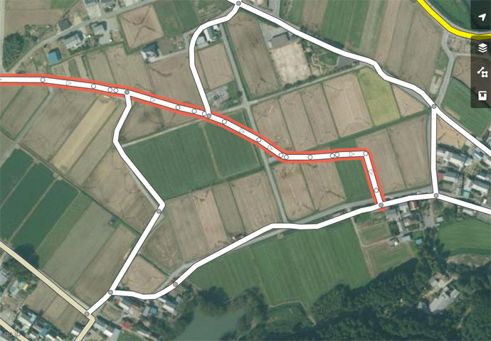
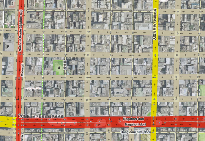
Map Data of Suspect Quality
This is the view in the default OpenStreetMap map editor, with the mapped roads presented over some satellite imagery. It's clear from the imagery that some roads have not been mapped, some have not been mapped well, and some non-existent roads have been added (such as the one shown with a red border in the screenshot above).
You have to be a bit careful about blindly trusting the satellite images, since they can be old or misaligned, but if you trust them, you can just go ahead and start fixing the map to match the imagery. The editor is pretty easy to use once you get the hang of it.
Being a geek, I go a step further than trusting the satellite images. I use road data from the Japanese government, via its Geospatial Information Authority of Japan web site, to build something I can overlay within the OpenStreetMap editor to show me the surveyed location of roads:
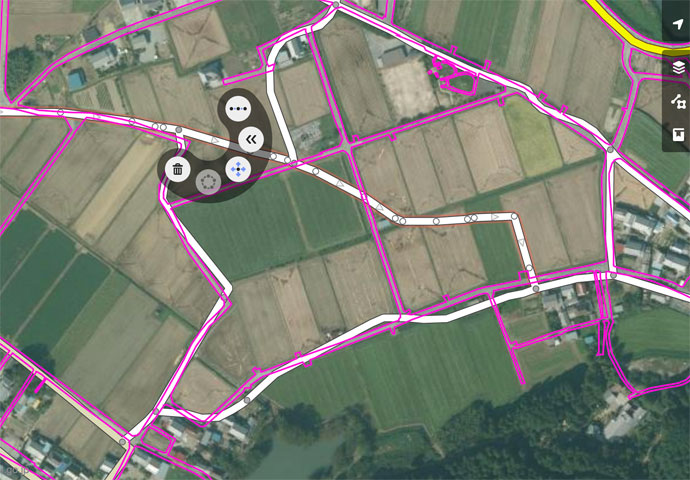
With Reference Data
The data from the Japanese government can also be suspect (old, misaligned, or for proposed roads that don't yet exist), but it's a good sign when this data matches the satellite photo perfectly. So, I start fixing things...
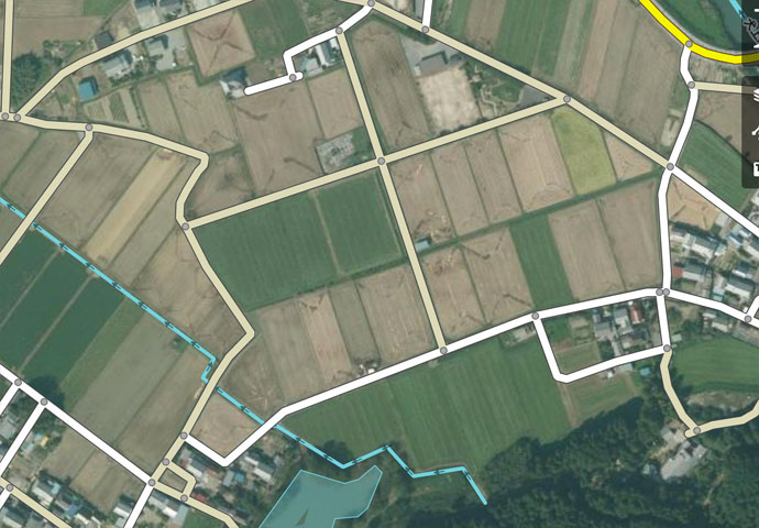
Fixed Result
It takes only a moment to fix the little area seen in the screenshots above, but it's sort of addicting. You're fixing a road that connects to another road that's just as bad, so you start correcting it, and so on. Luckily, Japan is an island nation, so in theory there's a limit to how far it can take me. I tend to get caught in a “just one more fix” loop until I can force myself to stop and leave areas of the map untouched and incorrect. This is difficult for a data geek like me to do.
Here's another example showing poorly-mapped roads not far from the spot above:

Before, but with my road-edge overlay

Better, but the roads seem to be shifted down and to the right a bit

Ah, that's better
mouseover a button to see that image
The difference between “Middle” and “After” is not that the road mapping was moved, but that within the map editor, I switched to a different satellite-imagery layer. There are various layers, and the quality of each varies considerably as you move around. In this case, the first's images were offset to the southeast by about the width of a road, and the second's images weren't. (It could be that neither are correct, but in this case I could compare with the government survey data, and so knew the second one to be correct.)
In writing this post, I realized that I used the wrong set of images to roughly place the lake that pokes in from the right side of the frame... in the “After” view, the lake is in the wrong spot. I've since returned to fix it.
So, after saving a set of updates, it can take some time for the new data to percolate to all the places that use it...
Update Speed to Web-based Maps
Web sites that use OpenStreetMap data can see updates almost immediately... within a minute. Strava seems to have
a slightly longer delay, likely due to intermediate caching in their backend, so updates might take five or ten minutes to appear there. Update: Strava stopped received updates in mid 2017, and from my inquiries, neither Strava nor Mapbox (via which Strava gets OpenStreetMap updates) seem concerned. )-:
Here is another before/after pair of screenshots from Strava, showing tiny part of this epic ride two weeks ago, descending into Osaka on an exceedingly-steep mountain road used by a lot of tourists on foot. It turned out that the OpenStreetMap coverage here was pretty sparse, and I thought to update it because folks on foot would likely appreciate accurate maps when deciding where to trudge up and down.
mouseover a button to see that image
I updated quite a bit of the surrounding area, but scrolling a bit farther away and you can see sparse areas still in need of some mapping TLC.
Update Speed to Route Building
Other uses of OpenStreetMap data take longer to update. For example, GraphHopper, where I make cycling routes, refreshes their routing data only every few days. The maps update visually right away, but the routes they generate won't reflect updates for up to a few days.
I don't know the update schedule for Strava's route builder, but it doesn't seem to be very often. Changes I made two weeks ago are still not reflected in its routes.
Update Speed for Garmin GPS Units
Garmin apparently sells detailed maps for various areas of the world, but I have no experience with these. Rather, on my Garmin 820 cycling computer I use maps derived from OpenStreetMap data, packaged for English-language Garmin devices by a guy in Osaka. Because these devices can't display Japanese natively, his preparation process converts Japanese text to “English” (to romaji). It's quite convenient.
He makes a new version available about twice a month, each time bringing in the accumulated updates. The web page is all in Japanese, but downloading and installing is simple.
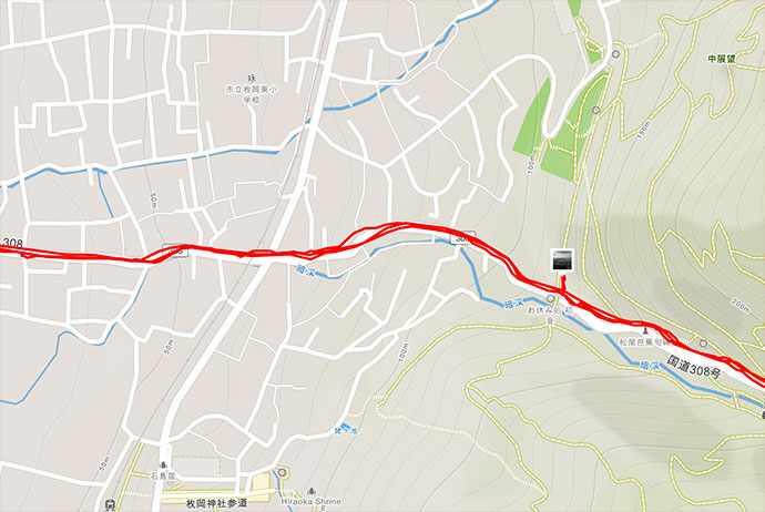
In about the middle of the web page is a grid with a purple background...
The top pair of items are the latest data, the one marked in green is a version that includes contour lines, the one marked in red does not. I use the latter, but a hiker probably wants the former.
Each download zip holds two “*.img” files (“gmapsupp.img” and “gmapsupp_search.img”). After unzipping, just copy the two “*.img” files into your Garmin unit's “Garmin” folder. That's all there is to installing these maps and their updates.
Update Speed for Offline-Map Apps
The two phone apps I mentioned earlier are very convenient because after an initial map download, they don't need an internet connection to work, so you can use them when you're deep in the mountains with no coverage. Both are available on both iOS and Android.
In the case of Guru Maps, the map for all of Japan currently takes about 470 megabytes of storage. With Maps.me, you can load maps by the prefecture level (e.g. state/province). Kyoto Prefecture currently takes 47 megabytes (though the app inexplicably includes “Kyoto Prefecture” under the “Shikoku” region, despite my having reported this bug to them a year ago).
Updates that you (and I and others) make to OpenStreetMap data won't get into these apps very quickly, though. They tend to refresh their maps only once every month or three.
Each app has its strengths. You can record your track with Guru Maps, while Maps.me lets you do turn-by-turn routing (and you can route while offline, too).
Hidden Map Features: One Way(ish) Streets
I've been making updates to OpenStreetMap data like this for a year, and have spent way, way too much time on it. I guess it's my way of trying to give back a bit for all the wonderful stuff I am freely allowed to use. However, there was one part of the updates that was particularly frustrating.
At first the problem may not be apparent...
Lurking Problem
lots of one-way streets.... sort of
To understand the problem, let's look at a typical “one way” street sign in Japan:
Typical “One Way” Sign
The devil is in the details.... the vast vast majority of “one way” signs in Japan are paired with another sign:
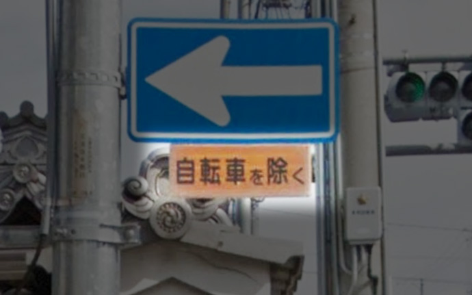
“Except Bicycles”
自転車を除く
Bicycles are allowed to go either direction on such streets, which is, as I said, most one-way streets in Japan. It's quite convenient for cyclists.
I would guess that the little “Except Bicycles” sign is the most common street sign in Japan, since it's added to almost all of the “one way” and “do not enter” signs.
So why do we care about this when mapping? If left as is, automatic routing (such as via the Maps.me phone app or the GraphHopper and Strava web sites) won't utilize these hybrid one-way roads to their fullest extent when routing for bicycles, yielding results that are more inconvenient than they should be, but in the worst case completely disallowing routing through an area that should be allowed.
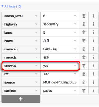
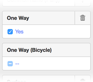
So, the OpenStreetMap editor does have a way to mark such streets as “not one way for bicycles”, but it's not convenient:
Select the street segment
-
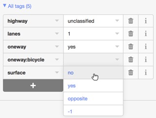
In the left sidebar, scroll down to the “All tags” list. Each street will have its own mix of tags, but if it displays as a one-way street, it'll have a “oneway” tag with a value of “yes” (or in some cases, “-1” or “1” or “true”, which all mean the same as “yes” for our purposes).
As illustrations, here are the tag lists from two random one-way streets:
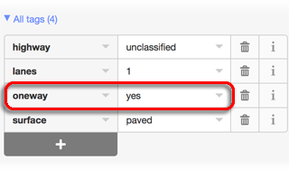
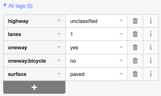
Add a “oneway:bicycle” tag with a “no” value...
1) Click the add-tag “+”
2) Add field “oneway:bicycle”
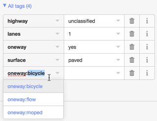
3) Make its value “no”
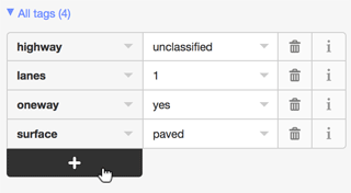
4) Voilà, it's now a one-way road for all but bicycles
One has to be careful to make sure the updates are appropriate. Sometimes very large streets are encoded with separate “roads” for each direction of travel, and each such “road” is one way in its direction for bicycles as well. If these are given a “oneway:bicycle” tag, the value should be “yes”.
It's very nice that “one way for all but bicycles” is possible, but how it's done is really inconvenient, both because of all the steps one must go through to add the notation, and because there's no way to know whether a one-way road has been so notated without scanning all the tags for “oneway:bicycle”.
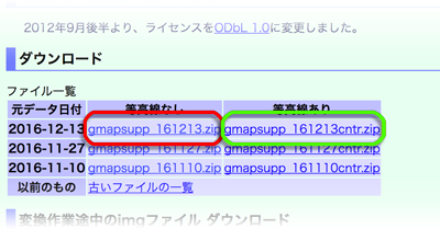
So, when you look at something like this...
Sea of One-Way Streets
that may or may not have been updated for bicycles
... you don't know to what extent, if any, the one-way streets have been updated for bicycles. Even if you have the patience of a saint and check/update them all, will you remember the exact extent of your work after a week or a month, or will you have to spot check for “oneway:bicycle” to remind yourself that you've already done this area? But in either case, how do you know you got them all?
I was in the midst of this frustration yesterday when I tickled myself pink by coming up with a solution:
“Fat” Streets Need to be Updated
I made it so that streets I need to address stand out visually.
To do this, I downloaded the source code to the OpenStreetMap map editor and made a few changes so that non-highway streets that are noted “oneway”, but that have no “oneway:bicycle” notation of any kind, are displayed with exaggerated thickness.
If it's truly one way even for bicycles, I add “oneway:bicycle” with a value of “yes”. This doesn't have an effect on routing, but it denotes to anyone inspecting the tags that the bicycle aspect has been addressed.
But for the typical one-way street, I add “oneway:bicycle” with a value of “no”.
And to make it easier to apply a “oneway:bicycle” tag, I updated the UI so that it's a simple checkbox that cycles among “no tag”, “no”, and “yes”.
And to make it even easier, I made a keyboard shortcut to cycle through the tag values, so I just click a street, tap the key, click the next street and tap the key again, etc.
Once all the “fat” streets are gone, I'm done with an area. Easy peasy! It takes about 15~20 seconds to take care of an area the size seen in the screenshot above.
I've taken care of most of Kyoto, and much of Osaka, but it's still a slow process to do a large area because I have to pan around looking for “fat” streets. If I zoom out too far, the tool exits editing mode and I can't see anything, so I have to be zoomed up, and just pan around.
Anyway, I'm tickeled that I could update the map editor. It's not the kind of programming I'm good at, and that they can build this kind of thing in a browser just boggles my mind. It garners appreciation that there are people out there much smarter than I, and that they donate their talents so freely.

Hat
the path of today's bicycle ride through Kyoto
After long rides on Wednesday and Thursday, and a very hard workout at the gym on Friday, my legs have been extremely sore, so today I went on an easy “recovery ride” in the city, just to get my muscles moving a bit.
It was nice... I go the “KOM” (best registered time) on the highly-sought-after “Jolly Hat” segment.
Doing an image search for “Strava art” yields many impressive results. Some are sort of “fake”, like this famous “cyclist” drawing and this famous “bear” drawing, but many are real and amazing. (I put “fake” in quotes because they are indeed “art” created via “Strava”, but the route you see as a picture is not the path the cyclist actually rode; some parts are created out of thin air with digital trickery, making the result substantially less impressive in my eyes.)
I've been wanting to do one myself, and have vaguely envisioned something impressive, but ran into the slight problem of having absolutely no artistic skill (except with a camera, which doesn't help me here). So over time I kept lowering my sights, and finally got it low enough to make it a reality, copying a simple line drawing of a jolly hat. Even this meager creation taxed my artistic “talents” to their limit. Being a Sunday morning, traffic wasn't too bad; it took about 2½ hours to ride the 35km (22mi) of stop-and-go city streets.
We didn't have the energy to do Christmas Cards this year, so perhaps we'll consdier this it. /-:
 -- Higashiomi, Shiga, Japan -- Copyright 2016 Jeffrey Friedl, https://regex.info/blog/")
Nikon D4 + Nikkor 24-70mm f/2.8 @ 24mm — 1/400 sec, f/6.3, ISO 6400 — map & image data — nearby photos
A Beautiful, Peacful Place
where I've been trying to imagine myself lately
( a deserted road near this place )
So, my web site was down for a few days. Sorry about that.
It doesn't happen often, but this time was a doozy. The ISP hosting my server went bankrupt, and by the time I found out, my server was sitting dead on the floor of a warehouse.
 -- Ushio Kannon Temple (牛尾観音) -- Kyoto, Japan -- Copyright 2016 Jeffrey Friedl, https://regex.info/blog/ -- This photo is licensed to the public under the Creative Commons Attribution-NonCommercial 4.0 International License http://creativecommons.org/licenses/by-nc/4.0/ (non-commercial use is freely allowed if proper attribution is given, including a link back to this page on http://regex.info/ when used online)")
Nikon D4 + Voigtländer 125mm f/2.5 — 1/25 sec, f/2.5, ISO 6400 — map & image data — nearby photos
How I've Felt Lately
another of the wisdom kings at the Ushio Kannon Temple (牛尾観音)
I've got to say, though, I'm actually very thankful.
My web hosting has always been free, a kind, ongoing gift from a former coworker at Yahoo!. Even though we haven't talked for a decade, he's let my server sit in his business and occasionally burn up some of his support staff's time. I've never had to pay for bandwidth, or even think about bandwidth. For perhaps 15 years. I'm so very thankful.
I'm thankful that my brother Steve dropped everything to help me set up an empty virtual server at Amazon Web Services, where in this situation “help me” is used euphemistically to mean “did everything”. I looked into it as a backup a year ago, and the configuration was just too daunting for me to comprehend.
I'm thankful that I had a backup of my system, and that it was up to date. Crashplan doesn't officially support headless clients like I'd need on a remote server, but they tell how to do it and it works, and works well. I was able to restore 50+GB of stuff in about an hour. It seems that both Crashplan and Amazon have fast pipes.
 -- Daichiji Temple (大池寺) -- Koka, Shiga, Japan -- Copyright 2016 Jeffrey Friedl, https://regex.info/blog/")
Nikon D4 + Voigtländer 125mm f/2.5 — 1/400 sec, f/5.6, ISO 5600 — map & image data — nearby photos
My Cup Runnith Over
( please ignore that “my cup tippith over” is probably a more-appropriate caption for this photo )
After setting up my work environment on the new system, and restoring the bulk of things from backup, I then had to set everything up. This is a bit like collecting stuff from a tornado-ravaged house to set up shop at an empty cabin across the street. I had to relearn how to do all the system-administration tasks, moving as I did from Debian to Amazon. Amazon's yum package management system seems easy enough to work with ("YUM" stands for "Yet Uh-nutha' Manager"), and is nicely populated with packages, though it took me a while to figure out “yum list installed”.
I had to re-figure out how to configure the main pieces of my server solution (Apache, MySQL, wordpress) and get them to work together. After doing that, I had to do it all over when I had to bite the bullet and upgrade major versions of the software.
After that it was checking things and correcting the bazillion little things that needed to be re-installed from somewhere, reconfigured, or retwiddled. I'm sure as many more wait to be discovered.
, Shiga Japan ) -- Daichiji Temple (大池寺) -- Koka, Shiga, Japan -- Copyright 2016 Jeffrey Friedl, https://regex.info/blog/")
Nikon D4 + Voigtländer 125mm f/2.5 — 1/400 sec, f/2.5, ISO 1800 — map & image data — nearby photos
Loose Ends
I'm sure there will be many
( at the Daichiji Temple (大池寺), Shiga Japan )
The worst part of the whole thing has been having to deal with email via a web page. I've used emacs to read email for over 30 years, and I'm used to it, but with my machine crashed, I had to revert to interfacing via a web page. Ugh.
In the end I think I've got almost everything back to normal, and in hindsight I'm amazed at how smoothly, relatively speaking, it all went.
One casualty of the move is my (now disabled) Online Image Metadata Viwer. It got a fantastic number of accesses each day, but most were scrapers using it, it seems, to try to access other sites anonymously. I went to great lengths to try to shut this kind of use down, but enough gets through that I just can't risk the bandwidth, now that I'm going to have to pay. I have no idea what kind of bandwidth I used to use, nor how much that would cost now. I guess I'll find out soon enough.

I had quite the little cycling adventure yesterday, venturing into some areas I'd never been, and facing the most heinously-steep road I'd ever seen. The total distance was 191km (118mi), making it my 7th-longest ride ever. This blog post, mostly as a diary for myself, is almost as long.
The distance was no problem, but as it seems with many of my longer rides, lack of time management does me in and I have to kill myself to get back in time for something (in this case Saturday-evening Mass).
The outline of this ride was simple... head down to Iga City, a place I'd never been, because, well, I'd never been there. Then cut across to Nara (which I'd cycled to once, last month), then from there across to Osaka Castle.
By the time I got to Osaka Castle I would have had 140km (87mi) of mountainous riding, but then the return home would be all flat, mostly along nice cycling paths. I've blogged about that 51km (32mi) Osaka-Castle ride a few times, here, here, and here. I thought that even if the ride thus far had tired me out, the flat return taken at my leisure would be no problem. Sigh, if I could only plan better.
Anyway, I knew it would be a long day, so I planned to take it slow and steady.
 on National Route 1 8:00am -- Otsu, Shiga, Japan -- Copyright 2016 Jeffrey Friedl, https://regex.info/blog/")
Cycliq Fly12 — map & image data — nearby photos
Hitching a Ride
relaxing at 47kph (29mph) on National Route 1
8:00am
I felt a bit cheap as I blew past the cyclist seen in the photo above (a screenshot from my bike's front video camera) as I was drafting the truck. I was far enough back that I could easily react safely to anything the truck did, but close enough that the draft effect was huge. Even at 40~50kph, I kept having to use my brakes to maintain the safety buffer.
The big danger to drafting a truck like this is a danger shared by motorcycles: traffic can't see you behind the truck as you approach them, so someone in a rush wanting to pull across your lane the moment the truck passes could hit you. This wasn't a concern this morning because it was rush hour, and there was an SUV right behind me the whole time. (Maybe it was drafting me! 😉 )
So, despite taking the initial steep descent easy, half of this 6km (3.6mi) segment was drafting, so I set a PR by a minute and a half. (I'd feel bad about the drafting if this were a hotly-contested segment on a different kind of road, but drafting is always inviting on this section of the road, and the segment is not at all hotly contested because it didn't exist until I made it a few minutes ago.)
Soon I was in the mountains. It was cold.
 -- Otsu, Shiga, Japan -- Copyright 2016 Jeffrey Friedl, https://regex.info/blog/ -- This photo is licensed to the public under the Creative Commons Attribution-NonCommercial 4.0 International License http://creativecommons.org/licenses/by-nc/4.0/ (non-commercial use is freely allowed if proper attribution is given, including a link back to this page on http://regex.info/ when used online)")
Panasonic LX100 at an effective 24mm — 1/160 sec, f/5.6, ISO 200 — map & image data — nearby photos
Going for that “Winter Cold” Feeling
8:40am - taken while cycling at 22 kph (14 mph)
It was about 4℃/39℉ when I left, and only got colder as I went. It was also misty/rainy.
 -- Otsu, Shiga, Japan -- Copyright 2016 Jeffrey Friedl, https://regex.info/blog/ -- This photo is licensed to the public under the Creative Commons Attribution-NonCommercial 4.0 International License http://creativecommons.org/licenses/by-nc/4.0/ (non-commercial use is freely allowed if proper attribution is given, including a link back to this page on http://regex.info/ when used online)")
Panasonic LX100 at an effective 24mm — 1/125 sec, f/2.2, ISO 200 — map & image data — nearby photos
Evidence of Very Recent Rain
8:40am - taken while cycling at 19 kph (12 mph)
I don't have many photos from the early part of the ride because I didn't want to stop to take them. (What I do have was taken on the fly.) Early in the ride while exiting Kyoto, I realized that I had not had to stop since pulling away from home. Normally in the city you'll get caught by a red light or something, but for whatever reason had gotten lucky so far, so I wondered whether I could make it to the castle in Iga City without stopping.
Getting through Otsu (where I was drafting the truck) required some creative on-the-fly re-routes to avoid red lights, but once I got through that it was mostly rural mountain road the rest of the way.
 -- Koka, Shiga, Japan -- Copyright 2016 Jeffrey Friedl, https://regex.info/blog/ -- This photo is licensed to the public under the Creative Commons Attribution-NonCommercial 4.0 International License http://creativecommons.org/licenses/by-nc/4.0/ (non-commercial use is freely allowed if proper attribution is given, including a link back to this page on http://regex.info/ when used online)")
Panasonic LX100 at an effective 24mm — 1/1600 sec, f/5.6, ISO 200 — map & image data — nearby photos
Last Sun for a While
a misty sleet started just after
8:56am - taken while cycling at 20 kph (13 mph)
 -- Koka, Shiga, Japan -- Copyright 2016 Jeffrey Friedl, https://regex.info/blog/ -- This photo is licensed to the public under the Creative Commons Attribution-NonCommercial 4.0 International License http://creativecommons.org/licenses/by-nc/4.0/ (non-commercial use is freely allowed if proper attribution is given, including a link back to this page on http://regex.info/ when used online)")
Panasonic LX100 at an effective 24mm — 1/125 sec, f/4.5, ISO 200 — map & image data — nearby photos
Tea Fields
8:59am - taken while cycling at 27 kph (17 mph)
The first 50km of the ride were more or less a mild uphill, culminating at Otoki Pass (御斎峠), after which the road pitches down into a 7% descent for 3.6km. This looked like the kind of descent that I would love, and in planning the ride I thought I might KOM it (“King of the Mountain” — register its fastest time), but I abandoned that idea when I lost feeling in my fingers. It was freezing (literally, the temperature was 0℃) and the roads were wet. Not my cup of tea. I went very slowly.
I would love to try the descent again when it's warm and dry. Or at least warm. My fingers were killing me.
From there I had to work my way through the city to the castle:
")
Panasonic LX100 at an effective 24mm — 1/125 sec, f/5.6, ISO 200 — map & image data — nearby photos
Iga Ueno Castle
伊賀上野城
10:11am
 -- Iga, Mie, Japan -- Copyright 2016 Jeffrey Friedl, https://regex.info/blog/ -- This photo is licensed to the public under the Creative Commons Attribution-NonCommercial 4.0 International License http://creativecommons.org/licenses/by-nc/4.0/ (non-commercial use is freely allowed if proper attribution is given, including a link back to this page on http://regex.info/ when used online)")
Panasonic LX100 at an effective 24mm — 1/125 sec, f/4.5, ISO 200 — map & image data — nearby photos
Quiet Saturday Morning
There were a few folks walking around, and one stall selling something that looked warm and tasty. But the ambiance was destroyed by a loudspeaker playing some kind of “welcome to this super lovely place that you should think is super lovely” kind of audio, on a loop. For having a culture with such a deep sense of beauty, Japanese sure know how to destroy it.
Anyway, I was pleased to have made the 62km trip completely nonstop, the wheels of the bike never stopping between when I pulled away from home to when I stopped to take the photos above. I'm geeky that way, to find pleasure in essentially-meaningless “achievements” rooted mostly in luck. My greatest such achievement was doing ⅔ of a loop around Lake Biwa — 125km (78mi) — nonstop, on this ride.
Now that I could feel free to stop, I next did so at a convenience store for a cup of coffee and some lunch (a chicken breast and a junky sweet bread). Then it was off to the city of Nara.
")
Panasonic LX100 at an effective 46mm — 1/125 sec, f/3.2, ISO 200 — map & image data — nearby photos
Keep Left
it seems that Nara has some set cycling routes that this was part of
11:22am
")
Panasonic LX100 at an effective 24mm — 1/125 sec, f/5, ISO 200 — map & image data — nearby photos
Time To Make the Doughnuts
beginning of one of the day's climbs
11:49am
I was happy to start climbing again, to generate some heat, as my fingers and toes were in the midst of a competition to see who could feel colder. I had thick winter socks, thick neoprene toe covers, then my shoes, and then thick fleece covers over those, but still my toes were killing me. I need heated socks, or something.
")
Panasonic LX100 at an effective 26mm — 1/125 sec, f/3.2, ISO 200 — map & image data — nearby photos
New and Old?
11:51am
The running-kid signboard is a common sight along roads in Japan, reminding (imploring) drivers to go slow for the safety of children. This one looks to be commercially made, but the home-made ones can be quite quaint.
Behind it is something that looks decidedly from another era...
")
Panasonic LX100 at an effective 75mm — 1/125 sec, f/3.2, ISO 200 — map & image data — nearby photos
Slightly Creepy
This one shows a police officer and a child with a grotesquely large arm. (Children in Japan are taught to raise one arm above their head when they cross the road, to make themselve more visible.)
Below the people there's a slot... perhaps it's also a trash can? Below that, barely visible, are molded letters saying “Look Right, Look Left”, and below that is an advertisement for “Crazy Motor Works Mikai”.
")
Panasonic LX100 at an effective 32mm — 1/125 sec, f/2.5, ISO 200 — map & image data — nearby photos
Which Should I Take?
11:55am
Between the cities of Iga and Nara are some mountains that I would be crossing at Mima Pass (水間峠). At the pass there's 830m (half a mile) tunnel, or intead one could take the original road up and over that the tunnel bypasses. Along that short stretch of originally road is essentially nothing except one small garage-like building.
The above photo represents a situation I see often, but don't fully understand. Someone clearly intends to block off the road, but two of the three signs say “the road farther ahead is closed to traffic”. (The third sign is about fire safety.) I can understand putting a sign here to warn of a dead end, but why put the barriers here if the road is not closed here?
Secondly, these are put up by the local neighbored association. Do they have the right to take exclusive control of a public road? This is “Nara Prefectural Route 80”, not “Mima Village Private Drive”. And it's not like a small village is trying to prevent through traffic from destroying their ambiance. There is nothing along this stretch of road except for one garage-like building, and at one point access to a farmer's tea field. Why does someone care about blocking traffic on this road?
Finally, what does the sign really mean? The thing being prohibited is “通行”, normally translated as “passage through” or simply “traffic”. Depending on context, this word can apply to all forms of transportation, including pedestrians. It's used on the sign in the cycling “Keep Left” photo above, there meaning simply “travel/movement”. When this word is used on a sign to mark a one-way road, it also applies to bicycles, but not to pedestrians.
In this specific context, I think it refers only to motor vehicles. I don't know why they would want to prohibit motor vehicles on this public road, so I can't really justify why I think they don't mind bicycles and pedestrians, except that they didn't use the completely unambiguous and common “No Entry!” (立入禁止). Had they used that I would not have taken the road less traveled, but they didn't, so I did.
")
Panasonic LX100 at an effective 24mm — 1/125 sec, f/5, ISO 200 — map & image data — nearby photos
Up and Over
11:57am
 -- Nara, Japan -- Copyright 2016 Jeffrey Friedl, https://regex.info/blog/ -- This photo is licensed to the public under the Creative Commons Attribution-NonCommercial 4.0 International License http://creativecommons.org/licenses/by-nc/4.0/ (non-commercial use is freely allowed if proper attribution is given, including a link back to this page on http://regex.info/ when used online)")
Panasonic LX100 at an effective 24mm — 1/125 sec, f/2, ISO 200 — map & image data — nearby photos
The Only Building
on the entire road
(with enough fire wood to last years)
 12:00pm - taken while cycling at 10 kph (7 mph) -- Mima Pass (水間峠) -- Nara, Japan -- Copyright 2016 Jeffrey Friedl, https://regex.info/blog/ -- This photo is licensed to the public under the Creative Commons Attribution-NonCommercial 4.0 International License http://creativecommons.org/licenses/by-nc/4.0/ (non-commercial use is freely allowed if proper attribution is given, including a link back to this page on http://regex.info/ when used online)")
Panasonic LX100 at an effective 24mm — 1/125 sec, f/1.7, ISO 320 — map & image data — nearby photos
Mossy, but Passable
Mima Pass (水間峠)
12:00pm - taken while cycling at 10 kph (7 mph)
 -- Nara, Japan -- Copyright 2016 Jeffrey Friedl, https://regex.info/blog/ -- This photo is licensed to the public under the Creative Commons Attribution-NonCommercial 4.0 International License http://creativecommons.org/licenses/by-nc/4.0/ (non-commercial use is freely allowed if proper attribution is given, including a link back to this page on http://regex.info/ when used online)")
")
Panasonic LX100 at an effective 32mm — 1/80 sec, f/2.2, ISO 200 — map & image data — nearby photos
“Nara Prefectural Route 80”
")
Panasonic LX100 at an effective 75mm — 1/200 sec, f/5.6, ISO 200 — map & image data — nearby photos
Nice View
The bypass road exited the forest and joined to the main road for what would have been a lovely descent except for the screaming headwind on this side of the mountains. It would be with me for much of the rest of the day.
I made my way into Nara, to have lunch at “Manma-tei”, a curry place run by a cycling family, famous among cyclists. I'd met the owner when we were both extras in a cycling-related movie last month, and visited soon after when Manseki brought me on my first trip to Nara.
 -- Nara, Japan -- Copyright 2016 Jeffrey Friedl, https://regex.info/blog/ -- This photo is licensed to the public under the Creative Commons Attribution-NonCommercial 4.0 International License http://creativecommons.org/licenses/by-nc/4.0/ (non-commercial use is freely allowed if proper attribution is given, including a link back to this page on http://regex.info/ when used online)")
Panasonic LX100 at an effective 24mm — 1/200 sec, f/5.6, ISO 200 — map & image data — nearby photos
Photographing Despair
at a closed “Manma-tei” (まんま亭)
It's apparently normally a mad house on a Saturday, but today they were closed for unknown reasons. Not long after I arrived, this couple showed up having ridden from Kobe and seemed to be positively shocked to find it closed. The first thing out of the guy's mouth would be literally translated as “lie!”, but with his tone of voice, the more culturally-realistic translation is closer to “no $&@#ing way!”. They spent several minutes just exchanging such comments between themselves as they tried to come to grip with the reality that they'd have to make different plans.
In the short time before I left, three other cyclists showed up. I guess I'm not the only one to have not checked the web site. Oh well. I had plenty with me. I gave the couple above some tasty sweet-potato bean-paste energy gunk snacks, ate some myself, and headed off to Osaka by way of Nara Park...
 12:46pm - taken while cycling at 17 kph (11 mph) -- Nara Park (奈良公園) -- Nara, Japan -- Copyright 2016 Jeffrey Friedl, https://regex.info/blog/ -- This photo is licensed to the public under the Creative Commons Attribution-NonCommercial 4.0 International License http://creativecommons.org/licenses/by-nc/4.0/ (non-commercial use is freely allowed if proper attribution is given, including a link back to this page on http://regex.info/ when used online)")
Panasonic LX100 at an effective 46mm — 1/500 sec, f/5.6, ISO 200 — map & image data — nearby photos
Arrogant Deer
can't even be bothered to use the crosswalk
Nara Park (奈良公園)
12:46pm - taken while cycling at 17 kph (11 mph)
 -- Nara, Japan -- Copyright 2016 Jeffrey Friedl, https://regex.info/blog/ -- This photo is licensed to the public under the Creative Commons Attribution-NonCommercial 4.0 International License http://creativecommons.org/licenses/by-nc/4.0/ (non-commercial use is freely allowed if proper attribution is given, including a link back to this page on http://regex.info/ when used online)")
Panasonic LX100 at an effective 75mm — 1/160 sec, f/5.6, ISO 200 — map & image data — nearby photos
Crowded
much more so than this time I visited
 -- Nara, Japan -- Copyright 2016 Jeffrey Friedl, https://regex.info/blog/ -- This photo is licensed to the public under the Creative Commons Attribution-NonCommercial 4.0 International License http://creativecommons.org/licenses/by-nc/4.0/ (non-commercial use is freely allowed if proper attribution is given, including a link back to this page on http://regex.info/ when used online)")
Panasonic LX100 at an effective 70mm — 1/125 sec, f/4.5, ISO 200 — map & image data — nearby photos
Kindly Posing
with the selfie-taking girl
I wanted to get some deer poop (chocolate-covered peanuts labeled as “deer poop”) for Anthony, but forgot. )-:
Passing by Nara Station, I paused for a bit to watch a drum/dance performance.
 -- JR奈良駅 -- Nara, Japan -- Copyright 2016 Jeffrey Friedl, https://regex.info/blog/ -- This photo is licensed to the public under the Creative Commons Attribution-NonCommercial 4.0 International License http://creativecommons.org/licenses/by-nc/4.0/ (non-commercial use is freely allowed if proper attribution is given, including a link back to this page on http://regex.info/ when used online)")
Panasonic LX100 at an effective 65mm — 1/500 sec, f/5.6, ISO 200 — map & image data — nearby photos
Performance
to the famous Shima Uta (listen)
")
Panasonic LX100 at an effective 41mm — 1/125 sec, f/5.6, ISO 200 — map & image data — nearby photos
Waiting Their Turn
I knew the road from Nara to Osaka would bring me over a really really steep climb, and I was both looking forward to adding that notch to my belt, and also somewhat scared of it.
It was very tough and very steep, but at one point I thought it wasn't so bad, until I finished and realized that I hadn't even reached that climb yet... I was on a nameless different climb with an average grade of “only” 14%, and for only 600m.
I wasn't sure what to expect for the real climb until I descended out of the forest and saw this across the valley:
")
Panasonic LX100 at an effective 24mm — 1/1000 sec, f/5.6, ISO 200 — map & image data — nearby photos
Abandon Hope All Ye Who Enter Here
I didn't shield the lens well from the sun, so the photos are all washed out, but across the little valley was another mountain with roads that looked like they went more or less straight up:
")
Panasonic LX100 at an effective 75mm — 1/200 sec, f/5.6, ISO 200 — map & image data — nearby photos
Washed Out
As I said, the photos perhaps don't show it well, but this scene struck terror in me. I posted a blurry iPhone version of this photo to the Cycling Kyoto! group on Facebook, with a caption “Shit's About to Get Real”. It's an impressive, imposing sight.
The road through the rice fields right of center is the one that stands out the most at first glance, but that's not The Climb, that's a shorter climb that I would not do this time, but that's now on my list to do sometime.
The climb I would do is more than twice as long, tracing the fold in the mountain that runs up the center of the photo. It's the eastern ascent to Kuragari Pass. I had somehow heard of this place and its ridiculous climb, so it had been on my list to visit.
Before starting that climb I had to finish the descent from the little bump I had done. This part of town had a lot of “doughnut streets”...
")
Panasonic LX100 at an effective 24mm — 1/200 sec, f/5.6, ISO 200 — map & image data — nearby photos
Super Steep
New streets beyond a certain grade have to have some kind of anti-slip feature, such as grooves or, commonly, these ring-shaped indentations. Lots of streets in this area had them.
I didn't know the details at the time, but The Climb I was apprehensive about turns out to be 2.9 km (1.8 miles) at an average grade of only 11%. This is a very steep average over such a long distance, but comparable to some climbs closer to home, such as this. Had I known the details I wouldn't have been so apprehensive, and it turns out that I had no trouble with it. I took it easy and slow.
 -- Ikoma, Nara, Japan -- Copyright 2016 Jeffrey Friedl, https://regex.info/blog/ -- This photo is licensed to the public under the Creative Commons Attribution-NonCommercial 4.0 International License http://creativecommons.org/licenses/by-nc/4.0/ (non-commercial use is freely allowed if proper attribution is given, including a link back to this page on http://regex.info/ when used online)")
Panasonic LX100 at an effective 25mm — 1/200 sec, f/7.1, ISO 200 — map & image data — nearby photos
Plodding Up
source of the smoke seen in the “Washed Out” photo above
2:11pm - taken while cycling at 7 kph (5 mph)
 -- Ikoma, Nara, Japan -- Copyright 2016 Jeffrey Friedl, https://regex.info/blog/ -- This photo is licensed to the public under the Creative Commons Attribution-NonCommercial 4.0 International License http://creativecommons.org/licenses/by-nc/4.0/ (non-commercial use is freely allowed if proper attribution is given, including a link back to this page on http://regex.info/ when used online)")
Panasonic LX100 at an effective 24mm — 1/1600 sec, f/7.1, ISO 200 — map & image data — nearby photos
Looking Back
with an over-the-shoulder shot
2:13pm - taken while cycling at 6 kph (4 mph)
 -- Ikoma, Nara, Japan -- Copyright 2016 Jeffrey Friedl, https://regex.info/blog/ -- This photo is licensed to the public under the Creative Commons Attribution-NonCommercial 4.0 International License http://creativecommons.org/licenses/by-nc/4.0/ (non-commercial use is freely allowed if proper attribution is given, including a link back to this page on http://regex.info/ when used online)")
Panasonic LX100 at an effective 24mm — 1/800 sec, f/7.1, ISO 200 — map & image data — nearby photos
Again
a few minutes later
2:19pm - taken while cycling at 7 kph (5 mph)
 -- Kuragari Pass (暗峠) -- Ikoma, Nara, Japan -- Copyright 2016 Jeffrey Friedl, https://regex.info/blog/")
Panasonic LX100 at an effective 35mm — 1/125 sec, f/2.5, ISO 200 — map & image data — nearby photos
At the Top
Kuragari Pass (暗峠)
The rock has the name of the pass engraved on it. I've seen photo of cyclists posing in front of it, so I know I've heard about this area before. The climb wasn't nearly as bad as I had expected.
 -- Ikoma, Nara, Japan -- Copyright 2016 Jeffrey Friedl, https://regex.info/blog/")
iPhone 6+ + front camera — 1/120 sec, f/2.2, ISO 50 — map & image data — nearby photos
Selfie of Success
 -- Ikoma, Nara, Japan -- Copyright 2016 Jeffrey Friedl, https://regex.info/blog/ -- This photo is licensed to the public under the Creative Commons Attribution-NonCommercial 4.0 International License http://creativecommons.org/licenses/by-nc/4.0/ (non-commercial use is freely allowed if proper attribution is given, including a link back to this page on http://regex.info/ when used online)")
Panasonic LX100 at an effective 24mm — 1/125 sec, f/5, ISO 200 — map & image data — nearby photos
Looking Down on the Pass
from a scenic toll road that passes by
with the road I took emerging from a tunnel at the bottom
 -- Ikoma, Nara, Japan -- Copyright 2016 Jeffrey Friedl, https://regex.info/blog/ -- This photo is licensed to the public under the Creative Commons Attribution-NonCommercial 4.0 International License http://creativecommons.org/licenses/by-nc/4.0/ (non-commercial use is freely allowed if proper attribution is given, including a link back to this page on http://regex.info/ when used online)")
Panasonic LX100 at an effective 75mm — 1/125 sec, f/5.6, ISO 200 — map & image data — nearby photos
Looking Back Toward Nara
I had crossed over all the mountains seen in the photo above, since Iga City is beyond it all. The strip of mountains in the center of the photo is where the “false climb” was. Toward the right, at the foot of that strip of mountains, is a big water tower with two electric towers behind it. The “Washed Out” photo was taken from just in front of those towers.
 section at the top was almost unridable -- Kuragari Pass (暗峠) -- Ikoma, Nara, Japan -- Copyright 2016 Jeffrey Friedl, https://regex.info/blog/ -- This photo is licensed to the public under the Creative Commons Attribution-NonCommercial 4.0 International License http://creativecommons.org/licenses/by-nc/4.0/ (non-commercial use is freely allowed if proper attribution is given, including a link back to this page on http://regex.info/ when used online)")
Panasonic LX100 at an effective 24mm — 1/125 sec, f/3.5, ISO 200 — map & image data — nearby photos
Very Unfriendly Road
a short (60m) section at the top was almost unridable
So, it was time to head down toward Osaka and home, but I thought since I was in the area, I may as well turn around at the bottom and do the climb from the other side as well, just to get them both checked off my list.
Now, before I go on, I have to stress that I like to test myself on steep roads. Really really steep. It perhaps started with the short 21% “Nasty”, and the 32% section here. I often go out looking for new, disgustingly-steep roads, such as I did the other day, or here, and many other rides. I look for the steepest I can find, and ride it. Maybe slowly, but I ride it.
All that being said, nothing prepared me for the horror of this descent. After leaving the pass the road slopes down briskly for a short while, then pitches down like a “death drop” slide at a water park, and just keeps plummeting down. This descent is unrelenting, averaging 18% over 2.1km (1.4mi).
")
Panasonic LX100 at an effective 65mm — 1/125 sec, f/3.5, ISO 200 — map & image data — nearby photos
First Hint of a View
as the road plunges back into darkness in the far background
")
Panasonic LX100 at an effective 75mm — 1/320 sec, f/5.6, ISO 200 — map & image data — nearby photos
Near the Bottom
What horrified me about this descent was not the descent, but thinking of it as an ascent. Had the road been wet the descent certainly would have been horrifying (like the one described here), but as a climb this road felt unreal.
There were multiple sections where the grade exceeded 30% for more than 50m. Any one such section buried in a mild section of road somewhere would turn that climb into a local monster, but these were tied together by 20% and 25% sections. The middle 1.1km of this climb averages 21%, bookmarked by “milder” sections that themselves would be considered beyond extreme to many cyclists.
I'd never seen such unrelenting steepness before, and the thought of climbing it scared the hell out of me. The unrelenting steepness over such a distance made it feel an order of magnitude worse than anything I had ever attempted. 10 times worse.
I felt mentally scarred and paralyzed by the thought of it, but forced myself to turn around at the bottom and head back up.
It was worse than I thought. I simply couldn't do it. I had to stop and rest, and did so for a couple of minutes. But then the problem was how to get started again... it's not easy to clip the shoes back into the pedals on such a steep grade, but with trouble after a few tries I could do it and continue up.
But it didn't last long. It was just too much for me. For the first time ever in my cycling life, a climb was too difficult for me to even finish. I gave up.
It turns out that I got almost half way before failure engulfed me.
Feeling utterly defeated, I headed back down and then plodded across the vast urban expanse of Eastern Osaka.
 3:53pm -- Osaka Castle (大阪城) -- Osaka, Japan -- Copyright 2016 Jeffrey Friedl, https://regex.info/blog/ -- This photo is licensed to the public under the Creative Commons Attribution-NonCommercial 4.0 International License http://creativecommons.org/licenses/by-nc/4.0/ (non-commercial use is freely allowed if proper attribution is given, including a link back to this page on http://regex.info/ when used online)")
Panasonic LX100 at an effective 75mm — 1/125 sec, f/5, ISO 200 — map & image data — nearby photos
Finally Arriving
Osaka Castle (大阪城)
3:53pm
 -- Osaka, Japan -- Copyright 2016 Jeffrey Friedl, https://regex.info/blog/")
iPhone 6+ + front camera — 1/800 sec, f/2.2, ISO 32 — map & image data — nearby photos
Obligatory Selfie
 -- Osaka, Japan -- Copyright 2016 Jeffrey Friedl, https://regex.info/blog/ -- This photo is licensed to the public under the Creative Commons Attribution-NonCommercial 4.0 International License http://creativecommons.org/licenses/by-nc/4.0/ (non-commercial use is freely allowed if proper attribution is given, including a link back to this page on http://regex.info/ when used online)")
Panasonic LX100 at an effective 41mm — 1/125 sec, f/4, ISO 200 — map & image data — nearby photos
Again With the Nicer Camera
sans self
The headwinds and the extra attempt to climb the mountain had put me an hour behind schedule, and I had two hours to make what I had planned to be a relaxing three-hour ride home.
")
Panasonic LX100 at an effective 44mm — 1/500 sec, f/2.8, ISO 200 — map & image data — nearby photos
Start of the Bicycling Path
Kyoto is 50km ahead, with what looks like rain
 -- Osaka, Japan -- Copyright 2016 Jeffrey Friedl, https://regex.info/blog/ -- This photo is licensed to the public under the Creative Commons Attribution-NonCommercial 4.0 International License http://creativecommons.org/licenses/by-nc/4.0/ (non-commercial use is freely allowed if proper attribution is given, including a link back to this page on http://regex.info/ when used online)")
Panasonic LX100 at an effective 26mm — 1/125 sec, f/3.5, ISO 200 — map & image data — nearby photos
Chasing My Shadow
4:20pm - taken while cycling at 23 kph (14 mph)
The wind was strong from my 10 o'clock, but at least not gusty. I should have been able to average 30kph (19mph), but it kept me down to about 25kph (15mph), further putting me behind schedule. The need to rush made this the worst, most-punishing part of the ride.
")
Panasonic LX100 at an effective 24mm — 1/100 sec, f/2.8, ISO 3200 — map & image data — nearby photos
Still More than an Hour Until Home
5:19pm
I got home just before 6:30, threw on some clean clothes that I hoped would mask the smell my body had been cultivating all day, and made it to Mass not all too late. I tried not to sit close to anyone.