
Nikon D4 + 35mm f/1.4 — 1/160 sec, f/14, ISO 1100 — map & image data — nearby photos
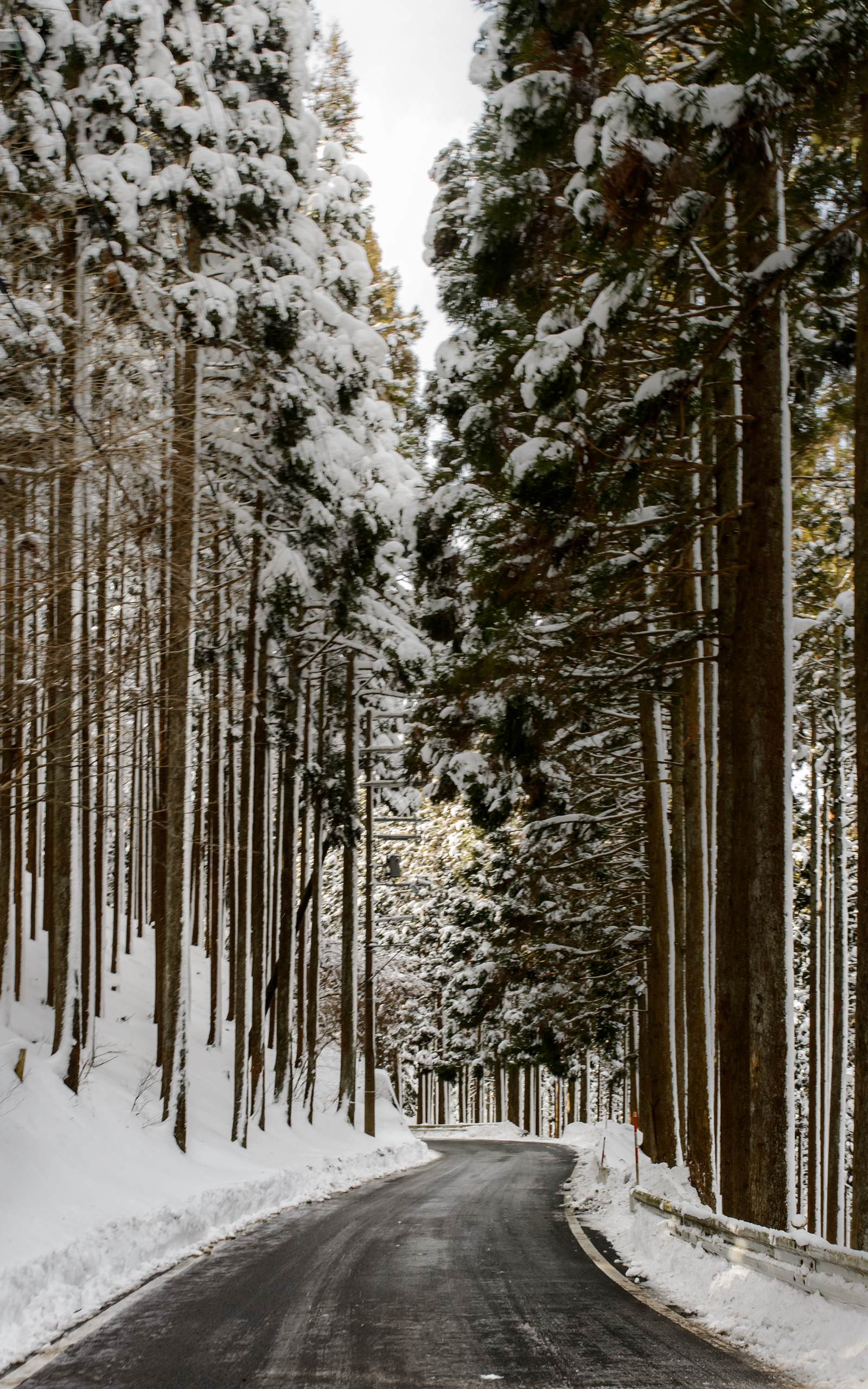
The Road Ahead
is finally downhill
やっと下り坂です(撮影は運転しながら片手で)
( taken one-handed while cycling at 11 km/h )
In part 1 about last weekend's cycling into the mountains north of Kyoto, I ended the story 23km into the journey at the top of the Hanase Pass (花背峠). At 769m it would be the highest point of the trip (a trip that started and ended at an elevation of about 60m).
With a nice downhill to look forward to, I didn't linger long at the pass. After a minute-and-a-half's rest and a selfie, I carried on.
I couldn't let myself build up much speed because the road was quite snowy/icy, so I dragged on the rear brake most of the time. Still, the slow speed allowed me to appreciate the scenery a bit. I suppose it's difficult to see in this next shot, but at times the ground dropped away from the road at perilous rates...
 -- Kyoto, Japan -- Copyright 2015 Jeffrey Friedl, http://regex.info/blog/ -- This photo is licensed to the public under the Creative Commons Attribution-NonCommercial 4.0 International License http://creativecommons.org/licenses/by-nc/4.0/ (non-commercial use is freely allowed if proper attribution is given, including a link back to this page on http://regex.info/ when used online)")
Nikon D4 + 35mm f/1.4 — 1/160 sec, f/14, ISO 800 — map & image data — nearby photos
Looking Off to the Side
道の横
10:58am (23.1 km)
")
Nikon D4 + 35mm f/1.4 — 1/160 sec, f/9, ISO 140 — map & image data — nearby photos
Slick Curves
11:00am - taken one-handed while cycling at 14 km/h
 -- Kyoto, Japan -- Copyright 2015 Jeffrey Friedl, http://regex.info/blog/ -- This photo is licensed to the public under the Creative Commons Attribution-NonCommercial 4.0 International License http://creativecommons.org/licenses/by-nc/4.0/ (non-commercial use is freely allowed if proper attribution is given, including a link back to this page on http://regex.info/ when used online)")
Nikon D4 + 35mm f/1.4 — 1/160 sec, f/9, ISO 100 — map & image data — nearby photos
Pausing to Look Back
振り返りの一時停止
11:00am (23.8km)
The big tower seen above is not far from Hanase Pass where I'd been a few minutes earlier. The tower can be seen from Kyoto (in the hazy clouds in the upper left of this photo), or up close (here). When I took those photos five years ago, I was 100kg of out-of-shape frumpiness, and I'd never in a million years thought I'd bicycle that far.
The turning point for me came 2½ years ago in “Yesterday’s Hike: The Agony Where Bravado Yields, In Spectacular Fashion, To Painful Reality”, after which I vowed to get in shape. Even just two months later I was starting to show progress. I've been at it in various ways for 2½ years, and now at 48 I'm in by far the best shape of my life. Whoo-hoo!
Anyway, I soon descended into the little village on the other side of the mountain...
, taken one-handed while cycling at 25 km/h -- Kyoto, Japan -- Copyright 2015 Jeffrey Friedl, http://regex.info/blog/ -- This photo is licensed to the public under the Creative Commons Attribution-NonCommercial 4.0 International License http://creativecommons.org/licenses/by-nc/4.0/ (non-commercial use is freely allowed if proper attribution is given, including a link back to this page on http://regex.info/ when used online)")
Nikon D4 + 35mm f/1.4 — 1/320 sec, f/9, ISO 100 — map & image data — nearby photos
Entering a Small Village
11:05am (25.3km), taken one-handed while cycling at 25 km/h
 11:05am (25.5km), taken one-handed while cycling at 27 km/h -- Kyoto, Japan -- Copyright 2015 Jeffrey Friedl, http://regex.info/blog/ -- This photo is licensed to the public under the Creative Commons Attribution-NonCommercial 4.0 International License http://creativecommons.org/licenses/by-nc/4.0/ (non-commercial use is freely allowed if proper attribution is given, including a link back to this page on http://regex.info/ when used online)")
Nikon D4 + 35mm f/1.4 — 1/400 sec, f/9, ISO 100 — map & image data — nearby photos
Flyby Shrine Visit
entrance to the Hiyoshi Shrine (日吉神社)
11:05am (25.5km), taken one-handed while cycling at 27 km/h
I'd visited the shrine beyond that gate five years ago and had thought to do so again on this trip, but didn't. Judging by the amount of undisturbed snow on the path, (which goes 250m back up into the mountains to the shrine), it's probably just as well that I didn't.
In preparing for the trip I imagined a slow lazy ride, with many stops to check out hopefully-photogenic mountain temples and shrines. When I passed this shrine it was only 11am, but I was already starting to worry about the time: I had to get home and cleaned up in time to make it to 5pm Mass. According to my original plan, I still have 80km of unknown terrain left to ride.
One stop I would have made was at the cafe “Cowbell” moments later. Unfortunately, they were closed:
 -- Kyoto, Japan -- Copyright 2015 Jeffrey Friedl, http://regex.info/blog/ -- This photo is licensed to the public under the Creative Commons Attribution-NonCommercial 4.0 International License http://creativecommons.org/licenses/by-nc/4.0/ (non-commercial use is freely allowed if proper attribution is given, including a link back to this page on http://regex.info/ when used online)")
Nikon D4 + 35mm f/1.4 — 1/400 sec, f/9, ISO 100 — map & image data — nearby photos
Cafe Cowbell
喫茶カウベル
11:05am (25.7km)
I would have liked a cup of coffee, but had no choice but to press on.
Fifteen minutes of mostly downhill later, I decided to pause to put on some warmer clothes. As expected, I'd gotten quite chilly in the half-hour descent. My toes were the worst, but otherwise I was pretty okay... just chilly. But not knowing what to expect going forward, I thought it would be prudent to put on another layer.
So, I broke out some things I'd bought in preparation for the trip: a Uniqlo Ultra-Light Down Half Coat (it weighs nothing and can roll up into a ball) under my windbreaker, and Uniqlo Warm Easy Cargo Pants (fleece-lined polyester sporty winter pants) over my Under Armour leggings.
I snapped a photo of my legs just to mark the location on my tracklog.
 -- Kyoto, Japan -- Copyright 2015 Jeffrey Friedl, http://regex.info/blog/ -- This photo is licensed to the public under the Creative Commons Attribution-NonCommercial 4.0 International License http://creativecommons.org/licenses/by-nc/4.0/ (non-commercial use is freely allowed if proper attribution is given, including a link back to this page on http://regex.info/ when used online)")
Nikon D4 + 35mm f/1.4 — 1/1000 sec, f/2.8, ISO 100 — map & image data — nearby photos
Tracklog-Marking Photo
11:22am (29.9km)
I continued on, and after 20 minutes of ups and downs, I found a place to have that cup of coffee.
 - 京都花背山村都市 交流 の森 -- 京都花背山村都市交流の森 -- Kyoto, Japan -- Copyright 2015 Jeffrey Friedl, http://regex.info/blog/ -- This photo is licensed to the public under the Creative Commons Attribution-NonCommercial 4.0 International License http://creativecommons.org/licenses/by-nc/4.0/ (non-commercial use is freely allowed if proper attribution is given, including a link back to this page on http://regex.info/ when used online)")
Nikon D4 + 35mm f/1.4 — 1/160 sec, f/13, ISO 400 — map & image data — nearby photos
First Real Break
11:40am (34.2km) - 京都花背山村都市交流の森
")
Nikon D4 + 35mm f/1.4 — 1/160 sec, f/3.2, ISO 2500 — map & image data — nearby photos
Inviting Scene
 -- 京都花背山村都市交流の森 -- Kyoto, Japan -- Copyright 2015 Jeffrey Friedl, http://regex.info/blog/ -- This photo is licensed to the public under the Creative Commons Attribution-NonCommercial 4.0 International License http://creativecommons.org/licenses/by-nc/4.0/ (non-commercial use is freely allowed if proper attribution is given, including a link back to this page on http://regex.info/ when used online)")
Nikon D4 + 35mm f/1.4 — 1/160 sec, f/3.2, ISO 3200 — map & image data — nearby photos
Fogged Over Lens
it's what happens when you bring a cold lens into a warm room
( the room was actually quite cold until you got near the heaters, which is why I suspect the prior photo came out clear )
My shirts were well soaked, so I took the opportunity to try to dry them by hanging them over chairs near the heater. I was the only customer, yet after a while one of the workers came to ask me to use the heater in the lobby (the cafe being part of a larger semi-public non-profit recreational area), commenting that the cafe was “for customers only”. I looked at her incredulously as I pointed to the coffee I was still enjoying. Geez. She and another worker then helped arrange my stuff for better drying.
This was my first real rest since starting in earnest. I was there for 29 minutes.
, taken one-handed while cycling at 21 km/h -- Kyoto, Japan -- Copyright 2015 Jeffrey Friedl, http://regex.info/blog/ -- This photo is licensed to the public under the Creative Commons Attribution-NonCommercial 4.0 International License http://creativecommons.org/licenses/by-nc/4.0/ (non-commercial use is freely allowed if proper attribution is given, including a link back to this page on http://regex.info/ when used online)")
Nikon D4 + 35mm f/1.4 — 1/160 sec, f/13, ISO 140 — map & image data — nearby photos
A Side Road I'll Have To Investigate Some Day
the map shows a temple about 2km in
12:21pm (36.4km), taken one-handed while cycling at 21 km/h
, taken one-handed while cycling at 12 km/h -- Kyoto, Japan -- Copyright 2015 Jeffrey Friedl, http://regex.info/blog/ -- This photo is licensed to the public under the Creative Commons Attribution-NonCommercial 4.0 International License http://creativecommons.org/licenses/by-nc/4.0/ (non-commercial use is freely allowed if proper attribution is given, including a link back to this page on http://regex.info/ when used online)")
Nikon D4 + 35mm f/1.4 — 1/160 sec, f/13, ISO 280 — map & image data — nearby photos
Typical Valley Scene
12:26pm (38.5), taken one-handed while cycling at 12 km/h
 -- Kyoto, Japan -- Copyright 2015 Jeffrey Friedl, http://regex.info/blog/ -- This photo is licensed to the public under the Creative Commons Attribution-NonCommercial 4.0 International License http://creativecommons.org/licenses/by-nc/4.0/ (non-commercial use is freely allowed if proper attribution is given, including a link back to this page on http://regex.info/ when used online)")
Nikon D4 + 35mm f/1.4 — 1/160 sec, f/11, ISO 160 — map & image data — nearby photos
Time to Check the Map
12:30pm (39.4km)
A cursory look at a map makes it appear that the road I wanted to take was the main path that goes straight here, but in reality it's a 90-degree right turn. I knew I wanted to get to Route 367 so I'm sure I would have been fine without my iPad's map, but I was happy to stop to confirm.
There had been lots of up and down segments — as mountains are apt to do — but I knew I had another major pass to eventually ascend to, and the moment I turned onto Route 110 I knew the ascent had started...
, taken one-handed while cycling at 14 km/h -- Kyoto, Japan -- Copyright 2015 Jeffrey Friedl, http://regex.info/blog/ -- This photo is licensed to the public under the Creative Commons Attribution-NonCommercial 4.0 International License http://creativecommons.org/licenses/by-nc/4.0/ (non-commercial use is freely allowed if proper attribution is given, including a link back to this page on http://regex.info/ when used online)")
Nikon D4 + 35mm f/1.4 — 1/160 sec, f/11, ISO 110 — map & image data — nearby photos
Start of the Next Major Ascent
the next hour would be brutal
ここから能見峠まではめっちゃひどい
12:31pm (39.4km), taken one-handed while cycling at 14 km/h
, taken one-handed while cycling at 18 km/h -- Kyoto, Japan -- Copyright 2015 Jeffrey Friedl, http://regex.info/blog/ -- This photo is licensed to the public under the Creative Commons Attribution-NonCommercial 4.0 International License http://creativecommons.org/licenses/by-nc/4.0/ (non-commercial use is freely allowed if proper attribution is given, including a link back to this page on http://regex.info/ when used online)")
Nikon D4 + 35mm f/1.4 — 1/160 sec, f/11, ISO 500 — map & image data — nearby photos
Road Getting Nasty
12:33pm (40km), taken one-handed while cycling at 18 km/h
, taken one-handed while cycling at 17 km/h -- Kyoto, Japan -- Copyright 2015 Jeffrey Friedl, http://regex.info/blog/ -- This photo is licensed to the public under the Creative Commons Attribution-NonCommercial 4.0 International License http://creativecommons.org/licenses/by-nc/4.0/ (non-commercial use is freely allowed if proper attribution is given, including a link back to this page on http://regex.info/ when used online)")
Nikon D4 + 35mm f/1.4 — 1/160 sec, f/11, ISO 200 — map & image data — nearby photos
12:36pm (41.1km), taken one-handed while cycling at 17 km/h
, taken one-handed while cycling at 15 km/h -- Kyoto, Japan -- Copyright 2015 Jeffrey Friedl, http://regex.info/blog/ -- This photo is licensed to the public under the Creative Commons Attribution-NonCommercial 4.0 International License http://creativecommons.org/licenses/by-nc/4.0/ (non-commercial use is freely allowed if proper attribution is given, including a link back to this page on http://regex.info/ when used online)")
Nikon D4 + 35mm f/1.4 — 1/160 sec, f/11, ISO 720 — map & image data — nearby photos
Splat!
落雪でピシャ!
12:37pm (41.4km), taken one-handed while cycling at 15 km/h
It was clear weather, but throughout the trip, clumps of snow would fall onto the road from the trees in big splats. My luck in avoiding them was gone with the shot above, as it made a direct hit on me and the camera. I didn't have anything to clean the ice off the front of the lens, and didn't want to stop anyway, so I just left it.
, taken one-handed while cycling at 16 km/h -- Kyoto, Japan -- Copyright 2015 Jeffrey Friedl, http://regex.info/blog/ -- This photo is licensed to the public under the Creative Commons Attribution-NonCommercial 4.0 International License http://creativecommons.org/licenses/by-nc/4.0/ (non-commercial use is freely allowed if proper attribution is given, including a link back to this page on http://regex.info/ when used online)")
Nikon D4 + 35mm f/1.4 — 1/160 sec, f/11, ISO 400 — map & image data — nearby photos
Snowy Lens, Snowy Road
12:39pm (41.7km), taken one-handed while cycling at 16 km/h
, taken one-handed while cycling at 13 km/h -- Kyoto, Japan -- Copyright 2015 Jeffrey Friedl, http://regex.info/blog/ -- This photo is licensed to the public under the Creative Commons Attribution-NonCommercial 4.0 International License http://creativecommons.org/licenses/by-nc/4.0/ (non-commercial use is freely allowed if proper attribution is given, including a link back to this page on http://regex.info/ when used online)")
Nikon D4 + 35mm f/1.4 — 1/160 sec, f/11, ISO 180 — map & image data — nearby photos
12:39pm (41.8km), taken one-handed while cycling at 13 km/h
, taken one-handed while cycling at 11 km/h -- Kyoto, Japan -- Copyright 2015 Jeffrey Friedl, http://regex.info/blog/ -- This photo is licensed to the public under the Creative Commons Attribution-NonCommercial 4.0 International License http://creativecommons.org/licenses/by-nc/4.0/ (non-commercial use is freely allowed if proper attribution is given, including a link back to this page on http://regex.info/ when used online)")
Nikon D4 + 35mm f/1.4 — 1/160 sec, f/11, ISO 560 — map & image data — nearby photos
Tough Riding
12:41pm (42.4km), taken one-handed while cycling at 11 km/h
It was difficult to ride smoothly, as the semi-hard snow/ice/slush was thick and the tire had to cut through it. Sometimes it would “grab” the tire and force it one way or the other as if in a rut, so I had to spend more effort to keep control.
Still, it was all really quite pleasant, though that feeling wouldn't last long...
, taken one-handed while cycling at 7 km/h -- Kyoto, Japan -- Copyright 2015 Jeffrey Friedl, http://regex.info/blog/ -- This photo is licensed to the public under the Creative Commons Attribution-NonCommercial 4.0 International License http://creativecommons.org/licenses/by-nc/4.0/ (non-commercial use is freely allowed if proper attribution is given, including a link back to this page on http://regex.info/ when used online)")
Nikon D4 + 35mm f/1.4 — 1/160 sec, f/10, ISO 200 — map & image data — nearby photos
This is Just Ridiculous
horrible conditions with a 20%+ slope
12:47pm (43.4km), taken one-handed while cycling at 7 km/h
I'd been stopping much more frequently than on the initial ascent up to Hanase Pass, and the refreshed feeling from the rest lasted much less. I was getting tired.
It eventually dawned on me that perhaps I should eat something. So far I'd had just a cup of coffee at home before leaving, and a cup of coffee at the cafe. I normally don't eat breakfast or lunch; unless a social occasion dictates otherwise, I eat when I feel hungry, not when the clock says everyone should eat. For me that means I generally eat just dinner.
I'm quite used to doing a day full of heavy exercise without having eaten anything, and I don't know that today was any different. I didn't feel hungry and didn't know whether eating something would impact my level of energy, but with not knowing what the route held, I thought it prudent to have a candybar.
 -- Kyoto, Japan -- Copyright 2015 Jeffrey Friedl, http://regex.info/blog/ -- This photo is licensed to the public under the Creative Commons Attribution-NonCommercial 4.0 International License http://creativecommons.org/licenses/by-nc/4.0/ (non-commercial use is freely allowed if proper attribution is given, including a link back to this page on http://regex.info/ when used online)")
Nikon D4 + 35mm f/1.4 — 1/8000 sec, f/1.4, ISO 100 — map & image data — nearby photos
Breakfast and Lunch
今日の初食事
1:01pm (44.0km)
I didn't bring along anything to drink, and Japan's seemingly-ubiquitous vending machines were nowhere to be seen in the last few hours, so I ate some snow along with my frozen Snickers.
It was a picturesque spot for a meal.
")
I soon felt better, not due to the Snickers, but because I reached Nomi Pass (能見峠) nine minutes later...
 -- Kyoto, Japan -- Copyright 2015 Jeffrey Friedl, http://regex.info/blog/ -- This photo is licensed to the public under the Creative Commons Attribution-NonCommercial 4.0 International License http://creativecommons.org/licenses/by-nc/4.0/ (non-commercial use is freely allowed if proper attribution is given, including a link back to this page on http://regex.info/ when used online)")
Nikon D4 + 35mm f/1.4 — 1/6400 sec, f/1.4, ISO 100 — map & image data — nearby photos
Nomi Pass
能見峠 at 653m
1:12pm (44.6km)
It took about 42 minutes to get here from the turnoff, 25 of which were actually riding. Strava says that I am “KOM” (King of the Mountain) for this segment this year, which in this case must mean that I'm the first person to do it this year. Others in the Kyoto Cycling group can do it finish-to-end in under 14 minutes, though I suppose these snowy conditions might slow even them down a bit.
 -- Kyoto, Japan -- Copyright 2015 Jeffrey Friedl, http://regex.info/blog/ -- This photo is licensed to the public under the Creative Commons Attribution-NonCommercial 4.0 International License http://creativecommons.org/licenses/by-nc/4.0/ (non-commercial use is freely allowed if proper attribution is given, including a link back to this page on http://regex.info/ when used online)")
Nikon D4 + 35mm f/1.4 — 1/5000 sec, f/1.4, ISO 100 — map & image data — nearby photos
Small Village
the white spot in the center of the frame is a small village the road eventually goes through
1:13pm (44.7km)
 -- Kyoto, Japan -- Copyright 2015 Jeffrey Friedl, http://regex.info/blog/ -- This photo is licensed to the public under the Creative Commons Attribution-NonCommercial 4.0 International License http://creativecommons.org/licenses/by-nc/4.0/ (non-commercial use is freely allowed if proper attribution is given, including a link back to this page on http://regex.info/ when used online)")
Nikon D4 + 35mm f/1.4 — 1/4000 sec, f/1.4, ISO 100 — map & image data — nearby photos
Steep Descent
not exactly your best cycling conditions
1:15pm (45.1km)
, taken one-handed while cycling at 17 km/h -- Kyoto, Japan -- Copyright 2015 Jeffrey Friedl, http://regex.info/blog/ -- This photo is licensed to the public under the Creative Commons Attribution-NonCommercial 4.0 International License http://creativecommons.org/licenses/by-nc/4.0/ (non-commercial use is freely allowed if proper attribution is given, including a link back to this page on http://regex.info/ when used online)")
Nikon D4 + 35mm f/1.4 — 1/8000 sec, f/1.4, ISO 100 — map & image data — nearby photos
Entering the Village
1:24pm (47.6km), taken one-handed while cycling at 17 km/h
 1:28pm (49.1km) -- Kyoto, Japan -- Copyright 2015 Jeffrey Friedl, http://regex.info/blog/ -- This photo is licensed to the public under the Creative Commons Attribution-NonCommercial 4.0 International License http://creativecommons.org/licenses/by-nc/4.0/ (non-commercial use is freely allowed if proper attribution is given, including a link back to this page on http://regex.info/ when used online)")
Nikon D4 + 35mm f/1.4 — 1/5000 sec, f/1.4, ISO 100 — map & image data — nearby photos
Shikobuchi Shrine (志古淵神社)
1:28pm (49.1km)
I didn't have much interest in shrines or temples at this point, but looked around for a vending machine. I really wanted something to drink and I was getting tired of eating snow.
There wasn't one at the shrine, nor at the Kyoto City ward office across the street (yes, officially I've been in Kyoto City the entire trip), but happily I came across one before leaving the village...
 -- Kyoto, Japan -- Copyright 2015 Jeffrey Friedl, http://regex.info/blog/ -- This photo is licensed to the public under the Creative Commons Attribution-NonCommercial 4.0 International License http://creativecommons.org/licenses/by-nc/4.0/ (non-commercial use is freely allowed if proper attribution is given, including a link back to this page on http://regex.info/ when used online)")
Nikon D4 + 35mm f/1.4 — 1/250 sec, f/8, ISO 100 — map & image data — nearby photos
Thumbs Up
for not dying of dehydration
1:34pm (49.2km)
15 minutes of some ups but mostly downs later, I came to Route 367. I was feeling great.
, taken one-handed while cycling at 25 km/h -- Otsu, Shiga, Japan -- Copyright 2015 Jeffrey Friedl, http://regex.info/blog/ -- This photo is licensed to the public under the Creative Commons Attribution-NonCommercial 4.0 International License http://creativecommons.org/licenses/by-nc/4.0/ (non-commercial use is freely allowed if proper attribution is given, including a link back to this page on http://regex.info/ when used online)")
Nikon D4 + 35mm f/1.4 — 1/200 sec, f/8, ISO 100 — map & image data — nearby photos
Arriving at Route 367
1:53pm (55.4), taken one-handed while cycling at 25 km/h
 -- Otsu, Shiga, Japan -- Copyright 2015 Jeffrey Friedl, http://regex.info/blog/ -- This photo is licensed to the public under the Creative Commons Attribution-NonCommercial 4.0 International License http://creativecommons.org/licenses/by-nc/4.0/ (non-commercial use is freely allowed if proper attribution is given, including a link back to this page on http://regex.info/ when used online)")
Nikon D4 + 35mm f/1.4 — 1/500 sec, f/8, ISO 100 — map & image data — nearby photos
Easy But Unfun
1:56pm (55.6km)
I've driven on this road many times... it gets a lot of traffic, including buses and lots of dumptrucks, but at times it's fairly narrow, so I didn't think it'd be all that pleasant on a bicycle, especially considering that I'd had to share the entire last hour of road with only three cars and one motorcycle.
But I was feeling great because it's downhill all the way to Kyoto; all the hard work was behind me, and now I just had to coast home.
Or so I thought.
 -- Otsu, Shiga, Japan -- Copyright 2015 Jeffrey Friedl, http://regex.info/blog/ -- This photo is licensed to the public under the Creative Commons Attribution-NonCommercial 4.0 International License http://creativecommons.org/licenses/by-nc/4.0/ (non-commercial use is freely allowed if proper attribution is given, including a link back to this page on http://regex.info/ when used online)")
Nikon D4 + 35mm f/1.4 — 1/320 sec, f/8, ISO 100 — map & image data — nearby photos
“Kyoto 34km”
2:08pm (58.4km)
I don't know why I had it in my mind that it was downhill from here, because it's not at all. It's mostly uphill, though broken more or less into smaller ups and downs. The ups felt very long, and the downs not very “down”... I could never get up much of a coast, and even some downhills felt like they were uphill.
The mismatch between expectation and reality is what really wore me out. That, and the saddle of my bike.... my rear was really hurting by now.
Then we had tunnels.
 -- Otsu, Shiga, Japan -- Copyright 2015 Jeffrey Friedl, http://regex.info/blog/ -- This photo is licensed to the public under the Creative Commons Attribution-NonCommercial 4.0 International License http://creativecommons.org/licenses/by-nc/4.0/ (non-commercial use is freely allowed if proper attribution is given, including a link back to this page on http://regex.info/ when used online)")
Nikon D4 + 35mm f/1.4 — 1/160 sec, f/9, ISO 1000 — map & image data — nearby photos
One of Many
2:19pm (61.3km)
Not thinking I'd need them on a daylight trip, I didn't bring my lights. This turned out to be a mistake, because at times it was so dark inside that I literally could not see what I was riding on. With all the traffic, I didn't feel safe to ride on the narrow road without a light (even my orange jacket became a subdued dull gray in the tunnel lighting), so I “road” on the sort-of side curb that was perhaps two feet wide.
The lights in the tunnels are spaced for maximum efficiency, which is perfect if they're all working. If one goes out, it's utterly pitch black for a short segment of road. During these times, I just kept my hand on the side of the tunnel and felt my way along. It's not a particularly fast way to travel, but it has the nice side effect of keeping me alive.
More ups (always ups) and downs later, finally at about 2:40, I exited yet another tunnel to find a monster twisty descent waiting for me. Here even coasting I'd pick up considerable speed, but the impressive hairpin turns made speed dangerous, so I kept it relatively slow... I maxed out at 57kph prior to the first hairpin.
(I did snap a few pictures while in the hairpins, at a relatively-mild 32kph, but they don't really show anything but the “caution” strips painted across the road, so I'm not bothering to include them here.)
, taken one-handed while cycling at 50 km/h -- Otsu, Shiga, Japan -- Copyright 2015 Jeffrey Friedl, http://regex.info/blog/ -- This photo is licensed to the public under the Creative Commons Attribution-NonCommercial 4.0 International License http://creativecommons.org/licenses/by-nc/4.0/ (non-commercial use is freely allowed if proper attribution is given, including a link back to this page on http://regex.info/ when used online)")
Nikon D4 + 35mm f/1.4 — 1/160 sec, f/9, ISO 140 — map & image data — nearby photos
Kyoto's “I Fall” Tower
and its flight of 308 steps
2:45pm (68.6km), taken one-handed while cycling at 50 km/h
When I came across this big cell tower and its long stairs, I opted not to pause to climb to the top as I did once before. Perhaps next time. 😉
My original route called for me to turn at Tochu (途中)... I love that name. It's a village in the middle of nowhere in the mountains, and the name literally means “on the way” or “in progress”. Every time I drive by I think it's well named... I'm on the way home, or on the way somewhere. I'm never there.
Anyway, I had been planning to cut over to Lake Biwa and return to Kyoto that way, but that would add 10km to my trip, and some steep ascents. With 5pm Mass looming, I didn't think I had the time, so I continued straight on Rt 367.
If I wasn't pressed on time I would have done my original route. I was tired, for sure, but that was part of the point. The only real problem I had was my rear end did not like sitting on the seat any more, so when a downhill segment afforded the opportunity, I'd stand and coast just to get some relief.
My wrists were also quite achy, leaning on the handlebars as I'd been for the last six hours.
 -- Kyoto, Japan -- Copyright 2015 Jeffrey Friedl, http://regex.info/blog/ -- This photo is licensed to the public under the Creative Commons Attribution-NonCommercial 4.0 International License http://creativecommons.org/licenses/by-nc/4.0/ (non-commercial use is freely allowed if proper attribution is given, including a link back to this page on http://regex.info/ when used online)")
Nikon D4 + 35mm f/1.4 — 1/160 sec, f/9, ISO 125 — map & image data — nearby photos
Feeling Closer to Home
3:07pm (77.1km)
This is the convenience store we always stop at when going through Ohara with the family, such as on a family outing to the Sanzen'in Temple, and the one we stopped at two weeks ago when out with folks from Cycling Kyoto on my first “real” bike ride.
30 minutes and 14km of mostly (but not all) down-ish later, I was home.
, taken one-handed while cycling at 21 km/h -- Kyoto, Japan -- Copyright 2015 Jeffrey Friedl, http://regex.info/blog/ -- This photo is licensed to the public under the Creative Commons Attribution-NonCommercial 4.0 International License http://creativecommons.org/licenses/by-nc/4.0/ (non-commercial use is freely allowed if proper attribution is given, including a link back to this page on http://regex.info/ when used online)")
Nikon D4 + 35mm f/1.4 — 1/160 sec, f/11, ISO 220 — map & image data — nearby photos
Home
3:44pm (91.0km), taken one-handed while cycling at 21 km/h
I parked the bike and my rear end was happy for the relief. I was dead tired, but still shocked at how difficult it was to walk up one flight of steps... I had to consciously work to lift myself each step. This was unexpected.
I still managed to snap a photo of myself at the end.

Nikon D4 + 35mm f/1.4 — 1/160 sec, f/1.4, ISO 1400 — map & image data — nearby photos
Tired and Soaked to the Bone
3:49pm
I dumped everything but the shoes, helmet, sunglasses, and camera into the washing machine, and while a bath was being drawn, ate a bowl of cereal.
The tracklog-analysis software I wrote for Lightroom after the trip gives the following stats:
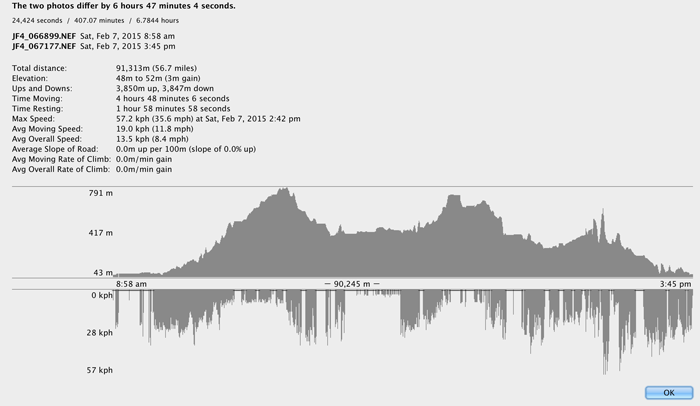
Distance ridden: 91.3km. (The 90.2km shown at the base of the graph is distance without accounting for elevation changes. To account for how much distance was actually traveled, one must bring in Pythagoras and such, you know.)
Total time: 6.8 hours (4.8 riding, 2 resting, though 20 minutes of the rest was before I really started). It's interesting to note that it took longer to write this one post than it did to do the whole ride.
Elevation climbed: 3,850 meters. (Update: it turns out that the elevation climbed was actually only about 1,500 meters, and that Strava wildly inflates elevation gain.)
Anything with elevation must be taken with a grain of salt, because GPS (or in my case GPS/GLONASS) receivers are not very accurate in this respect. It's tempting to look at data like this and take it at face value, but even a highly-accurate unit set down in an open field will record a “track” drifting around the local area in three dimensions.
One must also consider how a tracklog is inspected. Considering that there's that natural small drift even when stationary, one must make a best guess at what constitutes “movement”?
I uploaded my tracklog to Strava, and their analysis of the distance and time were completely different from mine. I've sent them a note to ask about their methods.
Aftermath
My inner thighs really hurt... not the kind of “I had a great workout and now I'm pooped” hurt, but full-on “Mommy make it stop!” pain. A long hot bath helped, but I knew I'd be hurting the next day.
Except I didn't. I was fine on Sunday, with no aches at all. I even went for a bike ride with Anthony.
I was fine on Monday as well for my normal workout, starting with a warmup of 65 pushups in three minutes, then a group workout in the “hot studio” where Hot Yoga is normally done. Even during the leg workout... about 50 squats were not a problem.
But everything changed when we started to do lunges. Wow, it hurt. We didn't do that many, but I was left in a sniveling pile of pain. It's been several days since then, and my inner thighs still hurt... the lunges “awoke” the pain, I guess.
Nice writeup! I’m impressed that even though to wanted to keep the weight down you took a huge DSLR and fast lens 😀
I seriously doubt that you were going 21 kph on a 26 gradient ascent. No one can, not even the best professional climber, not even Lance Armstrong in full EPO. Anyway it is a pleasure to look at the pictures and read your story. i press the LIKE button!
I totally agree, I could never do that (unless it was right after a big downhill section that let me pick up speed 😉 ). I’m not sure what prompts this comment (26 gradient?), but perhaps it was the “This is Just Ridiculous” photo? I labeled that as “while riding at 21 kph” when I first published this article. That area was crazy steep, though at the moment of the photo may have been a momentarily less-steep area. Still, 21kph sure does seem a lot faster than I remember going anywhere along there, so I dug into the data to double check.
According to the once-per-second tracklog file from the Bad Elf GPS Pro+ GPS/GLONASS unit, it had an extremely high confidence in its latitude/longitude fix (the HDOP was a stellar 0.8), and the location at that second was 5.781m from the location one second prior (which puts the speed at 5.781 m/s, or 20.81 km/h). Yet, unlike the Garmin units I’ve used in the past, this Bad Elf unit also encodes its idea of the current speed with each data point, and for the moment the photo was taken it has the speed as 2.057776 m/s (7.4 km/h).
I’m at a loss to explain the discrepancy.
Still, 7kph seems much more likely, so I went back to check the speed for all the photos. None changed appreciably except for the photo prior to “This is Just Ridiculous” (from 26kph to 11kph), and the 2nd photo (“Looking Off to the Side”), which went from 5kph to unmoving, which matches my own memory. I’d been surprised when I initially saw the 5kph, but chalked it up to not being able to remember all the details over hundreds of photos during the 7-hour trip.
In any case, I’ve updated both posts to use the unit speed instead of the calculated speed. I wish I understood the discrepancy, though… an engineer doesn’t like not understanding something. —Jeffrey
Looking Off to the Side – I particularly liked the pattern of trees in this shot.
And thanks for the thorough description of your ride. Enjoyed following along as you progressed.
Thanks for sharing your images! Looks like you learned some hard lessons, or some lessons the hard way:
1) Always bring more water than you think you’ll need. All of the ‘sweat’ in your clothes? It came out of you and you need to replace it. People think about drinking in the summer because it’s hot and they’re sweating, but hydration is AT LEAST as important when it’s cold because your body needs water to metabolize fat to keep you going. If you’re thirsty, you’ve already lost too much water. Add another bottle cage or wear a hydration pack.
2) Never eat snow. Not just the yellow stuff. It’s better than passing out from dehydration, but your body needs to burn more energy to melt the snow before it can utilize it, and your body needs water to metabolize fat… you get the picture. If you need water, build a fire or something to melt the snow.
3) Chocolate bars will give you a sugar boost, but protein bars or high energy bars are better. Snickers at least has some peanuts for fat, and fat is what you need, not sugar.
4) ALWAYS ride with lights. When they first passed a law in Sweden some decades ago mandating daylighting for cars, accidents went down 20%. Bicycles are much less visible to cars than other cars, especially to distracted drivers, not expecting to see a cyclist on a snowy road.
5) Wear two pairs of socks when it’s cold, and change the liners every hour or so. Silk socks are best as they don’t absorb water and will dry quickly. If your shoes have laces, see about straight lacing them rather than cross lacing as cross lacing creates pressure points on the blood vessels where the laces cross. You can also look into elastic laces, but I’m not a fan.
6) Since you’re not wearing cycling shoes with clips, you might want to look into toe clips. http://www.mec.ca/product/5019-436/wellgo-metal-toe-clips-leather-straps/ for example. They come in metal or plastic. Some people don’t like them, but once adjusted properly for your shoe they can allow you to pedal much more efficiently. You can ‘push’ on the downstroke without your foot sliding off the pedal, and you can ‘lift’ on the upstroke.
7) This might interest you: http://blog.mec.ca/?s=cycling (no, I don’t work for them), especially stuff like this: http://blog.mec.ca/2014/10/29/5-tips-to-get-ready-for-cold-weather-riding-and-training/
Mike.
Very nice stuff, thanks Mike. I do question the thing about snow, though. Yes, it’s cold, but that can be considered a benefit if your internal temperature is high to begin with. Overall, though, I don’t think the energy required to transform a few sips of H2O from -1°C to +1°C is relevant to an 85kg mass at 37°C. The worry about it sounds more like an urban legend than anything rooted in science. If you had some references, I’d be interested to know more… —Jeffrey
Congratulations on the ride Jeffrey. It looks tough to do 90km with snow…
The part were you had snow in the lenses turned out really funny pictures : )
Thanks for this ‘local adventure’ post. Its kind of exciting seeing your write about the kind of excursions you’d have living in a travel destination like Kyoto as opposed to visiting their as a tourist. Its always frustrating going to a place like Japan for maybe 2-3 weeks and trying to turn every single moment into some kind of travelocity-worthy adventure. I enjoy your blog because I can vicariously live through you, enjoying that special place as both a foreigner (tourist) and local resident.
One hand on the handlebars and one hand holding 5K worth of camera gear going down a snow covered hill/mountain… I hope this doesn’t end in blood, tears and shards of glass, plastic and metal.
Is there a bike mount that would work for your camera? That might be a nice DIY project if nothing available fits your needs.
Thanks for your kind words. About the camera, I mount it on me with a sliding camera strap across my body. When I’m not using it, I just slide the camera around and let it rest against my back. —Jeffrey
With all the one-handed riding downhill in the snow photos, I kept expecting to see a photo titled:
Inside Of A Kyoto Emergency Room
3:44 pm, taken one-handed while being pushed in a gurney to radiology.
The other hand was riding the brake. In fact, I had to have the brake pads replaced the next day. —Jeffy
Great story and some beautiful images. Nice to show others how beautiful the Japanese rural mountains are. I quite admire your fortitude braving the elements in what appears to be treacherous cycling conditions. I know those roads very well but have not gone over Nomitoge in the winter. The others yes. You are bit like Mallory in doing it because it’s there. I assure you a spring or autumn ride will be far far more enjoyable and I recommend doing it the opposite direction. All those tunnels become downhill. A doff of the cap.
Once again, I must express amazement with your ability to take some fantastic photos while actively riding. I’m guessing you had to straighten the photos, at the very least, but they still look marvelous.
You said you’re still using your iPhone 4S, right? The iPhone 6 and 6 Plus are the first to include barometers to complement all of the other fitness sensors. I haven’t read any reviews on how accurate they are, and I’ll admit that I found it a bit puzzling for Apple to include this type of sensor in the phone… but with this type of biking course, I can see the utility of it. If you’re contemplating a phone upgrade and will be sticking with the iPhone line, I’d be interested to see how you make use of that data.
I have to straighten almost all my photos to begin with… I’m really bad at keeping the camera level. Lightroom 5’s new “Level” lens correction has been a blessing. About the barometer, I really must be missing something because I can’t understand the science of how they can be useful in these situations. As I wrote years ago, air pressure changes with the breeze, so the mere act of exposing the unit to air will see the derived altitude fluctuate significantly. Wave it around and see it fluctuate even more. I just don’t see how the technology can apply here. —Jeffrey