 -- Obama, Fukui, Japan -- Copyright 2016 Jeffrey Friedl, https://regex.info/blog/")
Panasonic LX100 — 1/125 sec, f/5.6, ISO 200 — map & image data — nearby photos
At Mermaid Beach
Obama City, Fukui Japan
福井県小浜市の人魚の浜、京都からの往復ライード途中
6 hours and 93km — almost half way — into the day's ride
photo by Gorm Kipperberg
Gorm and I had a little adventure on Sunday, cycling up to Obama. I'd cycled there once before a year ago, to take the train back. This time we cycled back as well. It ended up being 213km (133mi) with 3,430m (11,250') of vertical climb.
Here's the ride on Strava:

Panasonic LX100 — 1/60 sec, f/1.7, ISO 1250 — map & image data — nearby photos
Way Too Chipper for 4:45am
meeting up in Kyoto City
Our route north to Obama would bring us over three major climbs, starting with my benchmark climb to Hanase Pass. I intended to pick a pace that I could handle for 200km, but ended up (I found out after getting home) setting a PR on every part of the climb and the long descent that followed. I had no idea.
But while waiting for Gorm, who stopped at the top to eat something, I just felt drained. At the time I thought it was from lack of sleep after having woken up at 4am after having gone to bed too late, but it turns out that it was lack of calories. After the next big climb (to Sasari Pass) I ate something (this stuff, a sports version of yokan) and started to feel better right away. I guess the bowl of granola I had before leaving didn't provide the energy carbs I thought it would.
I made another PR on the descent from Sasari; the day ended up being a day of gloriously wonderful descents.
 -- Kyoto, Japan -- Copyright 2016 Jeffrey Friedl, https://regex.info/blog/")
Panasonic LX100 — 1/125 sec, f/1.7, ISO 200 — map & image data — nearby photos
8:02am - taken while cycling at 32 kph (20 mph)
 -- Kyoto, Japan -- Copyright 2016 Jeffrey Friedl, https://regex.info/blog/")
Panasonic LX100 — 1/125 sec, f/5.6, ISO 200 — map & image data — nearby photos
8:10am - taken while cycling at 36 kph (22 mph)
 -- Tautasya Cafe (田歌舎) -- Nantan, Kyoto, Japan -- Copyright 2016 Jeffrey Friedl, https://regex.info/blog/")
Panasonic LX100 — 1/125 sec, f/2, ISO 200 — map & image data — nearby photos
Stopping for a Coffee
Tautasya Cafe (田歌舎)
Just as I did on the previous trip, we stopped at this cafe for coffee. They're not really open at that time, instead serving their overnight customers (they host kayaking and hiking trips), but as before, they kindly let us have coffee.
We chatted with some of their kayaking customers about cycling...
 -- Oi-gun, Fukui, Japan -- Copyright 2016 Jeffrey Friedl, https://regex.info/blog/")
Finally feeling whole again, we climbed to Gonami Pass on a lovely road that's literally not even on Google Maps.

Panasonic LX100 — 1/125 sec, f/2.2, ISO 200 — map & image data — nearby photos
Heading Up to Gonami Pass
The road does show up on Strava because they use OpenStreetMaps, and as I do with many of the minor
mountain roads in the Kyoto area, I edited the version on OpenStreetMaps to be accurate using road-edge
data from the Japanese government. Those updates appear right away on sites like Strava, and in a month
or so on phone apps that cook the map data for fully-offline use, like
Galileo Offline Maps (Name changed Feb 2019 to Guru Maps)
and Maps.me, both of which I use while cycling.
 -- Kyoto, Japan -- Copyright 2016 Jeffrey Friedl, https://regex.info/blog/")
Panasonic LX100 — 1/125 sec, f/1.8, ISO 400 — map & image data — nearby photos
Lovely Scenery
8:52am - taken while cycling at 20 kph (12 mph)
 -- Kyoto, Japan -- Copyright 2016 Jeffrey Friedl, https://regex.info/blog/")
Panasonic LX100 — 1/125 sec, f/1.8, ISO 200 — map & image data — nearby photos
8:54am - taken while cycling at 23 kph (14 mph)
 photo by Gorm Kipperberg -- Gonami Pass (五波峠) -- Kyoto, Japan -- Copyright 2016 Jeffrey Friedl, https://regex.info/blog/")
Panasonic LX100 — 1/60 sec, f/1.7, ISO 320 — map & image data — nearby photos
Satisfied at the Top
Gonami Pass (五波峠)
photo by Gorm Kipperberg
I'm wearing long sleeves and long leggings (both Under Armour, which I'm partial to) because I expected the day to be really hot and sunny, and I wanted to avoid sunburn. The previous day had been brutally hot and humid, and just a short ride had left me drained. So my biggest worry for today's trip was heatstroke.
It turns out the worry was unfounded... the day was cloudy with occasional rain, sometimes heavy. It was wonderful.
The northern descent from Gonomi Pass is at first littered with rocks and branches, so one must take it slowly, but it's quite pretty...
 -- Ōi-gun -- Kyoto, Japan -- Copyright 2016 Jeffrey Friedl, https://regex.info/blog/")
Panasonic LX100 — 1/125 sec, f/1.7, ISO 1000 — map & image data — nearby photos
Carefully Descending
9:33am - taken while cycling at 23 kph (14 mph)
Eventually you leave the heavy forest and the twisty road becomes straight, and you can safely floor it for a fast fun descent....
 ” 9:38am - taken while cycling at 41 kph (26 mph) -- Ōi-gun -- Kyoto, Japan -- Copyright 2016 Jeffrey Friedl, https://regex.info/blog/")
Panasonic LX100 — 1/125 sec, f/1.7, ISO 320 — map & image data — nearby photos
Gentlemen, You May Start Your Engines
this bridge marks the start of “Gonami North Descent (fun part)”
9:38am - taken while cycling at 41 kph (26 mph)
The “fun part” segment mentioned in the caption above drops 133m over 2.9km for an average slope of -4.8%. That's a great slope for taking it easy if you just want to coast down, or hitting it hard if you want some fun.
As we made our way north through flatter farming valleys, it started to rain intermittently, so mostly the camera was tucked away in a plastic bag.
 -- Ōi-gun -- Oi-gun, Fukui, Japan -- Copyright 2016 Jeffrey Friedl, https://regex.info/blog/")
iPhone 6+ — 1/800 sec, f/2.2, ISO 32 — map & image data — nearby photos
Dark and Gloomy
perfect riding weather
10:07am - taken while cycling at 10 kph (6 mph)
Finally, at about 10:40am after about six hours of riding, we arrived at Mermaid Beach in the city of Obama.
 -- Obama, Fukui, Japan -- Copyright 2016 Jeffrey Friedl, https://regex.info/blog/")
Panasonic LX100 — 1/125 sec, f/4, ISO 200 — map & image data — nearby photos
Selfie with the Mermaids
Rather than return the way we came, we cut west along the coast for 17km, to where we intended then to turn south and return to Kyoto.

 -- Ōi-gun -- Kyoto, Japan -- Copyright 2016 Jeffrey Friedl, https://regex.info/blog/ -- This photo is licensed to the public under the Creative Commons Attribution-NonCommercial 4.0 International License http://creativecommons.org/licenses/by-nc/4.0/ (non-commercial use is freely allowed if proper attribution is given, including a link back to this page on http://regex.info/ when used online)")
Panasonic LX100 — 1/640 sec, f/5.6, ISO 200 — map & image data — nearby photos
Monotonous National Road
11:43am - taken while cycling at 32 kph (20 mph)
 -- Aoto Bridge (青戸の大橋) -- Oi-gun, Fukui, Japan -- Copyright 2016 Jeffrey Friedl, https://regex.info/blog/")
Panasonic LX100 — 1/320 sec, f/5.6, ISO 200 — map & image data — nearby photos
Aoto Bridge Crossing
青戸の大橋
11:46am - taken while cycling at 21 kph (13 mph)
 -- Ōi-gun -- Kyoto, Japan -- Copyright 2016 Jeffrey Friedl, https://regex.info/blog/")
Panasonic LX100 — 1/200 sec, f/5.6, ISO 200 — map & image data — nearby photos
Triathlon Marshaling Area
that we happened on
(I'll stick to the bike, thank you)
 -- Ōi-gun -- Kyoto, Japan -- Copyright 2016 Jeffrey Friedl, https://regex.info/blog/")
Panasonic LX100 — 1/125 sec, f/3.5, ISO 200 — map & image data — nearby photos
City Back Alleys
12:00pm - taken while cycling at 17 kph (11 mph)
Before heading south I wanted to treat Gorm to the cute little 1¾km climb that Antti and I had done last time. It starts out innocently enough until you round a curve and are hit with a 15.8% slope.
 -- Ōi-gun -- Kyoto, Japan -- Copyright 2016 Jeffrey Friedl, https://regex.info/blog/")
Panasonic LX100 — 1/125 sec, f/5.6, ISO 200 — map & image data — nearby photos
Relatively-Easy Section
at “just” 11.4%
12:03pm - taken while cycling at 11 kph (7 mph)
There are some flatter sections, so the overall average is a mild 9.2%, but there's 300m worth of 11% toward the end, just for fun.
 photo by Gorm Kipperberg -- Yasuragi Park (安らぎ公園) -- Takahama, Fukui, Japan -- Copyright 2016 Jeffrey Friedl, https://regex.info/blog/")
Panasonic LX100 — 1/100 sec, f/2.5, ISO 200 — map & image data — nearby photos
Wiped Out at the Top
Yasuragi Park (安らぎ公園)
photo by Gorm Kipperberg
Gorm took the KOM (“King of the Mountain”) for having been the fastest (from among the five folks 🙂 ) to have registered a ride on it.
 -- Takahama, Fukui, Japan -- Copyright 2016 Jeffrey Friedl, https://regex.info/blog/")
Panasonic LX100 — 1/320 sec, f/5.6, ISO 200 — map & image data — nearby photos
Moody View
photo by Gorm Kipperberg
We returned back to sea level and rode along the beach. What had been ridiculously packed during our ride last year was empty this year:
 12:35pm - taken while cycling at 16 kph (10 mph) -- Wakasawada Beach (若狭和田海水浴場) -- Takahama, Fukui, Japan -- Copyright 2016 Jeffrey Friedl, https://regex.info/blog/ -- This photo is licensed to the public under the Creative Commons Attribution-NonCommercial 4.0 International License http://creativecommons.org/licenses/by-nc/4.0/ (non-commercial use is freely allowed if proper attribution is given, including a link back to this page on http://regex.info/ when used online)")
Panasonic LX100 — 1/800 sec, f/5.6, ISO 200 — map & image data — nearby photos
Quiet
Wakasawada Beach (若狭和田海水浴場)
12:35pm - taken while cycling at 16 kph (10 mph)
 12:41pm - taken while cycling at 10 kph (6 mph) -- Torihama Beach (鳥居浜海水浴場) -- Takahama, Fukui, Japan -- Copyright 2016 Jeffrey Friedl, https://regex.info/blog/")
Panasonic LX100 — 1/320 sec, f/5.6, ISO 200 — map & image data — nearby photos
Finally Turning for Home
riding due south away from the Sea of Japan
Torihama Beach (鳥居浜海水浴場)
12:41pm - taken while cycling at 10 kph (6 mph)
 -- Ōi-gun -- Kyoto, Japan -- Copyright 2016 Jeffrey Friedl, https://regex.info/blog/")
Panasonic LX100 — 1/125 sec, f/5.6, ISO 200 — map & image data — nearby photos
Pleasant Ruralness
1:08pm - taken while cycling at 22 kph (14 mph)
The path back to Kyoto this time went through an area that I passed by last year, with a circular highway towering above the road we were on. Here's a photo from last year:

Panasonic LX100 at an effective 24mm — 1/250 sec, f/5, ISO 200 — map & image data — nearby photos
Curvy Highway
part of a 360° loop
This time we'd actually ride up onto that curvy highway.
")
Panasonic LX100 — 1/125 sec, f/2.5, ISO 200 — map & image data — nearby photos
On the 360° Loop
looking at additional elevated curves farther up the mountain
")
Panasonic LX100 — 1/125 sec, f/2.2, ISO 200 — map & image data — nearby photos
Fuzzy, But Gives as Sense of Height
one of the loops farther up, from the top end of the 360° loop
")
Panasonic LX100 — 1/125 sec, f/2.5, ISO 200 — map & image data — nearby photos
Looking Back
from one curve down to the full 360° loop
If you look at the area in Google Earth, it's a mishmash of roads both old and new, and the closer you look, the more difficult it is to figure out how they connect.
It seems that there was a small twisty road that wound its way up the mountain like so many of the roads we love to climb, and according to the historical imagery in Google Earth, about 10 years ago a replacement road was begun, one which wound up at a softer angle due to the long floating curves. It looks like it might have been completed three or four years ago.
The confusing thing is that the new road sometimes completely replaced the old road, and sometimes the old road was left as is. Parts of the “as is” old road don't connect to anything, and are inaccessible without rappelling gear, but which parts are still in use and which parts are inaccessible is not readily apparent from the satellite photos. So while researching the route, it was confusing for a while.
 -- Ōi-gun -- Kyoto, Japan -- Copyright 2016 Jeffrey Friedl, https://regex.info/blog/ -- This photo is licensed to the public under the Creative Commons Attribution-NonCommercial 4.0 International License http://creativecommons.org/licenses/by-nc/4.0/ (non-commercial use is freely allowed if proper attribution is given, including a link back to this page on http://regex.info/ when used online)")
Panasonic LX100 — 1/125 sec, f/2.8, ISO 320 — map & image data — nearby photos
Last of the New Road
1:28pm - taken while cycling at 14 kph (9 mph)
")
The rain started again just after that shot, so the camera went away, but eventually we made it to the top of the climb and we were rewarded with the best downhill sections I've ever done. It was mostly long sweeping curves, so you could keep a good pace going while enjoying the beautiful scenery and pristine, clean road surface.
I did have a monkey cross the road 10 seconds in front of me, so one does have to watch out for wildlife.
After another climb and another descent, we stopped by an old style market for ice cream and drinks.
")
Panasonic LX100 — 1/250 sec, f/5.6, ISO 200 — map & image data — nearby photos
Old Market
in a small village far from everywhere
The last 50 or so kilometers home were a bunch of smaller climbs and descents haphazardly arranged.
 -- Kyoto, Japan -- Copyright 2016 Jeffrey Friedl, https://regex.info/blog/")
Panasonic LX100 — 1/500 sec, f/5.6, ISO 200 — map & image data — nearby photos
Small Random Rise on a Major Road
3:21pm - taken while cycling at 26 kph (16 mph)
")
Panasonic LX100 — 1/125 sec, f/2.8, ISO 250 — map & image data — nearby photos
This Road Again
Gorm, at the far left, starts his ascent
This is the same road seen at the start of “Miyama Cycling Tour with Joshua and Manseki, Part 2”. I had passed nearby the other day on a forestry-road gravel ride last week, but I'd not been to this spot since I last rode here with Gorm a year ago.
")
The descent down the other side is considerably cluttered...
")
 -- Kyoto, Japan -- Copyright 2016 Jeffrey Friedl, https://regex.info/blog/ -- This photo is licensed to the public under the Creative Commons Attribution-NonCommercial 4.0 International License http://creativecommons.org/licenses/by-nc/4.0/ (non-commercial use is freely allowed if proper attribution is given, including a link back to this page on http://regex.info/ when used online)")
Panasonic LX100 — 1/640 sec, f/8, ISO 3200 — map & image data — nearby photos
Must Take Care
3:50pm - taken while cycling at 30 kph (19 mph)

Panasonic LX100 — 1/125 sec, f/4, ISO 200 — map & image data — nearby photos
Brooding Sky About to Engulf Us
and we're still 40km from home
Just before the last long fast descent of the trip, the sky positively opened up. No more little sprinkles here and there... this was a full-on “standing under a waterfall” deluge. It made the descent much slower, but it sure was fun and enjoyable to ride in that kind of rain on a hot day.
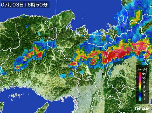
This is What Hit Us
All in all it was a harder ride than the much longer trip to Nagoya I did last month, but much more enjoyable for the same reason (more and better climbs), and also because the scenery was so much nicer this time.
All of this pales in comparison to what I plan for next week, which starts off with this 1,747m (5,730') climb. Weather permitting, I'll do it twice, once slowly with my Nikon D4 and a few nice lenses, and again the next day with friends and only my small cycling camera. We'll see.
Do you have a post talking about the technology you use on these longer rides? I know you are tracking on Strava, but do you use it on a mobile device with an external battery or?? That ‘This Road Again’ picture looks like a great shot for ‘Top Gear (for Bikes)’.
On long rides I generally record my track with an iPhone 6+ using the Wahoo Fitness app, and Galileo Offline Maps. I also record with a Bad Elf GPS+ standalone unit, and sometimes an old Garmin standalone unit. I have an external battery for the phone if I need it. —Jeffrey
Enjoyed seeing all the photos of your recent rides. The LX100 seems to be performing well. A question: how do you compose your shots while moving? Tom in SF
Tom, I use the same techniques to compose my shots while riding as while stationary: luck, and adjustment during post processing. 😉 —Jeffrey
Great pictures! And thanks for the offline map links. Very handy.