
iPhone 7 Plus — 1/40 sec, f/1.8, ISO 25 — map & image data — nearby photos
Starting in the Ocean
rear wheel in the Sea of Japan
city of Toyama, Toyama Prefecture, Japan
I recently did a bicycle ride that I'd been planning for months: to do Japan's biggest road climb, a single climb going from sea level to Japan's highest paved road at Mt. Norikura, at an elevation of 2,717m (8,914'). As far as I know, it's the biggest possible elevation gain in a single paved-road climb in Japan, and as far as I know, it's never been done, or even known of, until now.
I've ridden that “highest paved road in Japan” road before, as blogged about here, but this time I would start 110km (68mi) away at the ocean (elevation: 0), in the city of Toyama.
I'd spent months researching the most direct route from the ocean, updating road data (as described in “Updating Maps for Cycling, Including Japan’s Pseudo One-Way Roads”), refining my elevation database, and scoping out places to get food and drink along the way.
Here's the route that I came up with:
... and here's the elevation profile:
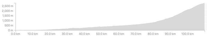
It's almost completely flat at the start, rising ever-so-gently from the ocean towards the mountains. It's one solid climb all the way from pretty much anywhere you start in Toyama; I found a boat launch that's paved into the ocean, so that seems to be a great place to start.

I'd gotten a hotel in Toyama, and was out the door by 5am to make the 20-minute ride up to the climb's starting spot in the ocean. I'd come the previous afternoon, after checking into the hotel, to make sure that it still existed (I'd done all my research with Google Maps and Google Earth).

iPhone 7 Plus — 1/30 sec, f/2.2, ISO 64 — map & image data — nearby photos
Ready To Roll
selfie just before starting out, with the rear tire in the ocean
I picked a simple path through the city, so as to make an easy-to-follow route in case others might want to do it.
I say it's “one unbroken climb”, but that's in the big-picture sense, and doesn't mean that every step forward actually goes up. (If that were the case, traversing a speed bump would break a climb into two.) There are times over the 110km that the roads dips down slightly, such as a short mild descent to meet a bridge that crosses a river, or to dip under train tracks:

For all practical purposes, though, it's one single climb, and so I was looking forward to have it under my belt.

The sun rose at 5:35, but didn't make an appearance until 6am. I thought it was lovely at the time, but it heralded a strong wind that materialized out of nowhere. I'd been feeling good until then, but then became consumed with worry that I'd have to contend with the wind for the next five hours, until I got to the steep stuff (for which a wind doesn't matter as much).
 away -- Toyama, Japan -- Copyright 2018 Jeffrey Friedl, https://regex.info/blog/")
iPhone 7 Plus — 1/120 sec, f/2.8, ISO 25 — map & image data — nearby photos
First Sight of the Goal
I think that's Mr. Norikura to the right of center, 65km (40 mi) away

iPhone 7 Plus — 1/125 sec, f/2.8, ISO 20 — map & image data — nearby photos
“Steep” Section Early On
The first 80km has only 800m of climb, so it averages a very mild 1%, though there are a few short sections at 5%. There's even one very short bit that goes down at 5%, but it's so short that it has no material impact on the overall climb.

iPhone 7 Plus — 1/60 sec, f/2.8, ISO 1250 — map & image data — nearby photos
Lots of Avalanche-Protection Half Tunnels
I felt good, other than the headwind and a slight bloating feeling. I was worried that I'd not have a lot of chances to refill on water during the ride into the mountains, so I was drinking a lot and refilling whenever I had the chance. I was also eating copious amounts, in addition to the big breakfast I'd had at the hotel, so as to avoid The Bonk (running out of energy) on the long ride. In this I was successful.
 -- Hida, Gifu, Japan -- Copyright 2018 Jeffrey Friedl, https://regex.info/blog/")
iPhone 7 Plus — 1/120 sec, f/2.8, ISO 20 — map & image data — nearby photos
Much Cooler than I Expected
22°C (68°F)

iPhone 7 Plus — 1/350 sec, f/2.8, ISO 20 — map & image data — nearby photos
Horrible Photo of a Gorgeous Scene
I wish I had my real camera

iPhone 7 Plus — 1/60 sec, f/2.8, ISO 1250 — map & image data — nearby photos
One of Several
long tunnels


iPhone 7 Plus — 1/610 sec, f/1.8, ISO 20 — map & image data — nearby photos
Free, Drinkable Water
I'm not sure why it was presented this way, but I was thankful for the water

Despite what one might think at first, that sign doesn't mean “12% grade for the next 6km”, but instead it means that there are sections that are up to 12% steepness at points during the next 6km. The average for the 6km is actually just 5%, so it's not that bad.

iPhone 7 Plus — 1/280 sec, f/2.8, ISO 20 — map & image data — nearby photos
Norikura Disappearing into the Mist
I thought it was pretty at the time. Little did I know...

iPhone 7 Plus — 1/240 sec, f/1.8, ISO 20 — map & image data — nearby photos
First Mention of “Norikura”
100km into my ride

iPhone 7 Plus — 1/250 sec, f/2.8, ISO 20 — map & image data — nearby photos
First Street Sign with “Norikura”

iPhone 7 Plus — 1/120 sec, f/2.8, ISO 20 — map & image data — nearby photos
Absolutely-Ridiculous Signage
I've written about the ridiculous way some Japanese road-restriction signs present themselves, such as in “No Motorcycles Allowed….. Sometimes… Sort of”, but the one above takes the cake.
Here's a literal translation of the various parts:
(Note that in Japanese traffic law, a bicycle
is a “vehicle” just like a car or truck or bus.)
May 15 through June 30
October 1 through October 31
6pm through the next day's 7am
July 1 through September 30
6pm through the next day's 3:30am
(busses, taxies, bicycles, special permission excepted)
May 15 through June 30
October 1 through October 31
7am through 6pm
July 1 through September 30
3:30am through 6pm
Norikura Skyline
What this is saying, in the most-convoluted way, is:
From July 1 through October 31, only buses, taxies, bicycles, and those with special permission are allowed, and only during the day (well, from 3:30 am in the middle of the summer).
The sign doesn't mention anything about other times of the year (fall, winter, and spring), but I know that the road is physically closed off with a gate, due to snow.
The takeaway from this is that normal passenger cars are completely prohibited at all times.
I don't understand why they need to present it in such a convoluted way. Everything is a restriction (including the “... excepted” part, which is a restriction on the restriction), which I suppose is fine, but why couldn't they say it simply?
I wonder how long it would take the average Japanese driver, when presented with these signs, to realize that they're telling him that he's not allowed to proceed?
Also odd is that the signs aren't about the road that they're on. For whatever reason, these signs were placed on the main road, but they talk about the road that turns off to the left. Very strange.
In any case, as a cyclist, I was allowed to take the road at that date and time, so I did. It was steep, but pretty.

iPhone 7 Plus — 1/120 sec, f/1.8, ISO 32 — map & image data — nearby photos
Deep Nature
very steep nature


That section of road was about 4km, and averaged 9.3%.
It brought me, finally, to the Norikura Skyline, the last 14km (8.5 mi) stretch to the top. Despite being only 13% of the distance, its 1,020m (3,350') of climb comprised more than a third of the entire trip's. It averages a 7.3% grade overall, but that belies the fact that not all sections are the same: the 2nd and 8th kilometers average 10%, and the kilometer after each of those averages 9%. On the other end of the scale, the 13th kilometer averages only 3.6%, bless its heart.
This final push to the top would be the most physically-demanding section, but having completed the long, mentally-demanding runup to here, with the goal in sight, I was feeling good.
That didn't last long.

iPhone 7 Plus — 1/160 sec, f/2.2, ISO 25 — map & image data — nearby photos
Denied
turned away because of “too much fog”
As I approached the guard/toll gate, a worker had come out and stood waiting to meet me with wrists crossed in an “X” sign, the universal sign in Japan for “no/closed/bad”. I knew immediately that my attempt at Japan's Biggest Climb was over, because I knew that in Japan when these kinds of decisions were made, they were completely non-negotiable.

iPhone 7 Plus — 1/1400 sec, f/1.8, ISO 20 — map & image data — nearby photos
List of Road-Closure Conditions
none of which were triggered, except for the vague “snow/ice/fog” at the bottom
The “too much fog” reason is just so stupid. I can certainly take responsibility for myself, and as for others, the road is always closed to normal traffic, so the only vehicles allowed are the occasional taxi or bus driven by professionals. (As you can see in the photo above, the toll for a large bus is 10,200 yen, about US$100!) I had bright flashing lights both front and back, and the fog, however thick it was, would have been only at the very top anyway. It was just stupid.
It seems that I should have checked The Skyline's home page to see the current status, I learned from the guard. As of this writing, the road is open to cyclists, as evidenced by the marked circle:
When I was turned away, it was an “⨉”, and had been so from the previous day.
Now I know.
Overall, I spent half an hour there, at first trying to talk my way in, and then in figuring out what I'd do going forward. The main guy I talked to (not the one in the photo above) was full of empathy and easy to talk to, so that made things better, but it was still so very disappointing. I turned around to return to the hotel.
I eventually headed down a different way than I'd come up, via a lovely descent. But after having ridden more than 100km up hill, any descent would have been lovely.
The road eventually flattened out, and in the flatter areas the headwind had returned. Since three hours had been cut from my trip by the Norikura Skyline guard, I had plenty of time and was in no rush, so I took it easy, as I had been all day.
50km (32mi) into my return, I had a momentary worry about another road closure:

iPhone 7 Plus — 1/1000 sec, f/1.8, ISO 20 — map & image data — nearby photos
“Road Closed”
“Route 360 toward such-and-such a Pass”
I'd had two routes worked out for my return, one that was easy and one that looked to be very, very hard. On the return I'd been toying with the idea to try the hard one, but on paper it seemed almost as hard as the Mt. Fuji climb I'd done two months prior, which was both mentally and physically very difficult for me, so I'd decided that I just wasn't up to trying it. But now with this huge “Road Closed” sign, I worried that I'd have to do it.
I came across some road workers and asked whether the easy road to Toyama was closed. “No idea”. A bit farther on, I came across some surveyors and asked the same, and was cheerily told that it was open and without hills all the way. That sounded good.

This road, which was bypassed by a modern tunnel, looked much more appealing in Google Street View photos from four years ago:
As it was, I had to pick my way between the overgrowth, and among many fallen rocks and branches, but it was still nice.
The next 25km (17mi) were mostly downhill, and I seemed to have a tailwind because at times my speed was more than I could otherwise explain. It was nice.

iPhone 7 Plus — 1/240 sec, f/2.8, ISO 20 — map & image data — nearby photos
Pretty View
but again, the iPhone photos just don't do it justice
 -- Toyama, Japan -- Copyright 2018 Jeffrey Friedl, https://regex.info/blog/")
iPhone 7 Plus — 1/32000 sec, f/1.8, ISO 25 — map & image data — nearby photos
Rice Fields at the Edge of the City
taken at 32 kph (20 mph)
I arrived back at the hotel 10 minutes shy of a 12-hour ride. I'd ridden 215km (134mi) and climbed only 2,177m (7,150'). If I'd had done the complete climb, and the harder return, the climb would have been about double, and my biggest ride in that respect. As it was, the amount of climb was nothing special (it's ranked #39 in my rides by climb). By distance, it's my #6-longest ride.
I brought my scale along to weigh myself before and after. During the ride I had 9,075ml of drink (2.4 gallons) which in itself weighs 9kg (20lb), and in addition ate in abundance, but I still lost 3.8kg (8.4lb) during the 12-hour ride. This did involve one bathroom break, but the bulk of the loss was 28 pounds worth of sweat. Wow.
Here's the ride at Strava:
And here's the Relive video of it:
Relive 'My Super Disappointing Ride of Crushing Disappointment / がっかりばかりのライド'
My hotel was a nice business-budget hotel near the train station, and as such the restaurant was more “cafeteria” than “restaurant”, but I was happy for real food.
 -- APA Hotel (アパホテル) -- Toyama, Japan -- Copyright 2018 Jeffrey Friedl, https://regex.info/blog/")
I had a couple of beers in my room fridge waiting for me, but I ended up just passing out, and sleeping well. I checked out early, and made the 4-hour drive home.
Ah, but even had you made it to the top of the mountain, this ride wouldn’t have counted. When your bike tire was in the Sea of Japan, it was high tide. To REALLY get from lowest to highest, you’d have had to start out at low tide – ~5 hours later.
See, aren’t you GLAD you didn’t waste all that extra time/effort?
Great ride except for the disappointment of not getting to the top.
I’m sure you’ll be back one day, and complete the climb. Then it will taste even better !
Please never stop explaining funny road signs 🙂
Thank God you weren’t out there when the typhoon hit. Hope you and your family were tucked in safely at home. when you and your friends ventured out the next day to survey the damage, weren’t you afraid of downed power lines?
I was out just before/after the typhoon, in some fun wild wind and rain. That’ll be a blog post later. As will when I went out the next day to survey the incredible damage. I was not worried about downed power lines because I’m sure the power was off, but still I made sure to stay well away from any exposed wire (of which I saw only one little bit at a wire-splice point). All other wires were clad in rubber. —Jeffrey
Recently discovered your blog. Not a cyclist myself but enjoy your photo journeys. Pictures of Kyoto are wonderful. Love the city. I will be there in mid-November. Was there much damage in the city and surrounding gardens from typhoon? Keep posting those great photos.
I don’t have the impression that there was a lot of widespread damage to gardens, no. —Jeffrey