It's been a long week as my boy had surgery to repair a broken finger (all appears to have gone well), so I'll try to get back in the groove with a rambling post on a flash flood in Kyoto last weekend. There were about two hours of intense rain in the middle of the night...
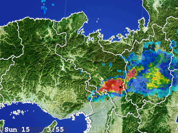
Intense Rain
Kyoto is the black dot to the lower-right of center
A couple of hours later, the accumulated water had washed down through the mountains to Kyoto...
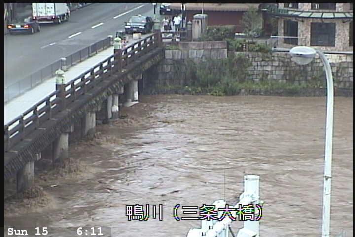
Quite a Bit Higher Than Normal
prefectural water-control camera on the Kamo River at the Sanjo Bridge
To give an idea for how much water is rushing by, this is the same bridge seen in this photo from an earlier post:

Nikon D700 + Voigtländer 125mm f/2.5 — 1/400 sec, f/2.5, ISO 280 — map & image data — nearby photos
Low Water
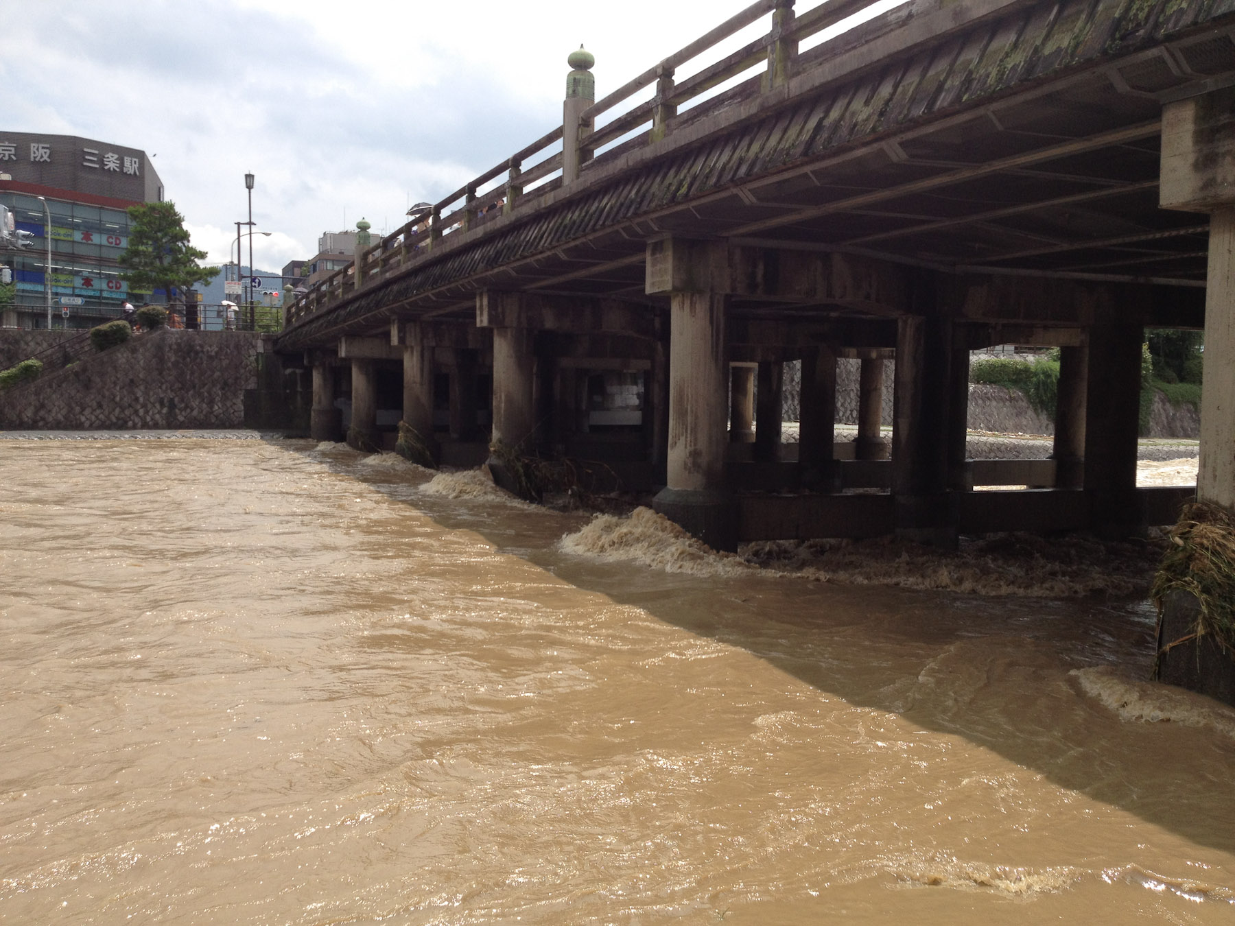
The elevation descends fairly quickly as the river flows from north to south, so the water is positively rushing by at breakneck speed. This quick flow generally clears things out quickly, but 3½ inches/hour of rain for a couple of hours will fill things up quickly.

iPhone 4S at an effective 35mm — 1/2800 sec, f/2.4, ISO 64 — map & image data — nearby photos
Pretty Zippy Flow
a few hours after the peak
I had this same area on my blog for the same reason two years ago, in “Kyoto Kamo River Flooding: Sanjo”. This time I didn't know about it until after the fact, but this one seems to have been worse.

iPhone 4S at an effective 35mm — 1/2800 sec, f/2.4, ISO 64 — map & image data — nearby photos
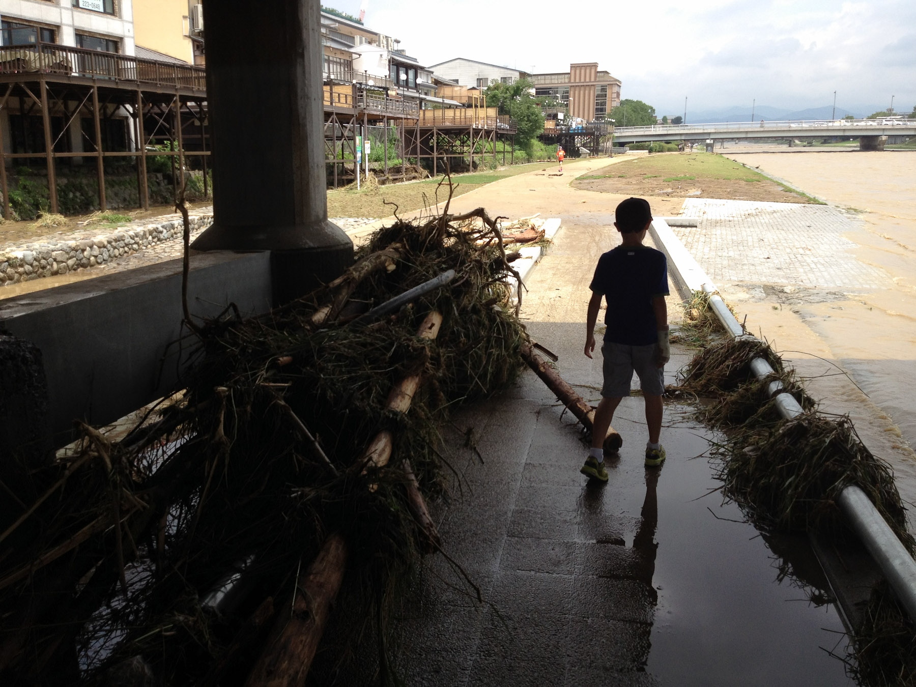
Remnants
The monument thing in the foreground had an engraved faceplate ripped off by the current. I happen to have snapped a shot of the area a few days earlier, where you can see a couple of people sitting in front of the monument to the far right of the frame...
 -- Kyoto, Japan -- Copyright 2012 Jeffrey Friedl, https://regex.info/blog/")
Nikon D4 + Nikkor 85mm f/1.4 — 1/80 sec, f/1.4, ISO 11400 — map & image data — nearby photos
Earlier
(You can also see it, still intact, during the previous flood here).
If you ever visit Kyoto and walk along the nice paths on either side of the river, you'll see these monument things every so often, with maps showing where you can enter/exit the paths. For reference, I happened to have some snapshots of other markers at other times...


I walked along the river for quite a distance during the walk that produced “Informal GPS Logger Test: iPhone 4s GPS is Shockingly Good”, when I also snapped those two shots above.
Anyway, the rapid rise and fall left quite a bit of debris...


iPhone 4S at an effective 35mm — 1/2500 sec, f/2.4, ISO 64 — map & image data — nearby photos
Newly-Laid Sod
this area just had sod laid earlier this month
 -- Kyoto, Japan -- Copyright 2012 Jeffrey Friedl, https://regex.info/blog/")
Nikon D4 + Nikkor 85mm f/1.4 — 1/80 sec, f/1.4, ISO 10000 — map & image data — nearby photos
A Few Days Earlier
One thing Japan Inc. has never figured out is how to make a nice lawn, so the flood merely hastened what would naturally happen. The brown area beyond the newly-laid sod in the photo above was new itself about a year or so ago (you can see it on this post) and is already a total loss. I don't know why they ever bother. But I noticed someone placing cones when I went by yesterday, so I suppose they'll give it another try.
This “flooding” is nothing compared to what was happening in south-west Japan during the same period, with mudslides and lots of deaths, but the same rain would have been much worse here in years past. Sometime in the mid 1900s the river was drastically widened and deepened, creating a man-made flood-control channel.
 -- Kyoto, Japan -- Copyright 2012 Jeffrey Friedl, https://regex.info/blog/")
Nikon D700 + Nikkor 300mm f/2 — 1/3200 sec, f/2, ISO 200 — map & image data — nearby photos
Sculpted
a bit up river, taken on my Kyoto Marathon outing in March
Prior to that the shallow river would flood regularly, causing havoc for the folks who lived in the otherwise-prime real-estate. They were probably prepared for the common flood like this, but one would suppose that a bigger flood every 10 or 20 years, especially in the middle of the night like this one, would be a real disaster.