
Good Satellite Tracking
with three different units, as I rode along the south edge of this road
Over the years I've reported on informal tests with satellite-tracking location-logger units (“GPS trackers”), such as “More GPS Cycling Tests” from three years ago, and from six years ago, “Another Informal Location-Logger Test” (itself a followup to “iPhone 4s GPS is Shockingly Good”).
When cycling, I try to record my ride on at least three different units, because they tend to fail in the middle of a ride a lot more commonly than one should think, and the data geek in me doesn't want to risk losing data on the ride. I've recorded every one of the 23,827 kilometers I've ridden since getting into “real” cycling a few years ago, and I love every bit of it. (Hahah, “bit”... “data”.... see what I did there? 😀 )
Finally getting my bike fixed (after my frame bit the dust in March), I was able to do my first proper ride in ages the other day (at Strava):
Along on the ride I had three units to track my location:

On The Climb To Rokucho Pass
blue is an iPhone 7
orange is a Garmin Edge 820 cycling computer
green is a Polar M460 cycling computer
Satellite reception tends to be pretty bad during that climb, so the minor drift seen above is pretty good for all three of them. The blue iPhone track is the most accurate by far, though.


Not So Good
but still totally usable

Perfect Again
in a flat area

What!?
Suddenly the Garmin Edge 820 is more than a mile off track
Just after I got to the river at the left side of the screenshot, the Garmin's location lock started to drift, and for 3½ minutes it was merely “pretty bad”, but then suddenly it started marching off on a steady, mostly-straight line across the map, like a drunken member of a strolling group who suddenly sees a late-night pancake house and determinedly, though slightly wobbly, homes in on his target, much to the consternation of the others.
After 3½ minutes of that wildly-off-course single-minded deviation, it must have gotten its pancakes, because it stopped updating for two minutes, and then was suddenly back in the general vicinity of correct. After another minute or so of trying to stand without falling over — 10½ minutes after it went totally crazy — it's back in perfect step with reality.
I've seen a lot of bad tracking in the decades that I've been paying attention to this stuff, but nothing even remotely this bad for so long. Just crazy.
The Garmin's tracking was just dandy for the next seven minutes, but then it went bat-shit crazy for the next hour and a half....

An Hour and a Half's Insanity

Whaaaaaaaaat!??
And so after almost two hours of this craziness, it fixed itself and was fine for the rest of the trip.
Really weird.
In any case, I was able to use the tracklog from my phone, recorded with
Galileo Offline Maps (Name changed Feb 2019 to Guru Maps),
and so my ride data was saved.
The ride itself was lovely.
For the first two climbs, I consulted with Jason Eisenmenger (seen here) on a kind of power training, where I pick a power level, and try to stick to it for the whole duration, watching the readout from my power-meter pedals, adjusting my effort to try to keep it consistent.
For the first short climb (about 4 minutes at 10%), I thought I'd try to keep an average of 300w, but it turned out to be too steep to use that little power, and I ended up averaging 385w.
My time of 4:03 was much slower than my all-time best of 3:14. In order to equal that best time again, I'd have to average 482w, which I doubt I could do, but if I were to shed 10kg of fat, I'd have to average only about 440w, which would be plausible.
The second climb was much longer, 7.6km @ 5%. For this I aimed to keep a 280w average, and ended up at 287w for the 32:14 it took.
To equal my best-ever time of 27:38, I'd need to maintain 335w, but if I dropped that 10kg, I'd need only 300w, which again is plausible.
So, hopefully getting back into a habit of rides will both increase my fitness and decrease my weight.
After those climbs, I put the power meter away, and just enjoyed the mountains. My goal for the day was to investigate some of the minor roads around Hiyoshi Dam.

iPhone 7 Plus + iPhone 7 Plus back camera 6.6mm f/2.8 at an effective 57mm — 1/350 sec, f/2.8, ISO 20 — map & image data — nearby photos
Arriving at the Lake
made by Hiyoshi Dam
There's a long, lovely descent just before arriving here. I first did it two years ago (mentioned on this post), and have now done it many times.
That first time I'd taken it carefully, averaging 65kph (40mph) for the 2:05 it took to find the bottom. Over the next few attempts, I really gave it my all and tried to finish as quickly as possible, and every time I ended up with exactly the same time. It was frustrating.... I just couldn't break that two-minute-five-seconds barrier.
This time, though, I had no intention to try to hard, being so out of shape and out of practice. It's been a long time since I've had my downhill mojo, so I didn't push hard and just had fun. And, of course, I beat my record by one second. 🙂
I didn't have a real camera — only my iPhone — but I've posted photos from this area many times over the years. (Also see my map of blog photos centered on the lake.)

iPhone 7 Plus + iPhone 7 Plus back camera 3.99mm f/1.8 at an effective 28mm — 1/260 sec, f/1.8, ISO 20 — map & image data — nearby photos
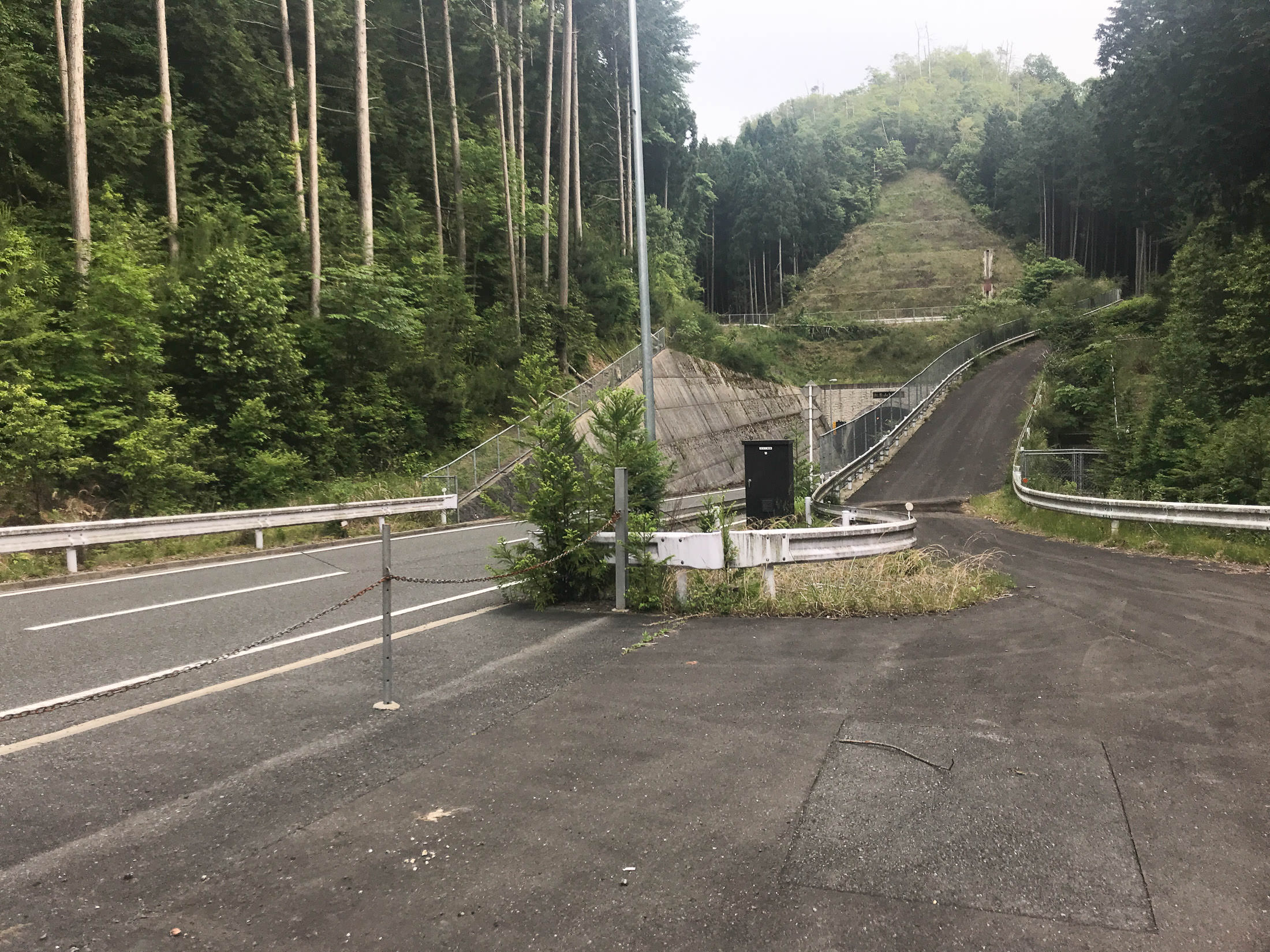
One of the roads I explored ended up at a possibly-abandoned dirt race track:

iPhone 7 Plus + iPhone 7 Plus back camera 3.99mm f/1.8 at an effective 28mm — 1/1400 sec, f/1.8, ISO 20 — map & image data — nearby photos
Sad Little Area

iPhone 7 Plus + iPhone 7 Plus back camera 3.99mm f/1.8 at an effective 28mm — 1/390 sec, f/1.8, ISO 20 — map & image data — nearby photos
Local Logging
One road I explored ended up diving into the lake, as an apparently-little-used slipway:

iPhone 7 Plus + iPhone 7 Plus back camera 3.99mm f/1.8 at an effective 28mm — 1/690 sec, f/1.8, ISO 20 — map & image data — nearby photos

iPhone 7 Plus + iPhone 7 Plus back camera 3.99mm f/1.8 at an effective 28mm — 1/1000 sec, f/1.8, ISO 20 — map & image data — nearby photos
Steep Return Trip

iPhone 7 Plus + iPhone 7 Plus back camera 3.99mm f/1.8 at an effective 28mm — 1/240 sec, f/1.8, ISO 20 — map & image data — nearby photos
For Bears
who don't want to poop in the woods

iPhone 7 Plus + iPhone 7 Plus back camera 3.99mm f/1.8 at an effective 28mm — 1/120 sec, f/1.8, ISO 25 — map & image data — nearby photos
Not a Paved Residential Road
Most of the roads I checked out had been marked on OpenStreetMap as paved residential roads, which seemed highly unlikely, but before fixing that data I thought that I should check to be sure, so I did. The one above was gravel, but fine on a road bike.
 -- Nantan, Kyoto, Japan -- Copyright 2018 Jeffrey Friedl, https://regex.info/blog/")
iPhone 7 Plus + iPhone 7 Plus back camera 3.99mm f/1.8 at an effective 28mm — 1/900 sec, f/1.8, ISO 20 — map & image data — nearby photos
Pausing at Vending Machines
so I propped the phone up and used the timer to take a photo

iPhone 7 Plus + iPhone 7 Plus back camera 3.99mm f/1.8 at an effective 28mm — 1/280 sec, f/1.8, ISO 20 — map & image data — nearby photos
Another Slipway

iPhone 7 Plus + iPhone 7 Plus back camera 3.99mm f/1.8 at an effective 28mm — 1/800 sec, f/1.8, ISO 20 — map & image data — nearby photos
This One In Active Use

iPhone 7 Plus + iPhone 7 Plus back camera 3.99mm f/1.8 at an effective 28mm — 1/60 sec, f/1.8, ISO 25 — map & image data — nearby photos
Most of the Road is Gone
It's a bit difficult to see in the photo above, because I took it right from the edge of the road that remained, but much of the “road” that had been there had fallen into the ravine. I put “road” in quotes because it was very rough, overgrown gravel. Even if the road hadn't disappeared, I probably would have turned around soon.
There was a parallel road on the other side of the steep ravine, and that was in much better shape...

iPhone 7 Plus + iPhone 7 Plus back camera 3.99mm f/1.8 at an effective 28mm — 1/120 sec, f/1.8, ISO 32 — map & image data — nearby photos
View of the Fallen Road
from across the ravine
But it, too, became more and more rough as I got deeper into the mountains...

iPhone 7 Plus + iPhone 7 Plus back camera 3.99mm f/1.8 at an effective 28mm — 1/30 sec, f/1.8, ISO 32 — map & image data — nearby photos

iPhone 7 Plus + iPhone 7 Plus back camera 3.99mm f/1.8 at an effective 28mm — 1/25 sec, f/1.8, ISO 40 — map & image data — nearby photos
Big Mud Puddle
this is where I called it quits on this road, and turned around

iPhone 7 Plus + iPhone 7 Plus back camera 3.99mm f/1.8 at an effective 28mm — 1/125 sec, f/1.8, ISO 20 — map & image data — nearby photos
Looks More Promising

iPhone 7 Plus + iPhone 7 Plus back camera 3.99mm f/1.8 at an effective 28mm — 1/60 sec, f/1.8, ISO 25 — map & image data — nearby photos
Beautiful
very-well paved, but covered in a deep layer of detritus
iPhone 7 Plus + iPhone 7 Plus back camera 3.99mm f/1.8 at an effective 28mm — 1/730 sec, f/1.8, ISO 20 — map & image data — nearby photos
End of the Lovely Road
it joins to a new, modern road that dives into a tunnel,
but also there seems to be a road up over the tunnel....

iPhone 7 Plus + iPhone 7 Plus back camera 3.99mm f/1.8 at an effective 28mm — 1/900 sec, f/1.8, ISO 20 — map & image data — nearby photos
Above the Tunnel

iPhone 7 Plus + iPhone 7 Plus back camera 3.99mm f/1.8 at an effective 28mm — 1/400 sec, f/1.8, ISO 20 — map & image data — nearby photos
Oops, But It Doesn't Go Anywhere

iPhone 7 Plus + iPhone 7 Plus back camera 3.99mm f/1.8 at an effective 28mm — 1/730 sec, f/1.8, ISO 20 — map & image data — nearby photos
This Offshoot Seems To Go Somewhere
but it's way too steep and cluttered for me to try now
I then took the tunnel, which descends steeply toward the city of Kameoka. After exiting the tunnel is this lovely, steep descent. The fastest time averages 70kph over the whole 1.75km distance, which is too fast for me to take some of the curves it has.

iPhone 7 Plus + iPhone 7 Plus back camera 3.99mm f/1.8 at an effective 28mm — 1/4000 sec, f/1.8, ISO 20 — map & image data — nearby photos
Newly-Planted Rice
lots of this in Kameoka
My final surprise for the ride was that I made a new personal record (PR) for the climb up the mountain that separates Kameoka from Kyoto. This shocks me even more than the aforementioned descent PR did, as I wasn't even trying to have fun, or anything, with this one... just plodding along, trying to get my fat gut back home. But, as I found out when I got home, I beat my previous best by 23 seconds.
Anyway, it was lovely to be back on the road. I hope my Garmin Edge 820 has its sanity back for good. We'll see.
Just out of curiosity – what was the distance traveled as measured by the garmin vs the iPhone?
The final iPhone track calculates out to 115,027m (71.47mi), while the Garmin comes out to 131,624m (81.79mi). The Polar’s track came to 113,349m (70.43mi). —Jeffy
Do you know if the sampling rates of the various GPS units are the same? Garmin has about a 1Hz rate, right? Is the phone faster? And is the phone getting AGPS or whatever cell-tower assistance is called?
I’ve seen some units that let you choose up to 10Hz, but 1Hz seems to be the most common, and all three of my units gave me 1Hz logs. (Software may reduce/filter that further to save space or throw out suddenly-unlikely data points, but I tend to turn that off.) There are various different ways that “GPS” is augmented, and all three units also use GLONASS (the Russian version of GPS), and the Japanese version of WAAS, MSAS. The phone and the Polar unit also use extra GPS-like Japanese-specific Michibiki satellites. (The Garmin unit could use them, but doesn’t, because, I suppose, Garmin wants people to buy the more-expensive Japan-market version of the unit.) I don’t know whether the phone uses cell-tower stuff, or even how much that might help if it did. —Jeffrey
I’m curious about this three device strategy. Are you recording heart rate as well? If yes, do you use two HR straps or one which can broadcast both ANT+ and Bluetooth LE? Or skip HR altogether?
My power meters and HR straps both broadcast on both ANT+ (to the Garmin unit) and Bluetooth (to apps on my phone). If the track that I actually intend to upload to Strava doesn’t happen to have some set of data, I just pull it in from the other tracks… even if their location data is totally wonky, the association between time and the various extra data (power/HR/cadence/speed) is exact, so I always end up with accurate data. Regardless of what track I use, I also replace its elevation data by snapping the route to known elevations at known points (from highly-accurate government laser-ranged data). My tracklogs get a lot of processing before upload, to ensure their adherence to reality as best I can. —Jeffrey
Have you checked to see if the three devices are interfering with each other at times?
They’re GPS antennas… they don’t produce signals that might interfere with GPS reception. —Jeffrey
Further to my earlier text, another possibility would be external radio frequency interference from sources located along your route.