I'm ostensibly spending the summer here in The States for Anthony's English development, but the real reason is to load up on camera toys. I do get things in Japan, but I prefer to buy some things here because of price, availability, ease, or just mental comfort.
It's been a while since I treated myself to some nice camera toys, so I've developed quite a list of fun toys to procure on this trip.
This post is about the GPS unit I got a few days ago, a Garmin eTrex Legend HCx, as a replacement for my Garmin GPSmap 60CS (which I wrote about when I got it last year). I consider it a camera toy because I geoencode most of my photos (as mentioned here).
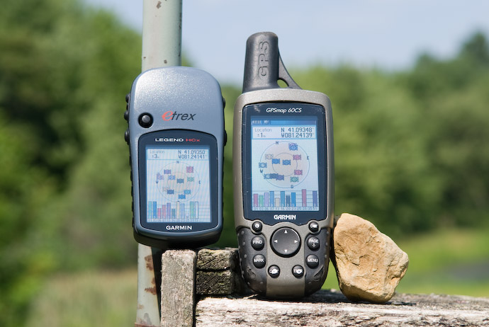
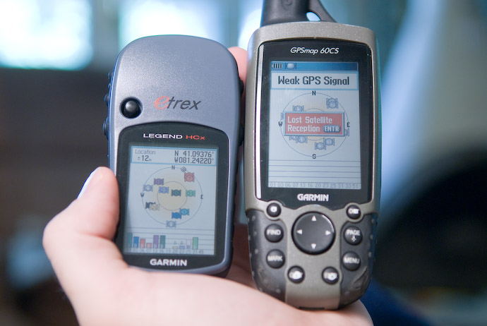
Here they are together, sitting on an old birdhouse in the back yard, the small new one on the left....
Nikon D200 + Nikkor 17-55 f/2.8 @ 55mm — 1/320 sec, f/5.6, ISO 100 — map & image data — nearby photos
eTrex HCx and GPSmap 60CS
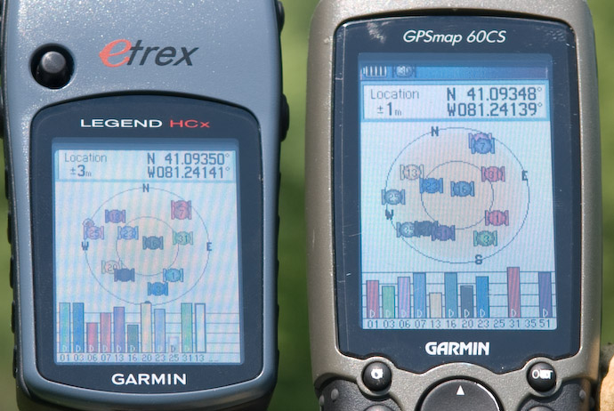
Garmin's eTrex line are conveniently smaller than what I had, but that also means a smaller screen and smaller antenna. Because of the latter, I shouldn't have been surprised to find the old one was more accurate. Compare the accuracy of ±1 meter for the old one, to ±3 meters for the eTrex....
Nikon D200 + Nikkor 17-55 f/2.8 @ 55mm — 1/320 sec, f/5.6, ISO 100 — map & image data — nearby photos
Nikon D200 + Nikkor 17-55 f/2.8 @ 17mm — 1/160 sec, f/8, ISO 100 — map & image data — nearby photos
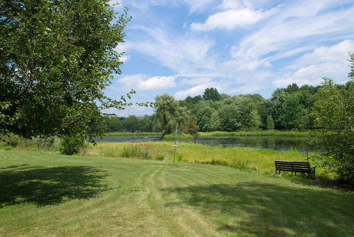
Wide Open Area
Garmin packs a lot of meaning into its names. In the name “eTrex Legend HCx”, the “H” indicates that it has the latest generation high-sensitivity antenna, the “C” indicates a color screen, and the “x” indicates that it accepts removable media (in this case, a MicroSD card).
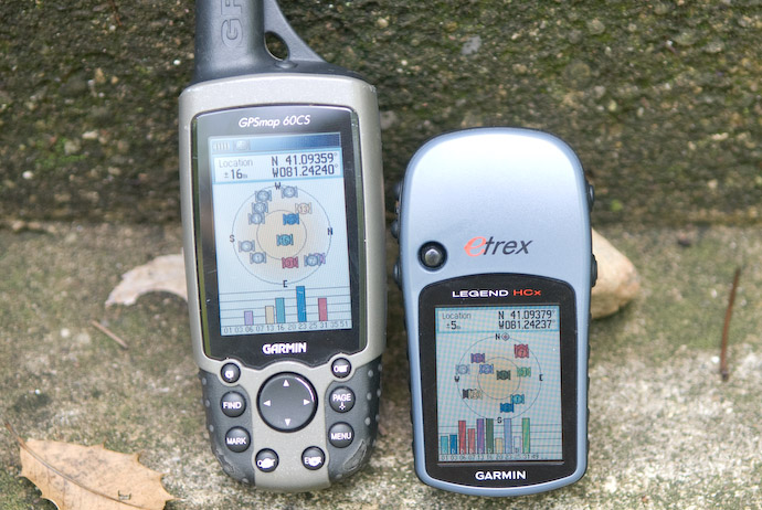
The high-sensitivity antenna is a huge win when you don't have a clear view of a wide area of sky (under trees, near buildings, inside houses), which is the primary reason I bought the new one. Even though it's less accurate in the situation above, look how it compares under the trees near the front door of the house:
Nikon D200 + Nikkor 17-55 f/2.8 @ 45mm — 1/90 sec, f/2.8, ISO 400 — map & image data — nearby photos
Outside the Front Door, Under Trees
Even better, the new one gets a signal inside the house, while the other one has no chance....
Nikon D200 + Nikkor 17-55 f/2.8 @ 44mm — 1/40 sec, f/2.8, ISO 400 — map & image data — nearby photos
Inside the House
Garmin just released two new eTrex HCx units, the Legend that I'm writing about today, and the Vista, which adds an electronic compass and a barometric altimeter. My old unit also has these extra features, and while I really liked the electronic compass, it wasn't worth the pain of having to put up with the barometric altimeter, which is entirely worthless, producing results that differ only slightly from random. So, I avoided it for this purchase.
Anyway, my old unit and my new one are my only experience with handheld GPS, so I don't have much to compare them against except each other. In case others are interested in the eTrex HCx series, I thought I'd offer my first impressions....
Garmin eTrex Legend HCx
Here are some first impressions of the eTrex Legend HCx...
It comes with a small lanyard, but no belt clip. I can use the big bulky belt clip that came with my 60CS, but that almost doubles the thickness of the thing. Is there no thin, non-bulky belt clip for Garmin units?
It accepts a MicroSD card, but does not come with one. I bought a Transcend 1 GB MicroSD card from Adorama for twelve bucks. The unit can save track logs to the card, which I can then use for geoencoding my photos.
In my prior unit, I was limited to the 10,000 point internal memory. That's less than three hours when saving a track point every second, or about 14 hours when saving every five seconds, so I had to be careful not to fill it up on extended trips. With the 1 GB card, I figure that I can have it save a point every second for more than a year, so I no longer need to worry about track-log space at all.
The eTrex has only six buttons, compared to the nine of the 60CS, and the layout is completely different, so I had to relearn the buttons from scratch. Some functionality that I was used to on the 60CS seems to be completely lost on the eTrex, such as the ability to flip among the screen pages in reverse. The “enter” button, which is a dedicated button on the 60CS, is now part of a four-point rocker button, and I find that I often press it as a rocker when I intend to press straight in for “enter.” Maybe I'll get used to it...
The eTrex is clearly designed to be used while being held in the left hand. The 60CS seems fairly ambidextrous to me.
The screen on the eTrex is smaller. I miss having the battery-strength indication always there at the top (on the eTrex, you have to hit a button to see it), but otherwise the smaller screen has not been an issue for me.
As mentioned earlier, the antenna is more sensitive. It can get a signal in many places that the 60CS can't, and do so faster. In my tests, the 60CS gets its first fix in about 45 seconds after being turned on, while the eTrex HCx takes about 31 seconds. However, if the eTrex is “hot” (which means that it's had a signal at any time within about the last 15 minutes), it re-fixes immediately, which is nice. (I've got a note into Garmin asking exactly what “hot” means for this unit.)
Once the eTrex gets a fix, it automatically switches to the map view. This really bothered me because I generally prefer to see the satellite view (which is what the 60CS does), but I figured out that if you adjust the settings such that the satellite page is at the top of the list of pages to be shown, it won't automatically switch.
The 60CS has writing on the buttons that's been rubbing off. The eTrex won't have this problem because it has no writing on its buttons.
Both units support WAAS for added accuracy, but it keeps getting disabled in the new eTrex unit. I asked Garmin about it, and they said that a firmware update was being worked on.
My unit arrived with a bad pixel on the screen, but it's really noticeable only during the power-on screens.
Speaking of the power-on screens, Garmin allows you to create a message that's displayed when the unit is turned on, and I've put my name and phone numbers on mine. With the 60CS, the message is displayed for eight seconds, which is long enough at least for someone to recognize that it's the owner's contact info.
The eTrex unit, on the other hand, shows it for only two seconds, which is not really long enough to even notice. The eTrex unit does show a couple of “Garmin” and copyright screens during startup, so if they combined them like they do with the 60CS, they could show all of it longer without lengthening the overall startup time. As it is, the personalized startup screen is essentially meaningless on the eTrex.
I was surprised to find that the date/time shown by the units sometimes differed between them by as much as 1.5 seconds. The time is supposed to be kept exceedingly accurate, updated continuously from the satellites, but according to Garmin, this can sometimes get “stuck.” They told me that auto-locating the unit can reset this. (“Auto-location” is done when the unit is first turned on after purchase, and when it's turned on more than 600 miles from where it was last used.)
Overall I'm happy with the eTrex Legend HCx, and if I can find a reasonable belt clip or other way to attach it to my camera bag, I'd be even more happy.
The WAAS issue is interesting. I’d expect that with working WAAS support, you’d see almost identical accuracy on both units.
Actually, WAAS was working when I took the top photos (as evidenced by the “D” on each satellite-strength bar; I take it that “D” stands for “differential,” but I’m not sure). The problem with WAAS on the new unit is that it auto-disables, but hopefully, the new firmware should fix that. Interestingly, though, the 1-meter accuracy on the old one was the best I’d ever seen, the previous best having been 3 meters. It’s more often about 5 meters out and about in Kyoto, so in a practical sense, the new one will likely be more accurate in places I most-often use it, so I’m not disappointed or anything. —Jeffrey
I’ve been pretty pleased with my ancient GPSMAP 76S with the updated firmware for WAAS.
Thanks for doing the review! I was looking at getting either the Garmin GPSmap 60CSx or the Garmin Etrex Vista Hcx. There is a $50 US rebate for the 60CSX, so that is one of the main reasons the 60CSX is being considered. After reading through your review and a number of other reviews, I am convinced that the Vista HCx is the better of the two. Price-wise, the 60CSX would have been approximatly $60 more than the vista hcx (the price difference takes into account the $50 rebate).
Oh yeah, the WAAS feature is also disabled on the Vista HCX when it is powered on/off – hopefully, they’ll get this fixed soon. Also, I don’t like the fact that the unit doesn’t “remember” any of my settings. For example, if I power the unit off/on, it doesn’t remember how I had set the backlight.
I’ve been enjoying your blog and adventures in buying camera toys!
I am interested what your work-flow for geo-tagging photos is and if you have found or created tools for easily extracting the data from your GPS, matching the time up with when your pictures were taken and then automatically adding the geo-tags to your pictures.
I’m surprised that they can’t keep time. That’s pretty goofy. The explanation of having to auto-locate is just weird. If it’s 3 seconds off then the location should also be thousands of miles off.
I have a GPS Time Server in my office at home. To say it doesn’t have that problem would be an understatement. 🙂 My wife tells me that it doesn’t help me be on time though.
– ask
Hi
Yesterday I updated my Legend HCx to the new software version 2.40.
I find that as a result of doing a direct update (not using updater) that
it has played havoc with my unit.
1. I can no longer acquire satellites even though I have tried using “New
Location” and setting it outside for 15 mins in direct view of satellites.
2. The date is shown as the 28th September 2007.
3. The time shown is 15.36 – time I did the update.
In short I am unable to use my unit as a result of doing this update.
Does anyone have any idea how to try to deal with this situation?
Also would a “hard start” help and if so how do I do a “hard start”?
Thanks for any help offered.
Regards,
Gerald
I’m either confused (likely) or not reading your review correctly. It seems like the 60cs is better in most comparisons that you point out!
It’s better in the two “super clear view of the sky” views of the same location, likely because the WAAS wasn’t working on the smaller unit (they’ve since pushed a new firmware that fixes it). Prior to that afternoon, I’d never seen better than 3m accuracy, so I was thrilled to see “1m” pop up. However, the next two photos — under tree cover, and inside the house — the new unit was substantially better/
If the only reason to switch is the external card, I can understand. I have a 60c (which I love) but it does have a limit on track points. Typically, however, I’m not out long enough to use them all up, so it’s really a moot point for me.
The extra track points was the big draw for me. The smaller physical size of the unit, greater accuracy, lack of barometric altimeter, and faster restart time are all just nice bonuses. —Jeffrey
I too have the HCx and really like it. Question: I have a 64mb card installed. When I’m shooting all day, I save my track at the end then use Houdah Geo to geotag the photos. Recently I was shooting for 3 long days before downloading/geotagging, and noticed that my “saved tracks” for each day only had 500 points and some of the earlier photos were geotagged incorrectly, where the data got cut off (even though I could still see the whole track on my GPS, and am positive I was getting a good track all day). However, I found the complete tracks on the internal memory card, automatically saved there as I’d set “log tracks to data card” in the data card/track log setup when I got the GPS. Each day a new file is created, it seems. But the only way I could get at these tracks was to insert the card into an external reader, find the date/GPX file I wanted, and import that file into Houdah Geo. This worked fine, but was less efficient. I’m wondering if you use a similar procedure, or is there a way to get directly to the larger track data files on the internal card, without removing the card (that is one SMALL card!)
Thanks for the help! Paul
Has anyone use the Garmin eTrex Vista HCx to link with any of the Nikon D200/300 or D3? I am wondering how to connect it to my cameras?
Nikon uses a serial interface with a proprietary conector, so even if it’s possible to hook up to a GPS unit’s USB connector, it would require a hodgepodge of cables (USB-to-serial, and serial-to-Nikon, the latter of which is extremely expensive). Given this situation and how clumsy I imagine it would be to actually shoot that way, I’m more than happy to continue geo-encoding from the tracklog after the fact. —Jeffrey
Thanks for your quick respond.
I am aware of the Serial (male) on the MC-35 and USB on the Garmin. I wonder if there is any wiring diagram for pins assignment to these connectors. Sure don’t mind making a connector myself, with the diagram I know we can make it work.
I have been reading about the di-GPS and the DP-GPS (and others) with the 10-pin connector, however, I was hoping to connect the camera to a GPS with a compass direction.
A colleague and I are planning to ‘home-made’ this connector. I will keep you up-to-date on the progress and findings.
It’s been done plenty of times before, so I’m sure you’ll be able to find the specs. Search on DPReview’s forums and you’ll find all kinds of stories about those who have been down this path (often with great success). —Jeffrey
Hi Jeffrey,
I’m thinking about picking up some sort of GPS device before my wife and I fly back to Scotland for Christmas. Any advice? It sounds like you bought yours in the US, but do you have any idea about buying them in Japan? I don’t really know anything much about GPS, but I’m fascinated by the whole idea and I’d love to try it out.
If you want to geoencode your photos the way I do (via syncing photos to a tracklog), then the important point is how big a tracklog the device can keep. Those that accept a memory card are best because they’re limited by the size of the card (which, effectively, means that they’re not limited).
You also want a unit with a modern “high sensitivity” antennas.
Other features don’t matter too much for geoencoding… things like a fancy color screen, driving directions, etc. You may find them fun on their own, but they don’t take part in the geoencoding experience.
I bought mine in The States because I wanted an English interface, and an American price. From the little I looked around in Japan, they’re much more expensive here. —Jeffrey
Hello Jeffrey,
I reached this useful website from google while I was searching GPS devices like Legend HCx because my camera (Fujifilm Finepix S3pro) doesn’t have it.
What I’m concerned is that I really don’t want to hold this device while I’m working or taking pictures. I rather put this device in my backpack, but I was wondering if this device is sensitive enough to receive signals even in the backpack. Have ever tested this? If this didn’t work, how about a pocket? Thanks in advance!
Once it has a signal, it’s fine in a backpack, camera bag, pocket, etc. I find that it gets a signal lock more quickly if in the open, but when I’m in no rush, I just turn it on and throw it in the bag. The biggest problem using it this way is to remember to turn it off when you get home… out of sight sometimes means out of mind, and you wake up the next day to find your batteries in need of replacement. —Jeffrey
I know how to save a track. What I would like to do is display the saved track on the map and follow the “saved track” so that I can repeat a hike. In other words, I would like to be able to effectively edit the map by adding a new trail for the map (but an old trail for me) that I can follow. I live on Vancouver Island.
Excellent review, thanks! The side-by-side views are very helpful. I had the 60C at the top of my wish list, but now the cheaper Legend seems more to do just what I want, and for less 🙂
I’m from Georgia, and I’m considering the etrex legend hcx as a low-cost handheld GPS for emergencies, hiking, and road directions for when I’m driving someone else’s car. According to the Garmin site, you can load roadmaps onto a miniSD card and the unit will give you turn-by-turn directions.
Have you tried this, and does it work well? What I really need is the road navigation abilities of a windshield/dashboard unit with the battery life, ergonomics, and direct sunlight-viewable screen of a hiking GPS.
I have a map on my miniSD card, but I’ve never tried turn-by-turn directions. I would think the map would have be be encoded specifically for that, and I’m sure mine isn’t, so I don’t think a test on my side would be informative. —Jeffrey
Jeffrey… I was looking in to getting a dedicated GPS device just for geotagging my photos. I’m currently just using a GPS app on my blackberry for this but it isn’t always reliable and certainly isn’t all that accurate. Have you looked into any other devices other than the one that you got? I’m asking because it seems like that device is a little over kill for what I need. I mean, I literally only need something that will save a GPX file, I don’t even need it to have a screen really.
Thanks,
Marc.
There are donge-type things that just have lights to indicate status…. anything with a modern antenna and a way to get the gpx file to the computer should be fine. —Jeffrey
Hi Jeffrey,
Taking your advice, getting a Garmin eTrex. I want to get the Vista HCx to get the compass, which I believe the Legend does not have. Will your software for LR work with Vista data?
Second, I can’t seem to find information on the microSD capacity for the Vista — memory is cheap, but I hate to buy a 4Gb when the unit could handle an 8Gb (or larger). Advice?
As soon as I get the Garmin, I’m downloading your software (and donating to you) — Thanks!
Frank
The plugin handles standard GPX files, which I’m sure all modern Garmen units produce, so you’ll be fine. I’m also sure Garmin can tell you about maximum card size, but I can’t imagine you’d need much space for GPX files…. I once calculated that I could leave the thing on 1-second-interval recording for over a year and still not get close to filling up my 2GB card. Unless you’re planning huge extra maps(?), even a 100-meg card should be fine for most uses. YMMV. —Jeffrey
Many thanks, Jeffrey — my new challenge for 2011’s photos!
Frank
Thanks for the great comparison.
Regarding the time differential between the two units, it is indeed true that the time must be known very accurately in the navigation computation in order to get accurate position. One meter of position error is roughly equal to 3 nanoseconds of time error. However, there may be a delay in displaying the time (and position) on one device and not so much in the other, so that they show different times. Rest assured, somwhere inside the receiver, the time is accuratly known. One cannot easily be certain, but the timestamp in the track log is probably taken from the same computations that produce the position, so it probably accurately represents the time you were at the recorded position.
Regarding the displayed accuracy, my experience is that there is no consistent convention on the meaning of “accuracy” or how it should be determined. It’s a statistical thing and there are always many ways to do the statistics. GPS manufacturers use signal strength, number of satellites, satellite geometry and other parameters to estimate the uncertainty in the reported position, but there are factors beyound their ability to measure that play into the errors, too, such as signals that get reflected off of buildings and therefore travel farther to get from the satellite to the receiver (known as multipath). Differential corrections such as from WAAS can only help with certain error sources; they definitely do not help with multipath nor with low signal strength. All this is a long-winded way to say that the “accuracy” reported by the different receivers may not be accurate, itself. So the Legend HCx may actually be more accurate than the 60 CS but may be more conservative the accuracy number it displays. For the record, achieving 1 meter accuracy with a consumer grade receiver, even with WAAS corrections is unlikely; I suspect the 60CS is just optimistic.
One way to get a better idea of a receiver’s true accuracy is to leave it in a fixed location for several hours, then look at the variation in the position reported in the track log. All the apparent motion is due to error. If you plot the track log in Google Earth or a similar tool, the spread of the points gives you an idea of the true accuracy. Compare that with the accuracy reported by the unit while you were collecting the data. Now you have an idea of how trustrworthy the reported accuracy really is.
Very nice review. It helps me much to choose between ETrex and 60 series.
I’ll buy eTrex Vista HCx
Thanks 🙂